-2")
Not just scud: It was a wall cloud over Nassau county Tuesday
Tuesday evening, strong to severe thunderstorms moved through Eastern New Jersey and towards New York City. In fairly typical fashion, they also proceeded eastward toward Western Long Island before emerging into the Atlantic waters and weakening. The storms were particularly intense in terms of lightning, and even produced some strong wind gusts throughout the New York City Area. Unfortunately, three people were struck by lightning in the 5-Boros. We are awaiting further information on their status, but all three have been hospitalized.
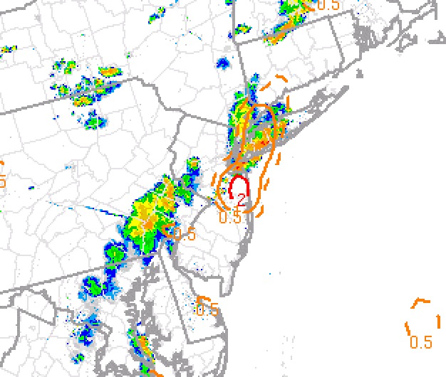
Also notable was a brief area of rotation in one of the stronger storms over Queens and Nassau counties. If you weren’t paying close attention, you may have missed it. In fact, even using Doppler radar out of Upton, NY (KOKX) or Mount Holly, NJ (KDIX) wouldn’t necessarily have keyed you in to the rotation. But a zoom into Terminal Doppler Radar Data (TDWR) out of JFK Airport revealed something more interesting.
As the storm tracked southeastward through Queens and towards Southern Nassau, notable rotation quickly developed. The imagery attached shows the radar’s storm-relative velocity data. Red colors show winds moving away from the radar beam, and green colors show winds moving towards it. Where the two colors meet, rotation often occurs. We call this a “couplet”.
Velocity data from the radar at JFK Airport showed a small, but compact area of rotation moving over portions of southern Long Island from around 7:40pm to 7:54pm this evening. There have been no reports of damage at this time. #NYwx pic.twitter.com/Rbo3sUwkYu
— NY Metro Weather (@nymetrowx) August 8, 2018
This couplet occurred close to the radar beam – only about 600-700 feet above the ground. It was not surprising when a few photos began streaming in of cloud structure in this region, but one in particular got a lot of attention. This Facebook video shows a wall cloud moving directly through the area of rotation – the user says they filmed the video on the Queens/Nassau county border.
There has been some discussion on whether or not this is a scud cloud, shelf cloud, or wall cloud. I can tell you with near certainty – it is not either of the former. This is most certainly a wall cloud, backed up by meteorology and radar data. In addition to the previously discussed velocity data, MRMS rotation tracks show a localized rotation maxima right near the area where the photo was taken – this storm was rotating and the wall cloud is evidence of that.
So what is a wall cloudy exactly? In simple terms, it is a lowering of clouds that develops beneath the base of a thunderstorm. While they don’t always rotate, they often do, and they are often associated with or precede tornadoes, funnel clouds, or both. More importantly, they are indications of a mesocyclone within a thunderstorm, which most tornadoes form from.
I have seen many comments suggesting the wall cloud in NYC was not, in fact, a wall cloud. I’m not so sure that is correct. The photo was taken from the Queens/Nassau county border looking directly at this area of enhanced rotation. That’s a wall cloud, folks. #nywx pic.twitter.com/nZEinhbB6k
— John Homenuk (@jhomenuk) August 8, 2018
What caused this mesocyclone to form is up for debate. Severe weather parameters were not necessarily impressive; ample instability was present, but shear was lacking. This storm was living a short life – it matured quickly, and was on its way towards collapsing when the mesocyclone developed. Without sufficient shear to keep the storm moving, the downdraft falls on top of the storms structure and the rain cooled air weakens the storm altogether.
With this in mind, it is very likely that the mesocyclone was enhanced by a local boundary or locally backed low level winds. The Storm Prediction Center mesoscale analysis also offers a tip-off to this potential: The non-supercell tornado parameter was notably high in this region. This parameter is meant for this exact scenario, when instability is high, shear is low, but local environments can support brief or weaker tornadoes.
SPC Non Supercell tornado parameter showing the potential for weak tornadoes in nassau and queens counties on Tuesday evening
It is uncertain at this time whether or not a tornado touched down. There have been sporadic wind damage reports in this region, but nothing sustained or indicative of a tornado, so our guess it that no tornado formed. The cloud observed, however was notable in its own right, and the lightning was unfortunately memorable for other reasons as well.
Additional storms are expected today. Follow our latest post for the most recent information.