-2")
NYC Weekly Planner: Hot hot heat, humidity and storms
Welcome back to summer. After a few glorious days of temperatures in the 80’s and low dew points, the southerly flow is back – and it is bringing warmer, more humid air with. High pressure remained in control for most of the weekend, which was undoubtedly a nice change. But clouds have increased this evening and will continue building through the overnight. There may even be an isolated shower or two tonight.
The real change comes on Monday, as the advection of a very warm airmass truly begins. A large ridge will build into the Northeast in the mid and upper levels of the atmosphere, helping to push in the warmer airmass. High temperatures are expected to reach into the upper 80’s, but dew points will increase notably and the airmass will feel much more humid. There is the chance for a few isolated showers or storms during the afternoon.
Tl;dr: Trending hotter Monday, hot as all ever-loving heck on Tuesday, Wednesday and Thursday, storm chances increasing from Thursday into the weekend with the potential for lots of storms Friday and Saturday.
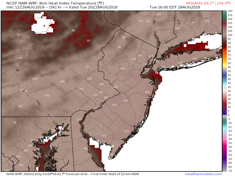
NAM3km model suggesting heat index values over 105 F on Tuesday afternoon.
Tuesday – The heat begins
The most notable surge of heat and humidity comes on Tuesday. Forecast model guidance is in good agreement that the ridge will peak over the Northeast states during this time, with a humid airmass overhead and very warm temperatures aloft. This suggests high temperatures in the middle to upper 90’s – and painfully high heat index values in the lower 100’s. The NAM3km model in particular (pictured) suggests that heat index values may approach or exceed 105 F in some areas.
Needless to say, it will be important to limit exposure to the sun during this time – if you can. And if you can’t, be sure to remain hydrated. We also always recommend keeping a close eye on pets, children and the elderly. Doggos, little Jimmy and Grandma Doris are more susceptible to heat-related illness than anyone else.
Wednesday & Thursday – The heat continues
The heat is expected to continue on Wednesday and Thursday, as the large ridge remains settled over the region. Heat index values may approach or exceed 100 F in many areas of New Jersey and the NYC Metro. The European model, for instance, suggests surface “skin” temperatures (in other words, the temperature of the surface of the Earth where plants, animals, and us humans live) will approach 98 F in Northeast NJ and NYC on both Wednesday and Thursday.
As the week goes on, the chances for isolated and scattered storms will increase. This appears especially true on Thursday, when a frontal boundary approaches the Northeast states later in the day. The best chance for storms will be over the Interior, and a few of them could be strong or severe. The timing of the front will be important in determining how far east storms get towards the coast any thunderstorm activity gets.
The European model suggests the potential for widespread showers and storms from Friday into Saturday.
Friday & The Weekend – Uncertainty abound
The forecast becomes extremely murky by the end of the week and weekend. Forecast model guidance is struggling in handling the movement of a cold front, forecast to sink towards the Mid-Atlantic states from late Thursday into Friday. There are two distinct scenarios – one which you will be fond of, and one which you will most definitely not be fond of. The latter appears on today’s European model: The frontal boundary gets caught up in the Mid-Atlantic on Friday, and a disturbance develops along it. This leads to showers and thunderstorms over a widespread area from Friday into Saturday.
The former scenario appears on todays GFS model, with the frontal boundary sinking southward and the disturbance remaining weaker. A few showers and storms would be possible on Friday but the forecast would generally be less humid and pleasant for the weekend. Needless to say, we’ll be watching closely – but we have opted to include a chance of showers in the forecast for the upcoming weekend. We have seen several frontal boundaries get stuck near our region this year and the pattern we are in now suggests this could be another one – if we had to bet, we’d lean towards the more unsettled European solution with rain chances on Friday and Saturday.
But we will see – for now, buckle down and get the iced coffee ready. It’s going to be a hot start to the week.
Leave a Reply
Want to join the discussion?Feel free to contribute!