-2")
Ridge over troubled waters: Tropical Atlantic ready to wake up
It has been a long, quiet summer. While heat and humidity have been recurring forecast themes in the Eastern and Central United States, the weather pattern throughout the tropical Atlantic has remained stagnant, if not dormant. There have been a myriad of factors that have contributed to a very quiet start to the season in the Atlantic – ranging from Saharan dust to anomalously cool sea surface temperatures and everything in between. Over the next week or two, however, the pattern is set to change and the implications could be notable.
The 2018 Atlantic hurricane season got off to a fast – and in retrospect, ironic – start with Alberto on May 25th. There have been a few other storms that have meandered around since then (the most notable being Hurricane Chris) but the season has thus far been sporadic at best. It can be more accurately defined as unusually quiet. The weather pattern in place has been arguing vehemently against the development of any tropical cyclones in the Atlantic, specifically in the MDR (Main Development Regions). Sinking air, Saharan dust, and unfavorable wind shear have all been major contributing factors, and unusually cold sea surface temperatures have made the environment even more hostile. 30-Day Accumulated Cyclone Energy (ACE) was running near or below the 25th percentile.
The 2018 Atlantic hurricane season has been unusually quiet for the time of year.
The next 30 days feature the climatological max in ACE. Conditions will continue to be unfavorable for TCs, and there's a high likelihood of peak-season ACE falling below the 25th %ile. pic.twitter.com/4qX2wrun3S— Sam Lillo (@splillo) August 19, 2018
But forecast model guidance has been sniffing out a change
The ECMWF EPS have suggested for several days now that the anomalous sinking air will finally relent, and the atmospheric conditions in general will become more favorable for tropical development as we head towards the peak of the Atlantic hurricane season. Multiple waves may begin to advance westward off the African coast into the Atlantic, and with sea surface temperatures warming to near or above normal – a major change from the past few weeks – storms could find it much easier to develop.
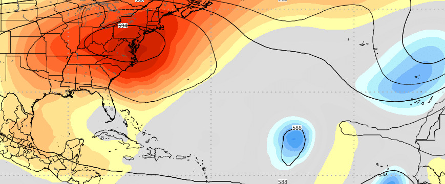
Perhaps more concerning is the weather pattern closer to home. Large, sprawling mid and upper level ridges have become a common feature from the Mississippi River Valley into the Eastern United States over the past few weeks, and forecast models suggest this pattern may continue until at least the middle and perhaps the latter part of September. This is important, as the steering currents for tropical activity could become quite precarious. Some of the more notable tropical systems have tracked “under” large ridges into the waters off the Southeast United States or Gulf of Mexico.
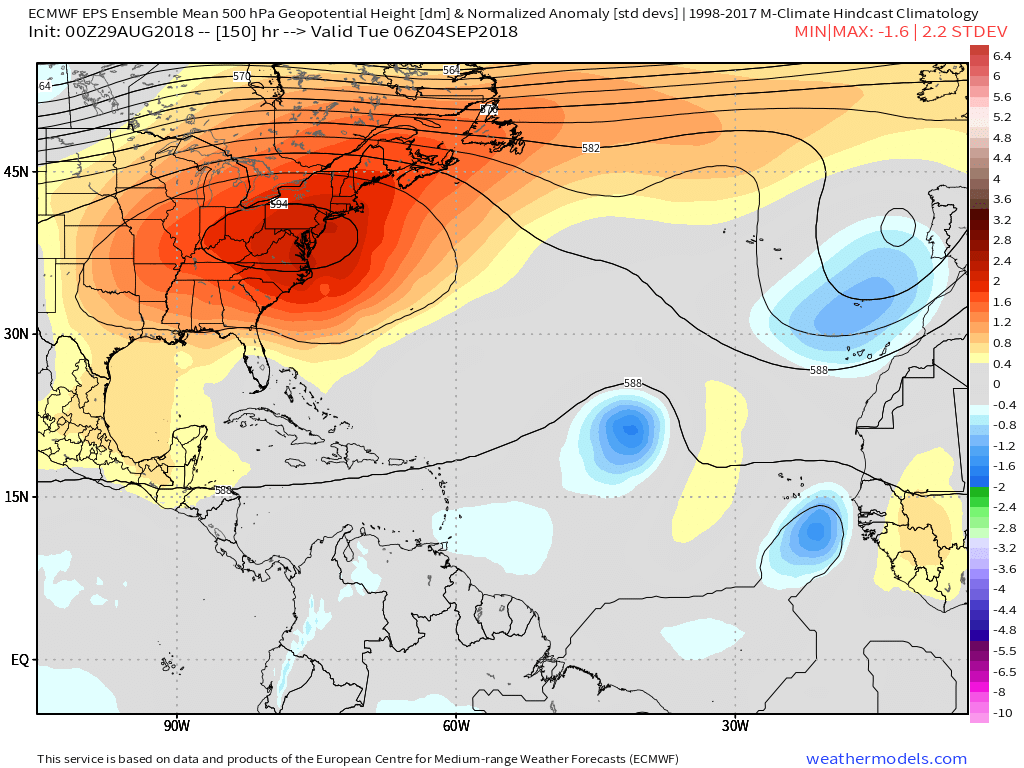
Forecast models suggest tropical activity will increase in the Atlantic over the next two weeks.
Storms that form off the African coast and track northwestward could have an “Escape route” of sorts into the Atlantic, but any storms that do form closer to the Southeast US coast or Gulf of Mexico could be “blocked” from any sort of seaward escape.
Potential for growth close to home
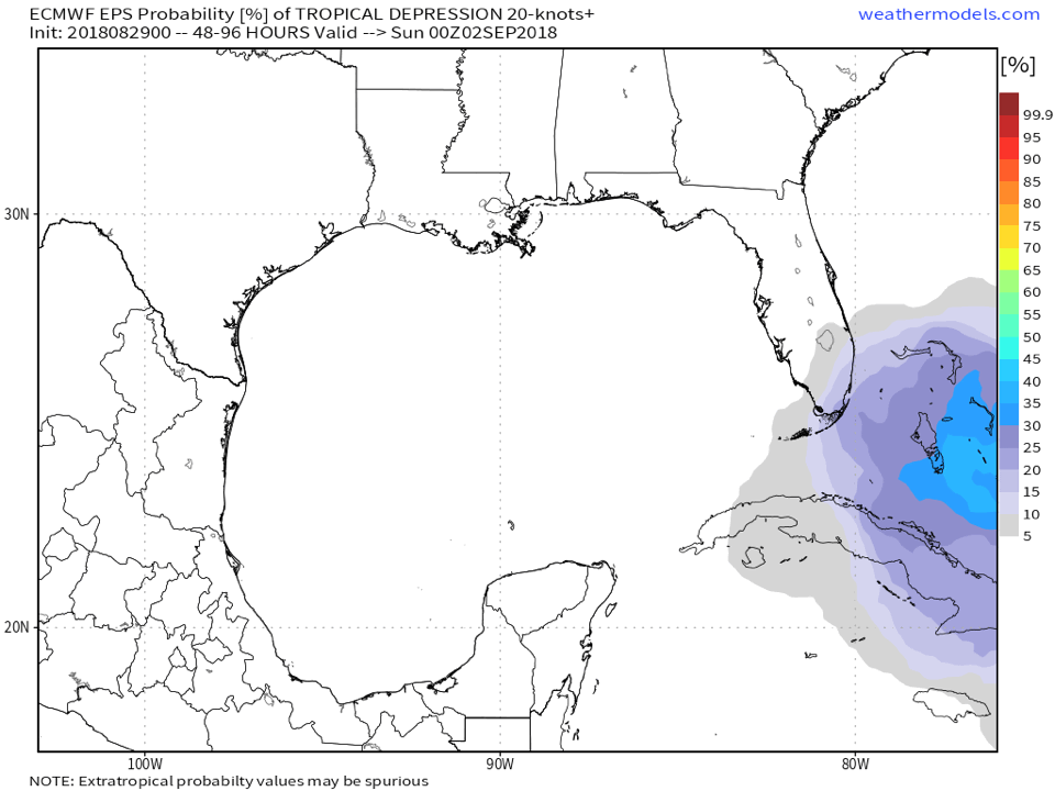
In addition to the potential for waves to develop off the coast of Africa, forecast model guidance has been sniffing out the potential for tropical development in the waters off the Caribbean Islands and nearer to the United States. Underneath the large mid level ridge, the ECMWF EPS and to some extent the GFS are suggesting that a weak tropical low or trough could develop next week. While conditions do not currently appear overly favorable for strengthening, organization could occur as the disturbance shifts into warmer waters and away from wind shear.
The ECMWF EPS suggest moderate probability of tropical depression formation near Florida, with those very same probabilities shifting into the Gulf of Mexico. It remains to be seen exactly how this system develops and where it tracks, so uncertainty is very high at this time. But the system certainly bears watching given the ensemble signal and overall synoptic pattern.
The takeaway: Things are about to get busier
The main takeaway from most meteorological evidence, particularly the evolution of the synoptic weather pattern, is that Atlantic tropical activity is about to increase. Individual disturbances are going to be very difficult to forecast at this juncture – and attempting to pinpoint any threat regions or focus in on any particular disturbance would be a fools errand at this time.
Instead, it is important to communicate that things are likely to get busier over the next few weeks. The weather pattern which was once anomalously unfavorable for any development is changing, and we are likely to see an increase in tropical threats of some sort as we head into the next few weeks. We will, of course, have further information as the developments continue!
Leave a Reply
Want to join the discussion?Feel free to contribute!