-2")
Weekend Outlook: A brief respite from anomalous heat
Cloudy, drizzly, and cool weather has taken over today throughout the Mid Atlantic and Northeast states, with the exception of far northern New England. The cooler weather comes as a welcomed break from oppressive heat and humidity, which to this point has become a steady feature in the areas weather during the second half of August. With meteorological Autumn set to begin on Saturday, many are turning their attention to the potential for cooler, more crisp airmasses. They will have to wait, as heat will return once again next week.
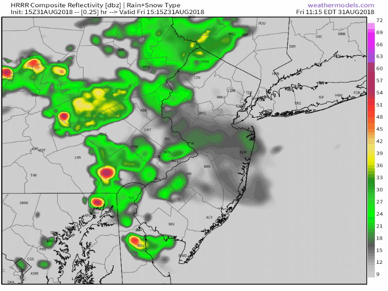
To back up for a moment, the weather for the remainder of today looks cloudy, wet, and cool. Temperatures will actually run below average for the first time several days, thanks mostly to showers and clouds. As a disturbance continues to shift by, models suggest sporadic periods of rainfall are possible into Saturday morning.
Showers will continue through tonight before the weather improves overnight into Saturday.
The weather during this three day stretch will be rather changeable. To start, additional areas of showers are expected later tonight. The latest short term models suggest these could contain heavy rain and downpours in some areas, particularly from Eastern Pennsylvania into New Jersey.
As the evening goes on, showers will become more isolated. Lift – which is an essential factor in getting precipitation – will weaken, and the areas of heavy showers will disappear. By Saturday morning, we expect just a few light showers remaining, although it will continue to look and feel unsettled with cooler than normal temperatures.
The weather improves as the day goes on on Saturday, and this clearing trend is expected to continue into Saturday night. The disturbance and frontal boundary near the area will wash out and weaken, and high pressure will begin to take over. Sunday will mark a day of change, with warmer air and ridging building into the Northeast states in the atmosphere’s mid and upper levels.
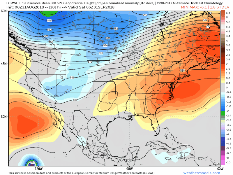
Another large ridge builds over the East next week – with additional heat expected.
By Monday, temperatures will have rocketed above average once again. Heat Index values are expected to reach above 90 F as warm southerly winds begin to increase – and moisture will increase as well as dew points approach the 70 F mark.
This will mark the beginning of another stretch of heat – starting Monday and escalating significantly from Tuesday into Wednesday. Heat Index values are likely to rise above 95 F once again as a large, sprawling ridge settles over the Northeast states.
We’ll enjoy the cool and damp weather for now. Have a wonderful weekend!
Leave a Reply
Want to join the discussion?Feel free to contribute!