-2")
Extremely dangerous Hurricane Florence heads towards Carolinas
Hurricane Florence weakened briefly this morning, but remains a powerful Category 4 hurricane with maximum sustained winds of 130 miles per hour. The weakening can mostly be attributed to an eyewall replacement cycle or “ERC”, which occurs when the inner eye-wall of a hurricane erodes in favor of a larger, more expansive one. The good news is the temporary weakening of the storm system. The bad news is the window for additional strengthening that occurs afterward.
To make matters worse, Florence is set to enter a nearly optimal environment for strengthening later today. Anomalously warm ocean temperatures, some of the warmest in the Atlantic Ocean, lie ahead of the storm. In addition, low mid level atmospheric shear will allow the storm to properly ventilate. After the eyewall replacement cycle is complete, Florence may additionally strengthen today, perhaps approaching Category 5 status.
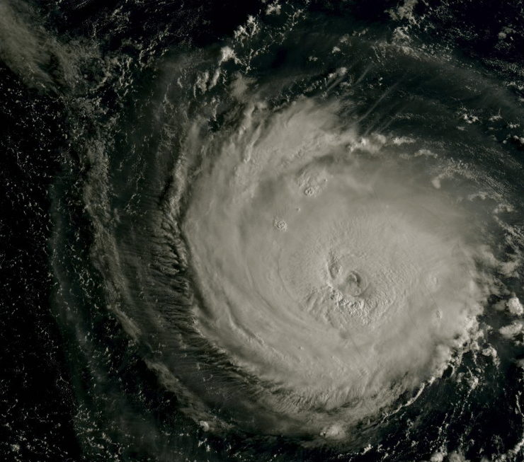
Hurricane Florence was completing an eyewall replacement cycle this morning while expanding in size.
The system is expected to continue moving northwest over the next two days while accelerating. Forecast models are in good agreement on the overall heading, but there is still some divergence once the system approaches the Carolinas as to how exactly it will track. The European model and its ensembles, for example, take Florence further south with a track into Northern South Carolina – close to Myrtle Beach.
The GFS and other global models, including the HRWF, are further north and take Florence close to Cape Fear in North Carolina with a landfall near or south of Wilmington on overall average. These two scenarios will obviously result in wildly different impacts on a local scale. It will be critical to monitor the behavior of Florence today after the eyewall replacement cycle is complete. Forecast models which take the storm into South Carolina track the system further south almost immediately later today.
As mentioned, Florence will enter an environment favorable for strengthening later today and Wednesday. Very low atmospheric wind shear will allow for enhanced ventilation of the storms outflow. In addition, warmer ocean temperatures will allow for further strengthening of the system. Once the eyewall replacement cycle is complete, Florence could become a very powerful Category 4 or 5 hurricane with a large eye and extremely powerful winds.
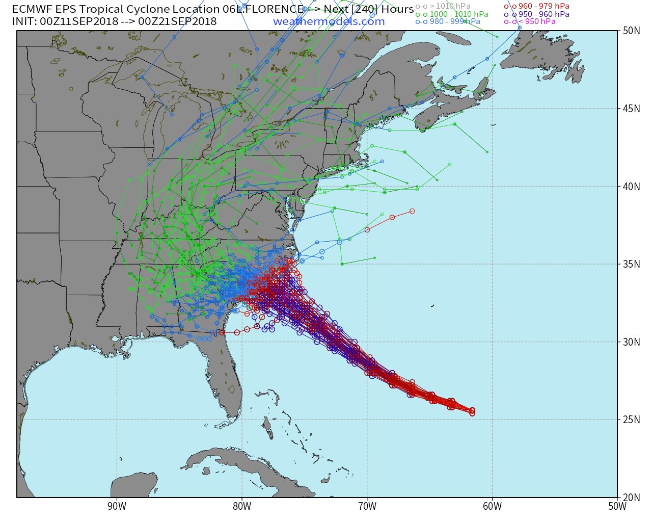
There is still some spread in regards to the exact location where Hurricane Florence makes landfall, with the Euro Ensembles showing a range from South Carolina to North Carolina.
Looking past the exact track – hazards and threats
While it may be difficult to do from a semantics standpoint, it is important for residents of the Carolinas to look past the specifics of the track in regards to Florence. Regardless of where Florence tracks and makes landfall, whether it be in Myrtle Beach, Wilmington, or somewhere else, Florence is an extremely dangerous hurricane. It is powerful, expansive, and dangerous in every sense of the word. Residents from the South Carolina coast to the Outer Banks should be rapidly completing preparations today. Residents inland in the Carolinas and parts of Virginia should be preparing for dangerous impacts as well.
There are several life-threatening hazards from Florence:
- Life-threatening storm surge at the coast – a rise in ocean water over normally dry land that may be several feet high
- Life-threatening freshwater flooding from a prolonged and exceptional rainfall event from the coast to the interior sections of the Carolinas and Virginia
- Damaging hurricane-force winds near the coast
The storm surge along the immediate coast is expected to be life-threatening and perhaps a generational event for parts of the Carolina coastline. Storm Surge Watches have been issued for many regions along the immediate Carolina coastline with a rise in water of several feet possible. Residents within the Storm Surge Watch region should be preparing to evacuate if orders were not already issued.
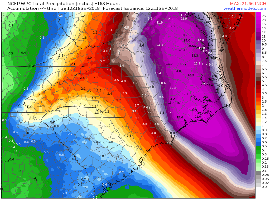
WPC is forecasting upward of 20″ new rainfall in some parts of the Carolinas.
The rainfall threat will continue well inland, and NHC is warning of life-threatening freshwater flooding from the storm surge in addition to a prolonged and exceptional rainfall event from Florence. As the system slows and tropical moisture continues to meander over the area, 15-20″ of rainfall are possible in some areas. This amount of rainfall on top of moist soil and a prolonged tropical fetch will lead to widespread, life-threatening flooding.
Finally, damaging hurricane-force winds will be a very dangerous threat near the coast and even inland by many miles as the storm comes ashore. Forecast models suggest wind gusts over 100 miles per hour will be commonplace where Florence makes landfall. Winds of that nature can cause widespread property damage.
Preparation Steps & Evacuations
Many local counties, states and cities in the Carolinas have issued mandatory evacuations at this time. Please check with your local officials and request information on any evacuation orders that may be in place. If a mandatory evacuation is in effect, please carefully follow instructions.
If you are inland from the coast and choosing to ride out Florence, there are several preparation steps that you can take to protect your property and life:
- Understand your housing structure. Understand your home and whether it will be able to sustain winds, water, or an intense hurricane. If you do not feel safe, or comfortable, evacuate.
- Understand your flood zones and storm surge risk. See the map above (Storm Surge Watch) for areas that may be prone to storm surge with this storm
- Have a hurricane kit. If you do not have one or know what this is, check with local stores such as Home Depot or Walmart, or call a local official for information.
- Stock up on essentials including water, milk and canned foods. As a general rule, have enough food to survive for more than a week in case of power loss or lack of transportation.
- Check with the elderly and neighbors. As a general rule, elderly and disabled are less likely to evacuate. Make sure that they are making the right decisions.
- Be sure to understand that once hurricane-level conditions begin, emergency officials may not be able to reach you. You may be on your own. Make sure you are comfortable with your decision to stay through the storm
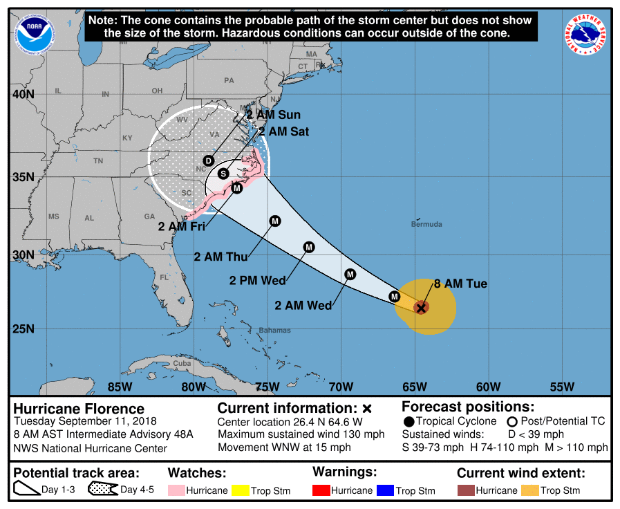
Official NHC track and information as of 8:00am Tuesday.
Final Thoughts and Information
Florence is likely to be a very dangerous, powerful hurricane at landfall. Even if the system were to weaken upon approach, widespread damaging impacts are still likely due to the current size and intensity of the storm. Our advice to residents of the Carolinas, especially those along the coast, is not to take Florence likely. If you are on the fence about evacuating to a safer location, evacuate to a safer location.
As a reminder, always check with the National Hurricane Center and your local officials for official, detailed information. If you have any questions, contact them immediately.
Finally – we are continuing to provide completely free consulting-level forecasts for businesses and individuals in the Carolinas and Virginia over the next three days, in an effort to increase communication and promote safety and understanding ahead of the storm. Please contact us immediately if you feel this information will be useful to you.
Leave a Reply
Want to join the discussion?Feel free to contribute!