-2")
Florence may not make landfall in North Carolina. Does it matter?
More than seven days after meteorologists first started tracking what would become Hurricane Florence, the weather pattern we have been advertising as “extremely unusual” finally threw another curveball at us. Forecast models over the past 24 hours have come into better agreement on the idea that Hurricane Florence will put on the brakes as she approaches the Carolina coast, coming to nearly a complete halt and turning southwesterly along the coast.
In fact, some models suggest that the storm may not even make an official landfall in North Carolina at all – instead, it will float southwestward toward South Carolina before weakening and moving inland. This has left the public with a lot of questions. What is going on? What does this mean, and should we believe it? Does this matter in terms of overall impacts? Does this new change in the track of Florence really matter for those in its path? The answers aren’t simple, but they are there – and forecast models have been giving us clues all along.
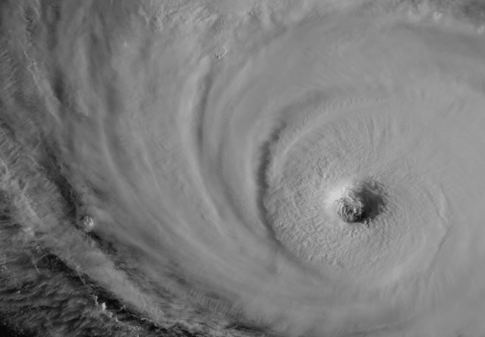
Hurricane Florence this morning. Imagery via GOES-16.
Why is the storm suddenly forecast to come to a stall?
Hurricanes are largely controlled by steering currents within the mid levels of the atmosphere. Without getting into too much technical detail, think of these steering currents as the impetus for the larger movements of these storms. While individual perturbations and mesoscale features can cause wobbles in movement, larger atmospheric patterns (such as ridges and troughs) often control the storms overall/larger-scale movement.
For instance, Hurricane Florence was pushed south and westward over the past few days as a result of a large ridge of high pressure to its north. This meant that the storm could not feasibly escape northward or out to sea. Instead, it was pushed west towards the United States. The storm is being “steered” northwesterly, and has been generally moving that way for a day or so. It is expected to continue that way for the next 24 hours.
As the storm system begins to approach the Carolinas, the atmospheric pattern around Florence will become convoluted. The mid level ridge which had been steering the storm will become quite large and expansive, and another ridge to the west of the storm over the Central Plains will amplify as well. This already creates some resistance – so the storm had been expected to slow down.
While it’s easy to marginalize model runs – or in some instances, glorify them – it’s more important to try to figure out what they are trying to say. Today’s guidance suggests #Florence slows to a crawl when interacting with this subtle shortwave underneath a large ridge. pic.twitter.com/jQ4rszJF59
— John Homenuk (@jhomenuk) September 11, 2018
Compounding matters is the fact that an area of strung out/weak vorticity is forecast to move eastward from the Tennessee Valley in response to a weak trough ejecting from the Plains states. Forecast models now suggest that this area of vorticity will slide eastward and then over the top of Florence – acting to nullify any remaining momentum that she had. As the steering currents around her begin to weaken, and additional resistance arrives from the aforementioned features, Florence will slow to a screeching halt.
While it may look silly on forecast model maps or ensemble plots, meteorologically this idea makes sense. In fact, it is the favored idea at this time.
What does this mean in terms of impacts and preparations?
Earlier in the post we posed the question: “Does this new change in the track of Florence really matter for those in its path?”
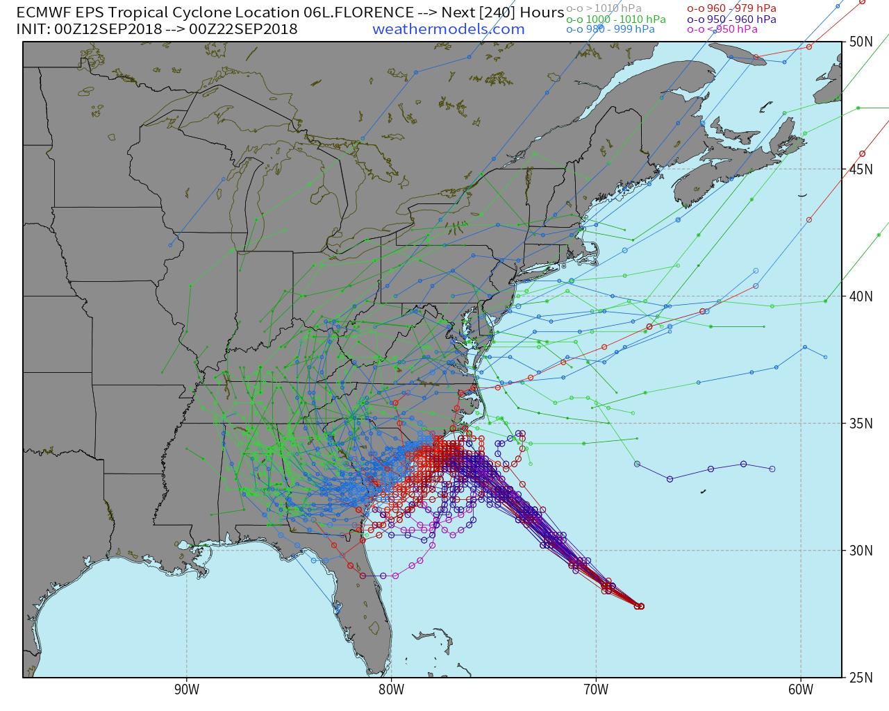
Ensemble tracks show Florence coming to a complete stop near the North Carolina coast.
The short answer, in terms of preparation, is no. All interests along the coast should continue to prepare for the approach of a major hurricane, and all interests inland in the Carolinas should be continuing to prepare for major freshwater flooding potential. If you are in the path of the storm, you now have less than 24 hours to prepare, so now is the time to make final preparations.
From an impact standpoint, Florence coming to a complete halt near or barely off the North Carolina coast, and then drifting southwestward along the shoreline presents a whole new set of complications. While the storm may not make an official landfall in North Carolina in this scenario, a powerful hurricane will still be meandering near or just off the coast.
As a result, powerful winds are still expected near the shore. In addition, life-threatening storm surge is still likely, especially near or just north of the storms center as easterly winds surge toward the coast. The slowed nature of the storm means that this storm surge and onshore wind could be prolonged, leading to widespread coastal damage, flooding, and beach erosion.
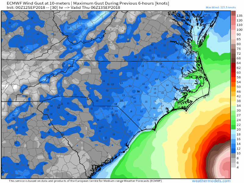
Wind gusts will still be very dangerous whether Florence makes landfall or not.
As the storm shifts gradually southward, the risk for prolonged storm surge will continue along the North Carolina beaches. Inland, tropical moisture with a slowed system could lead to widespread life-threatening freshwater flooding. The system could meander off the coast for longer than 24 hours without moving very much, leading to prolific rainfall totals.
Depending on where the storm goes after slowing down considerably, the risks for storm surge, strong winds, and torrential rain could spread southward into South Carolina.
What do we do for the next 24 hours?
All interests along the Carolina coast, and even inland, should continue preparations just as they were for the past few days. Continue to follow all evacuation orders and continue to err on the side of extreme caution. This is a very dangerous storm – whether it makes a technical landfall in North Carolina or not will not change the fact that dangerous, life-threatening conditions are expected.
We have designed a page where residents can check on the status of Hurricane Florence and reference important preparedness information. You can view it here.
Trackbacks & Pingbacks
2cornish
Leave a Reply
Want to join the discussion?Feel free to contribute!