-2")
NYC Area Forecast: Unsettled weather continues as Florence stays south
Good morning! Over the next few days, a large upper-level ridge will be building into the area from the Western Atlantic Ocean. Ridges like this would typically support the return of hot and humid conditions, but the area is sandwiched between high pressure to the north and Hurricane Florence off the Southeast US coast. As a result, an onshore flow has persisted and a frontal boundary has lingered over the region. This has lead to unsettled and muggy weather, which will continue into the weekend before high pressure takes over.
This morning, a frontal boundary has begun to wash out over the area. Showers, fog and clouds are continuing for the time being, and are likely to persist at least in some areas throughout the day. Gradually, though, subsidence (or sinking air) will begin to increase later today and tonight. This will lead to improving conditions during each afternoon as we go through the weekend. The mornings will likely still be marred by low clouds, moisture and some patchy fog with moisture trapped underneath an inversion.
High pressure from the northeast finally begins building over the region this weekend. Skies may not completely clear thanks to an onshore flow off the ocean, but generally conditions will improve and we may actually see the sun for the first time in what feels like an eternity. High temperatures will gradually rise into the 80’s.
Meanwhile, Hurricane Florence remains a dangerous hurricane just off the coast of the Carolinas this morning. As steering currents underneath the Western Atlantic ridge weaken, the storm will likely become nearly stationary, near or just off the North Carolina on Friday while significantly impacting the Carolina coast and inland locations with heavy rain, dangerous storm surge and winds.
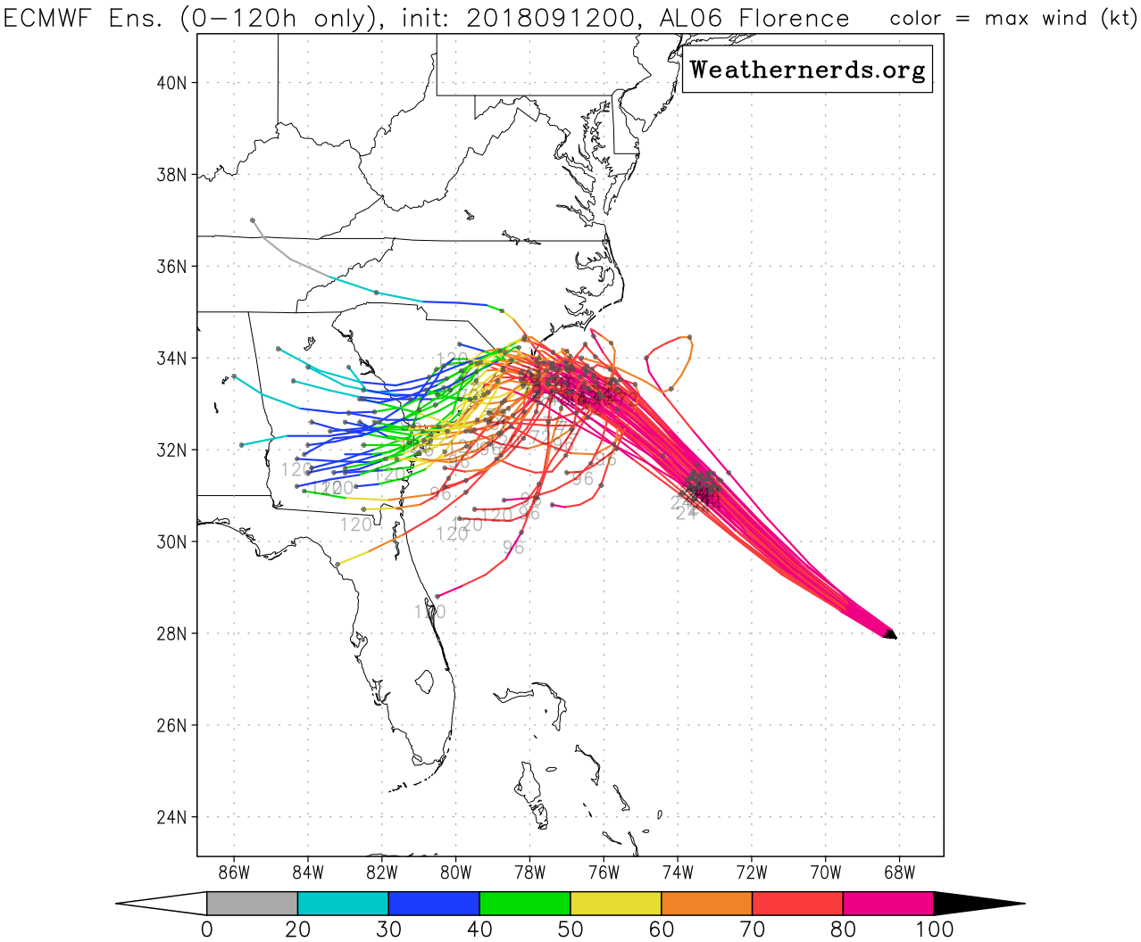
Majority of the overnight ECMWF EPS ensembles track Hurricane Florence further southwest into South Carolina and Georgia
This scenario is a real nightmare for forecasters, as it will be more difficult to determine the magnitude and longevity of impacts for Southeast US. Florence is likely to weaken somewhat over the next 24 hours due to increasing shear and some upwelling of cooler waters as it slows down before reaching the Southeast US. However, if the center of the storm tracks just offshore or along the coastline, that weakening trend will be slowed. The storm will remain large and intense enough to cause major flooding from a prolonged storm surge and heavy rainfall through the weekend, especially over the coastal communities over the Carolinas. Anyone with any interests in these areas should not take Florence lightly and should continue to heed all warnings and take all necessary precautions.
For the local region, Florence will cause dangerous rip currents, higher surf and beach erosion along the New York and New Jersey Atlantic shores and beaches late this week and perhaps into this weekend. However, the large ridge that builds over the weekend is expected to block Florence from moving northward into the Northeast US, at least for several days, until perhaps the middle of next week. At that juncture, the remnants of Florence may begin to get dragged northward into the local area.
Stay tuned for more forecast updates to come later this week.
Leave a Reply
Want to join the discussion?Feel free to contribute!