-2")
NYC Area Forecast: More rain likely tonight into Friday morning
The Brief: Heavy rainfall is likely tonight into Friday. The NWS has issued a Flood Watch for a large majority of the Mid-Atlantic into New England. Localized flooding is a distinct possibility. The weather clears up for Friday and the weekend.
A forecast that once looked pleasant during the latter half of the week has turned unsettled, and you can thank the upper level jet stream (among other things) for that. Instead of cool, crisp air and sun, the end of the week will feature a period of heavy rainfall from late Thursday night into Friday as another low pressure system develops offshore and sends moisture surging up the coast.
Previously, forecast models had suggested that the rainfall would remain well offshore and that any impacts would be periodic and/or non-impactful. As recently as Tuesday, however, hints began to emerge that the forecast was changing. Forecast guidance was tweaking the orientation of the upper level jet stream, and the trends were a tip-off to the fact that the forecast late this week was about to take an ugly turn.
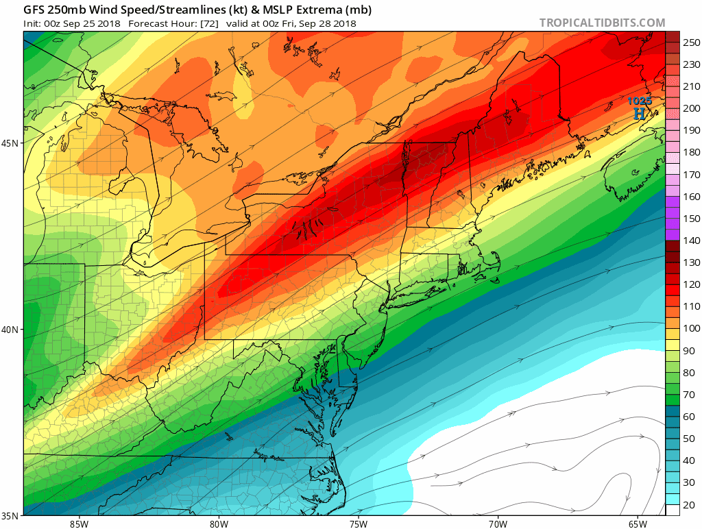
Models have trended more expansive and stronger with an upper level jet streak (watch over Southeast Canada), allowing for more rain tonight into Friday.
In the upper levels of the atmosphere, a strong jet streak can act to enhance or mitigate precipitation potential. In this case, the positioning of the jet streak has changed on forecast model guidance so that it is now stronger, and more impressive over New England. Our area is now placed within the favorable “right entrance region” of the upper level jet, which acts to enhance divergence and allow precipitation to expand.
This enhanced “breathing room” and jet dynamics means precipitation can expand more willingly up along the coast. Previous model cycles had suggested the storm would be suppressed or squashed with minimal dynamic support from the jet stream. The trends with the jet stream earlier this week gave us a clue that model guidance was trending toward a more amplified solution – so it wasn’t surprising yesterday when we saw the NAM, GFS and ECMWF suddenly show much more rain from tonight into Friday.
Often times, watching these trends and understanding the synoptic evolution of major jet features in the atmosphere can help us stay a step ahead of the weather models. There’s a reason why we call them forecast model guidance in the first place! We should be using them as supplementary tools to our forecasting process after we do our best to understand what the atmosphere is really doing.
What’s going down from tonight into Friday though?
The potential exists for a period of very heavy rain and localized flooding in parts of PA, NJ, NY and CT tonight, as moisture surges northward. Enhanced lift and impressive upper level dynamics overnight. #njwx #nywx #pawx #ctwx pic.twitter.com/yWdYejTDNH
— John Homenuk (@jhomenuk) September 27, 2018
Okay, I digress. Rain is expected to surge northward up the coast later this afternoon and evening as a low pressure system develops off the coast. With the enhanced mid/upper level jet dynamics that we discussed, it will have no problem expanding northward. Models suggest that rain should expand all the way into Northern New England later tonight by the time all is said and done.
Much of the rain will come overnight, so it won’t directly impact any major commutes (as it stands right now). Still, a period of torrential rainfall seems increasingly likely. Forecast models are suggesting enhanced lift for precipitation will align with impressive moisture as a low level jet surges northward during the early morning hours on Friday.
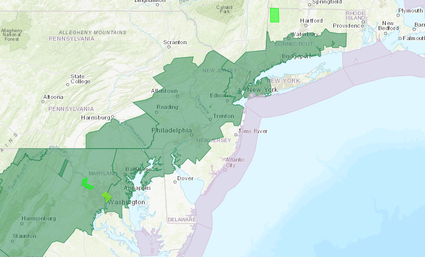
The NWS has issued a Flood Watch for the areas in green. The potential exists for over 2″ of rain.
At the same time, enhanced warm air advection at 850hPa and an area of frontogenesis (does it sound like we’re talking about a winter storm yet) will provide the opportunity for enhanced dynamics and torrential rain. Flooding is possible in some areas as this band lifts northward, and some areas may see several inches of rainfall if the dynamics do come together as models suggest.
The good news, overall, is that the system is mostly transient. The heavy rainfall moves northward and the low pressure system skirts off the coast so that by Friday, conditions will begin to clear out. This will lead us into a much more pleasant day overall by Friday afternoon.
The weekend, while we’re on the topic, looks cooler and calm as high pressure gradually builds into the Northeast states. In fact, it looks to be one of the nicer weekends in quite a while. Once we get through the rainfall from tonight into Friday, it’s smooth sailing (until Monday of course).
Have a great Thursday, and make sure to check back for updates on the storm system on our social media accounts later today.
Trackbacks & Pingbacks
1regional
Leave a Reply
Want to join the discussion?Feel free to contribute!