-2")
Slight Risk for severe storms today, gusty winds possible
Showers and thunderstorms are likely to form in the Northeast later this afternoon, as a low pressure system moves through Southeast Canada and parts of Northern New England. Several of the storm could be strong or severe, with the potential for torrential rain, gusty winds, and dangerous lightning. While the threat for severe storms appears focused over Pennsylvania and interior New York State, some strong and severe storms may also leak towards the Lower Hudson Valley and NYC Metro later today.
The Storm Prediction Center has accordingly placed much of the aforementioned area in a “Slight Risk” for severe thunderstorms later today, including parts of Central and Northern Pennsylvania, Northern New Jersey, the Lower Hudson Valley and the western fringes of the NYC Metro.
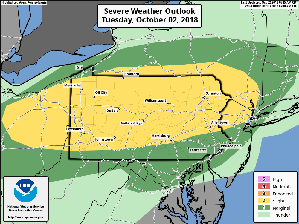
Day 1 convective outlook from the Storm Prediction Center.
The latest technical discussion from the Storm Prediction Center highlights the threat for storms throughout the Northeast later today quite succinctly:
Moderate to strong unidirectional westerly flow is expected above 1 km, helping to
support both strong vertical shear and fast storm motions. Given the
somewhat modest forcing for ascent, a semi-discrete storm mode is
anticipated with bowing line segments capable of damaging wind
gusts. Some hail is also possible within the strongest updrafts,
which appear to be more probable across portions of OH and western
PA where greater instability is more likely.
In simpler terms, the potential exists for a somewhat “organized” severe weather threat today, instead of just widely scattered storms. You can thank ample wind shear for that – wind shear is a key component of organizing strong and severe thunderstorms, and we have plenty of it today. Plenty of instability also exists, “fuel” for storms, and frontal forcing or lift will help storms develop. Those are the “big three” factors that we look at for storms in the Northeast – and they are all present to varying degrees today.
Timing, hazards, and more
Thunderstorms are expected to develop over North-Central Pennsylvania and New York State first, likely starting during the very early afternoon hours today, closer to the frontal boundary and low pressure system. The expectation is that these will shift gradually eastward, moving towards Northeastern Pennsylvania and the Lower Hudson Valley by the middle afternoon hours. It is at this time that storms may begin to strengthen.
Why? An axis of unstable air is expected to align with favorable wind shear in this region. This means that storms will have an opportunity to strengthen and organize, and accordingly the potential exists for strong, damaging winds in a corridor from Northeast Pennsylvania to Southeast New York (perhaps including Northern New Jersey) from late this afternoon into the evening.
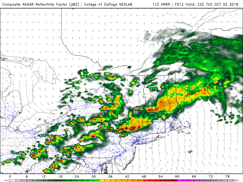
Short term models suggest severe storms will move into the LHV by early this evening.
Thereafter, storms are expected to encounter a gradually less favorable environment. As they move towards New Jersey, the NYC Metro and Connecticut, the atmosphere will become less unstable, which suggests storms may begin weakening as they move toward that region. Still, during the early evening hours, a few marginally strong to severe storms may impact those regions, with the threat for gusty winds, heavy rain and lightning.
Bottom Line
Expect strong to severe thunderstorms in parts of North-Central Pennsylvania and Southern New York State during the early afternoon, moving southeastward towards the Lower Hudson Valley and Northeast Pennsylvania during the late afternoon hours. These very same storms will weaken, but approach parts of Northeastern New Jersey, Connecticut, and the NYC Metro during the early evening hours.
The weather is expected to very gradually improve overnight, with much calmer conditions throughout the Northeast on Wednesday. As always, stay tuned to our social media accounts for up to the minute information.
Trackbacks & Pingbacks
1suppliers
Leave a Reply
Want to join the discussion?Feel free to contribute!