-2")
Hurricane Michael a Category 4, still strengthening this morning
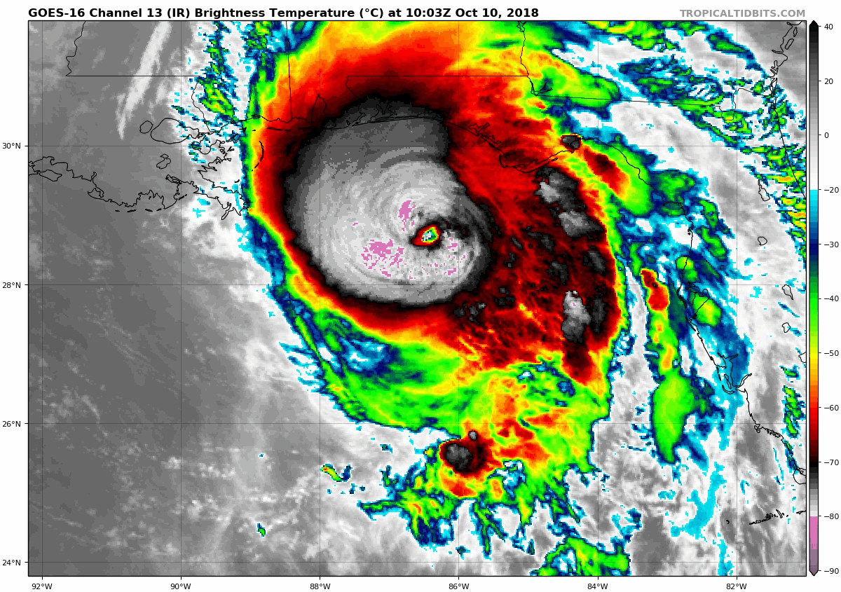
Update 8:15am: The National Hurricane Center says that Michael has strengthened again this morning, with maximum sustained winds now 145mph.
Hurricane Michael strengthened again overnight, and is now approaching the Florida Gulf Coast as a life-threatening Category Four hurricane with maximum sustained winds of 145mph. The National Hurricane Center is now suggesting that the storm will make landfall as a Category Four hurricane with 145 mph sustained winds. No hurricane has ever hit the Florida Panhandle at such a strength. Records date back to 1851.
The strengthening of the storm overnight was feared by many forecasters and meteorologists as early as Tuesday afternoon, when the storm system began to appear more symmetric and approach warmer waters and lower shear. These conditions tend to promote increased organization and strength of tropical systems. The storm was still strengthening as of this morning, with a minimum central pressure down to 937hPa.
Hurricane Michael strengthening this morning.
Michael is expected to bring life-threatening impacts to the Florida Panhandle, particularly along coastal regions from Panama City toward Apalachiola, and even continuing east of there along the south-facing Gulf shores. The National Weather Service is predicting a tremendous rise in water levels, with storm surge values along the shoreline as high as 13 feet above normal – extreme storm surge values that are likely to cause destruction – and 6 to 10 feet along over 300 miles of the Florida Panhandle’s coast.
Powerful winds are also anticipated near the coast of the Florida Panhandle. While hurricane’s powerful winds often do not reach very far inland, the angle of approach from Michael suggests that powerful winds will be transported inland via a “low level jet” or an area of strong winds just above the surface. Wind gusts over 100mph are likely to be common near the coast, causing life-threatening conditions in combination with storm surge and flooding.
Statement from NWS in Tallahassee: #Michael #flwx #Florida pic.twitter.com/OZChdbcgTm
— Bay News 9 Weather (@bn9weather) October 10, 2018
The time for residents to prepare or evacuate is over – and any window to escape with the help of authorities is closing quickly. The National Weather Service in Talahassee, Florida released a statement to residents along the shoreline which their office forecasts for, transcribing a dire message in an attempt to save as many lives as possible. “A potentially catastrophic event is developing”, the wrote in the product, ” Locations may be uninhabitable for weeks or months.”
Major hurricanes that strengthen leading right up to landfall are a nightmare for forecasters, meteorologists and emergency managers. The main focus from this point forward will be making residents in the path of the storm aware of the extreme danger, and doing our best in the final hours to make sure as many people are safe and out of the storms path. Later on Wednesday, the focus will begin to shift to a rescue effort.
Technical Discussion
Hurricane Michael remains an extremely powerful, dangerous, life threatening hurricane this morning and continues to show signs of last minute strengthening as it approaches the Florida Gulf Coast. Powerful convection continues to develop around the storms center – with the only impeding factor currently appearing to be some dry air ingestion in the mid levels. Otherwise, the synoptic environment remains favorable for the storm to maintain intensity right up until landfall.
The latest NHC recon pass noted a close eyewall with multiple vorticies rotating around it, another sign of a powerful, major hurricane. Satellite imagery confirms the storms strength and the temperature gradient became more impressive once again within the eyewall overnight. By all accounts, this is a powerful hurricane that is set to make landfall and cause life-threatening impacts to those in its path.
Wobbles within the storms track are possible over the next few hours and will be tracked carefully to see if they impact the exact landfall location at all. Dangerous impacts from the storm are likely to begin within hours. Stay tuned for further information. This post will be updated today.
Leave a Reply
Want to join the discussion?Feel free to contribute!