-2")
NYC Area Forecast: Cool, transient weather ahead of potential weekend storm
An active and colder weather pattern appears likely to continue for at least the next week, and it may be capped off with a large storm system as its grand finale this coming weekend. The pattern has been well advertised, and it arrived with some fanfare – a few strong cold fronts over the past few days have brought a myriad of hazardous weather to the Northeast states. Sunday featured the first real brisk, cold day in a while with a deep northwesterly flow and even a few lake effect snow/rain bands streaming into the Catskills.
Speaking of cold air, Freeze Warnings and Watches were in effect for fairly large majority of the region through Monday AM where the growing season had not yet ended – for many areas, it has now concluded. If you are in an area where it has not ended, or continue to leave plants outdoors, take care of sensitive vegetation – and yourself (bundle up!) during the next few days.
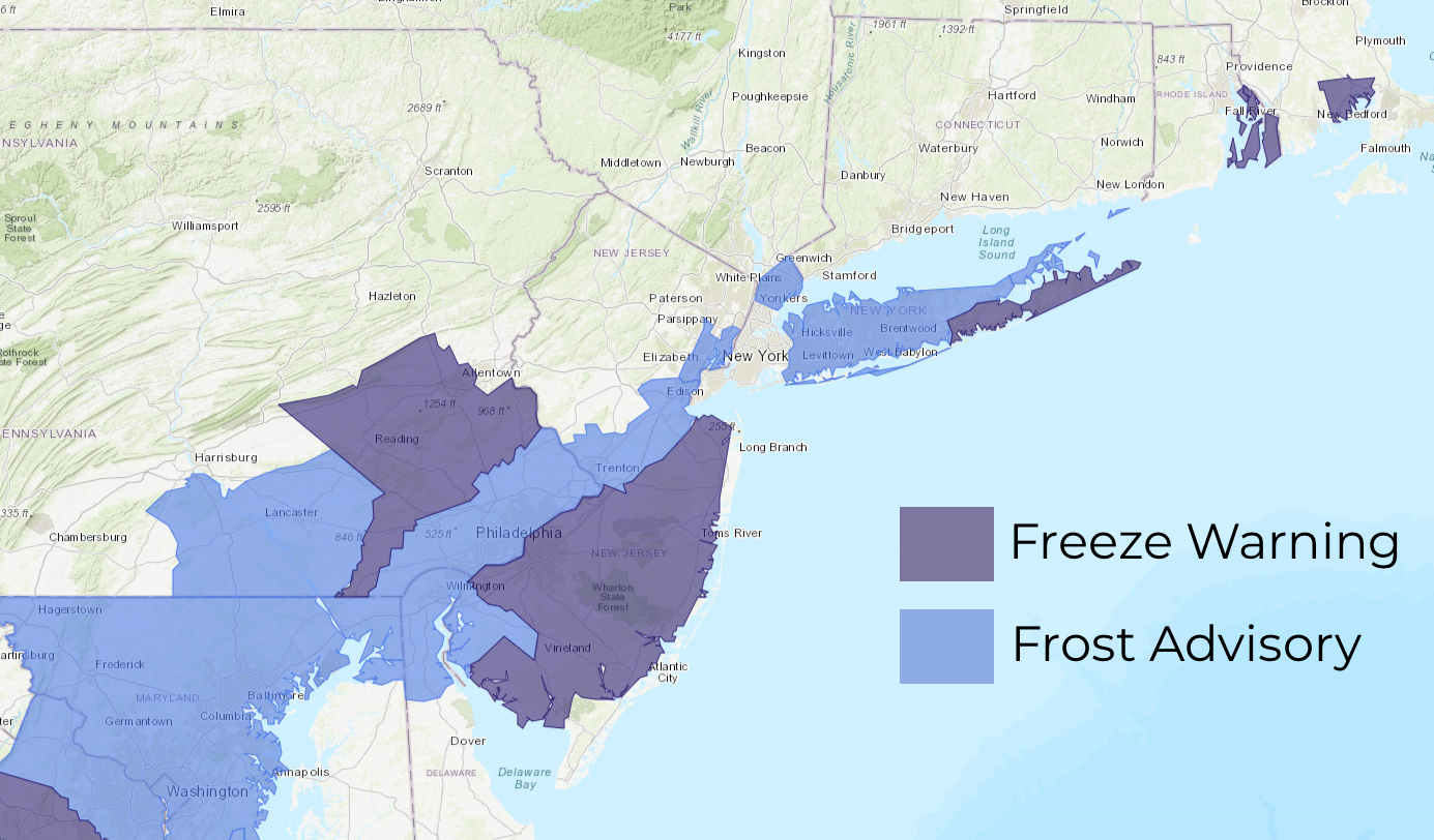
The latest Watches, Warnings and Advisories for the Mid Atlantic and Northeast states – valid through 9am Monday.
After calm and cooler weather continues on Monday, forecast models suggest that another deep trough will dig southward from Canada towards New England by Tuesday. This will result in the development of a low pressure system in the Gulf of Maine by Wednesday morning. The trough has trended deeper and more dynamic over the past 24-48 hours, and forecast model guidance suggests a compact but impressive cyclone may develop there. With the polar-origins of the trough, the potential exists for snow in Maine on Wednesday as the low pressure system strengthens.
As this system blossoms and moves northeastward towards Eastern Canada, the weather pattern through the rest of the Northeast and much of the Mid-Atlantic is expected to remain rather quiet, if not benign. Temperatures will remain cooler than normal, moderating back toward normal by the end of the week, with generally calm conditions. However, what is occurring aloft – including the development of the low pressure in the Gulf of Maine – is offering clues to the potential for a major storm towards the end of the upcoming weekend and perhaps continuing into the early part of next week.
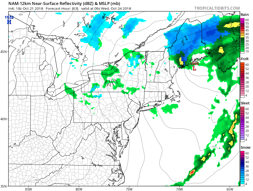
A low pressure system may strengthen in the Gulf of Maine on Wednesday, perhaps producing some snow for Northern Maine.
What’s behind the major storm threat?
Often times, the atmospheric pattern that evolves several days before any potential storm system can give us clues or warning signs as to what is ahead. This time is no different – the signals for a potentially notable storm next weekend are all there. A few days ago, a major ridge developed towards British Columbia, with a poleward reach that disrupted the weather pattern in the higher latitudes of Canada. This sent cold air surging southward and was responsible for todays cold trough – and will be responsible for Wednesday’s potential cyclone development as well. Consider this the first of many warning signs from the pattern evolution.
Next, forecast model guidance suggests that the ridging will build eastward, with higher than normal heights moving towards Central Canada (Hudsons Bay region). While not a traditional “block” per se, the higher than normal/anomalous heights are sufficient to continue to disrupt the high latitude weather pattern, as a disturbance from the Pacific Ocean surges underneath the higher heights and into the United States during the latter part of this week. Finally, the multiple troughs that move through the Northeast this week will be forced to develop into Eastern Canada, transiently sliding through the classic “50/50” position. The amplification of the low pressures in this area helps to slow down the upstream pattern across the United States.
The synoptic pattern progression continues to suggest the potential for a significant Eastern US storm next weekend. A classic predecessor pattern transpires this week, with blocking traversing Central Canada and a non-traditional/transient 50/50 low as well. pic.twitter.com/pqyDoThtmy
— John Homenuk (@jhomenuk) October 21, 2018
With a Pacific disturbance expected to amplify southeastward from the Pacific Northwest, and additional southern stream disturbance Focused near the baroclinic zone off the Southeast Coast, forecast models have begun to suggest the potential for a major storm system in the Eastern US as these two disturbances interact. The synoptic support for this storm system is quite strong, so it is unlikely that this setup is model “fantasy”, despite the fact that the system is still 7 days away.
The exact evolution of the storm system remains uncertain, and will depend heavily on the exact interaction of the incoming disturbances – but the potential for a significant event is higher than normal – with rain and wind both threats as well as high seas from any developing strong low pressure. In the higher elevations, there is the outside possibility that the storm produces an early season snowfall.
Over the next few days, our forecasting team will continue to hone in on the details of this storm and its timing and evolution – so stay tuned for the very latest information. P.S – If you or somebody you know runs a business that depends or is affected by the weather, you should take a look at our Consulting options. They are pretty great.
Leave a Reply
Want to join the discussion?Feel free to contribute!