-2")

NYC Area Forecast: Details on yet another weekend storm
Another series of disturbances is likely to approach the Northeast states this weekend, leading to clouds and the potential for steady rain from Friday into Saturday. Emanating from the Ohio Valley and Mid-Atlantic states, there are actually two distinct disturbances which are expected to move through the Northeast – one on Friday and another on Saturday morning.
Weekend rain has become a trend once again over the past few weeks, with several weekends featuring at least one day “lost” to rain and cloudy conditions in the Northeast states. This weekend will be no different. The saving grace is likely to be Sunday, which is expected to be much more pleasant – at least comparatively.
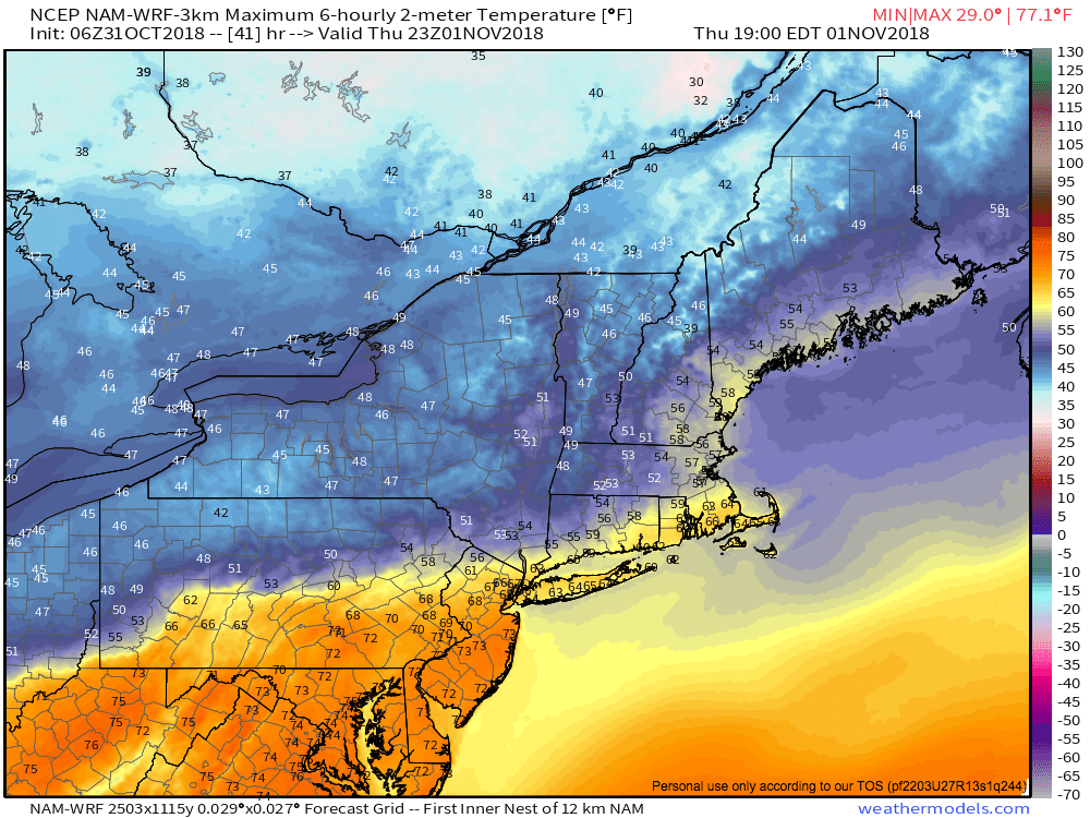
Temperatures will warm up to near 70 F south of a warm front on Thursday.
The first sign of an approaching storm system will actually come on Thursday, as a warm front strengthens and approaches the Northeast states. The front is likely to settle in to the Northern Mid-Atlantic and Southern New England, and will serve as a demarcation line between anomalous warmth and cooler air. In fact, guidance suggest temperatures to the south of the front could very well reach towards 70 F on Thursday – more than 10 degrees above normal for some areas!
After the front becomes established on Thursday, multiple disturbances will begin to advect towards the region from the southwest on Friday. Chances for showers will increase by Friday morning as a low pressure system moves into the interior Northeast and parts of Southeast Canada. By Friday afternoon, building instability in the atmosphere will even allow for a few thunderstorms, some of which could contain very heavy rainfall and some lightning.
After this initial disturbance shifts away from the region, a secondary low pressure area is likely to develop from Friday Night into Saturday. Rain will blossom again throughout the Northeast as lift in the atmosphere increases yet again. A low pressure area will shift northward into the Catskills, with rain likely throughout New England on Saturday morning. Showery conditions could continue into the afternoon on Saturday, but generally improving conditions are expected as the day goes on and the system shifts northward.
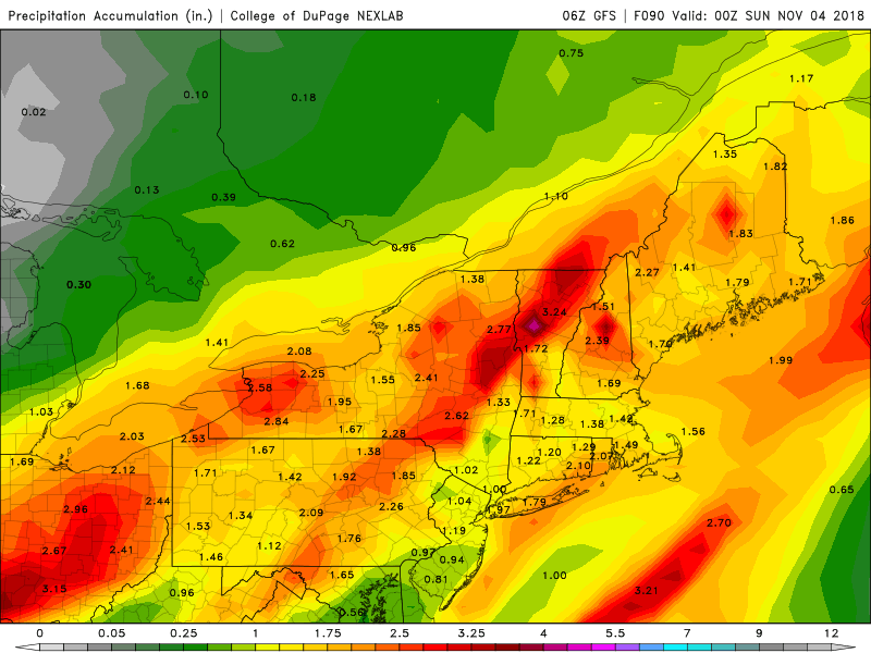
Rainfall totals this weekend are expected to range from 1-2″ across the Northeast.
When all is said and done, between 1-2″ of rainfall is still expected throughout a large part of the Northeast states. These amounts will vary greatly depend on location, and where the bands of heaviest rain set up, but there is good meteorological support for those amounts over a broad area.
Then comes Sunday – unequivocally the winner of the weekend. With both storm systems now off to the north, high pressure will build in to the Northeast States. Much more pleasant conditions are likely, with temperatures near or slightly below normal for this time of year and plenty of sunshine. Our suggestion is to enjoy it – because as the active pattern continues, the next chance of rain won’t be far behind.
Trackbacks & Pingbacks
charles town races
2gateway
Leave a Reply
Want to join the discussion?Feel free to contribute!