-2")
Winter Forecast 2018-2019
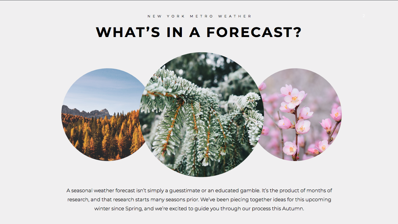
Seasonal weather forecasting, especially when it comes to Winter, is one of the most challenging aspects of meteorology. It isn’t simply a guesstimate or an educated gamble. It is instead the product of months of research which typically begins several months prior. We’ve been piecing together ideas for this upcoming winter since Spring, and we’re excited to present our findings to you. In that respect, we are hopeful to break down the components of the forecast for you.
Instead of focusing on individual numerical indexes and values, we are going to try to paint a picture of the atmosphere and what it will be doing over the next few months – based on several global and hemispheric oscillations, conditions, and phenomena. This will lead us to the conclusions which we believe will be the guiding forces for us during the seasons ahead.
There are three main pieces to a seasonal forecast, and while each year presents a different set of challenges, from a forecasting perspective these three pieces almost always remain engraved in the process. We must look at current conditions, analog years, and forecast guidance for the upcoming months to begin our forecast.
Looking back at the Summer of 2018, an anomalous weather pattern existed across the country. A warmer and wetter than normal pattern generally remained in place across a large majority of the Eastern and Central United States. Parts of the Northeast and Mid-Atlantic observed over 250 % of normal precipitation. The pattern was much drier and warmer in the Intermountain West, Texas and parts of the Southwest United States. The Northern and Central Plains remained cool.
The mid level atmospheric pattern was quite transient and progressive in the Northeast states in particular. While there were a few bouts of heat, the summer was mostly characterized by multiple rainfall and thunderstorm events, with various troughs and cold fronts and continually changing weather. Across the Central United States and Midwest, the pattern was also transient, but more of a gradient existed – the Southern Plains were much drier and warmer than normal.
The role of ENSO and El Nino in the upcoming Winter 2018-2019
Anticipated ENSO Conditions: Weak to Moderate El Nino
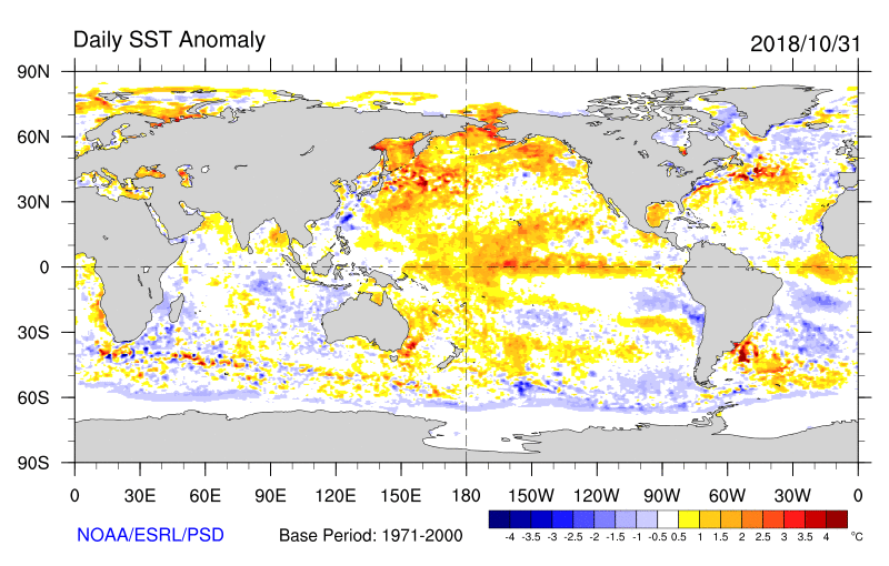
ENSO conditions are one of they key drives to the Winter pattern. “Tropical forcing” refers to concentrated areas of showers and thunderstorms, otherwise referred to as convection, in meteorological regions of the tropics. This convection, most frequently observed in warm and moist climates, releases latent heat that then rises up into the atmosphere, forming ridges of higher atmospheric air pressure.
The equatorial waters of the Pacific ocean that comprise the ENSO regions breed a great deal of convection, which then accordingly results in atmospheric ridging, and subsequently moves downstream, balancing the atmospheric regime. In a general sense, the more anomalous the positive sea surface temperature anomalies, the more convection that can then exert a stronger forcing mechanism on the adjacent regions of the atmosphere, reverberating throughout the globe.
The opposite conditions existed last year, when a Weak La Nina event was present (cooler than normal sea surface temperatures in the equatorial Pacific. This event has completely decayed. El Nino has gradually taken over once again, and the signals for its development can be traced back as far as the Summer of 2018. Subsurface warming and continuously favorable trade winds have supported gradual and continued warming of the equatorial Pacific. The latest subsurface temperature and anomaly maps suggest that warming should continue.
With forecast models continuing to suggest favorable trade winds over the next few weeks – and given the position of the thermocline and degree of subsurface warming – it appears all but certain that a Weak El Nino, at minimum, will develop during the DJF Winter 2018-2019 time frame. It will then be very important to determine whether or not this El Nino will be “Central Based” in nature – or with the majority of its warming in the Central equatorial Pacific. While there is some cooling noted on the latest SST anomalies to the west of South America and Central America, warmer than normal conditions continue near the equator across the basin. Further clarity as to the nature of the El Nino will be an important part of the forecast over the next month or so.
Some clarity on the El Nino’s development and positioning
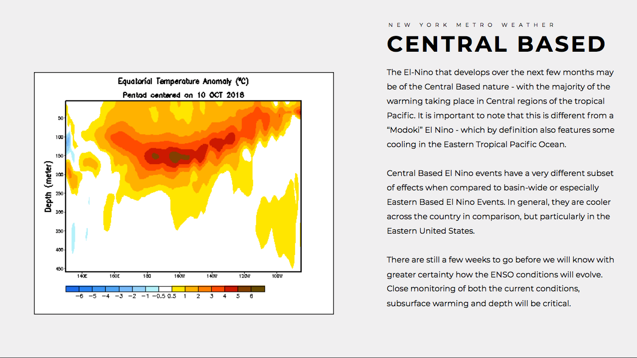
The El-Nino that develops over the next few months may be of the Central Based nature – with the majority of the warming taking place in Central regions of the tropical Pacific. It is important to note that this is different from a “Modoki” El Nino – which by definition also features some cooling in the Eastern Tropical Pacific Ocean.
Central Based El Nino events have a very different subset of effects when compared to basin-wide or especially Eastern Based El Nino Events. In general, they are cooler across the country in comparison, but particularly in the Eastern United States. There are still a few weeks to go before we will know with greater certainty how the ENSO conditions will evolve. Close monitoring of both the current conditions, subsurface warming and depth will be critical.
At the present time, our forecast moderately to heavily favors the development of a Central Based El Nino during the NDJ time frame. This is supported by the subsurface temperatures and thermocline as of the date of this writing. We anticipate weak to moderate Central Based El Nino forcing during the majority of the 2018-2019 Winter. The El Nino may become a basin-wide event by the middle to latter half of the winter.
The Quasi-Biennial Oscillation (QBO) this winter
Prediction: Descending westerly
The QBO has been notably negative and easterly for the past several months, but recently its growth towards a more positive state have been observed. The QBO is a very important atmospheric index which monitors the quasi periodic oscillation between the equatorial zonal wind – from easterlies to westerlies. A negative QBO often supports higher latitude blocking and ridging, while a more positive QBO supports some resistance to high latitude blocking in those areas.
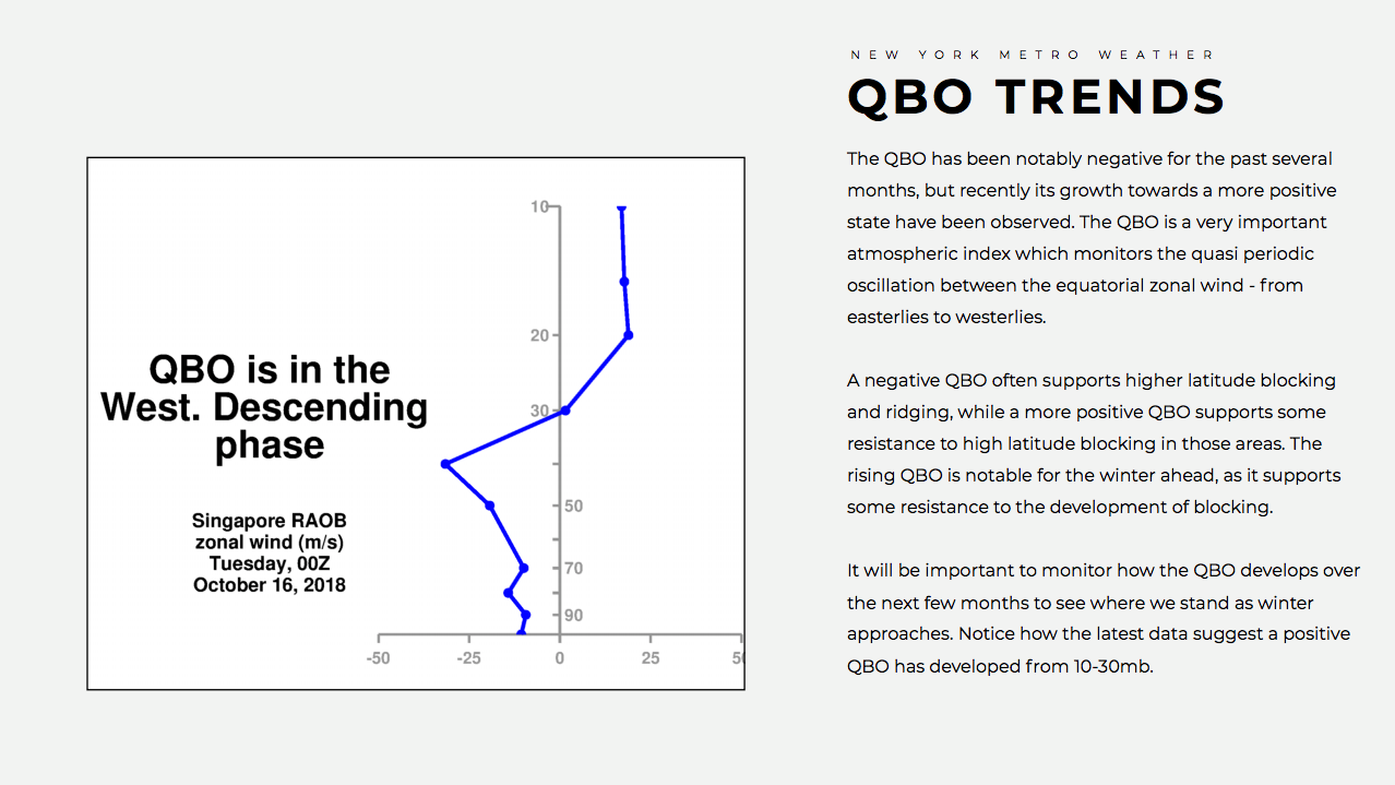
The descending westerly QBO is notable for the winter ahead. The latest analysis suggests that the westerly QBO has descended below 30mb and may be near 40 or 50mb by the time we get into the key months of December, January and February. It will be important to monitor how the QBO develops over the next few months to see where we stand as winter approaches.
Our current forecast calls for a descending westerly QBO, but impacts on the stratosphere are currently expected to be negligible. In other words, we don’t anticipate the QBO having a large affect on the potential for high latitude blocking in one direction or another.
The importance of solar activity during the winter ahead
Solar activity can be a harbinger for the Winter ahead – and while research on its affects on the stratospheric vortex is somewhat limited, solar minimum and maximum periods have been monitored and observed trends in the affects on the high latitude weather pattern. In particular, years that feature lower solar activity or solar minimums – when combined with other favorable hemispheric/stratospheric conditions – can often lead to a weaker stratospheric polar vortex, thus leading to more impressive high latitude blocking.
It is becoming increasingly clear that we are approaching a solar minimum this Winter, and the latest observations continue to confirm that solar activity is at a low point for the past several years. Continued monitoring of solar activity will raise confidence as we approach the Winter ahead, but the current indication suggests that at the very least, solar activity will not have any negative affects on the development of blocking in the higher latitudes, or any affect on the stratospheric polar vortex – barring a wildcard of an intense outburst of solar activity, which can sometimes occur despite a relative minimum period.
Analog years for the upcoming Winter
Years: ’86 – -87, ’94 – ’95, ’02 – ’03, ’14 – ’15


Analog years are an important component to winter forecast development. Looking back to past years that featured similar atmospheric progressions and conditions can offer us a peak into how things may evolve in the winter ahead. We can appropriately weight these based on our understanding of the atmosphere during those years and how it compares to current conditions.
The usage of analog years in a Winter Forecast has been long debated and discussed. How much should a forecaster weigh what happened in the past against what is happening currently? How can we utilize past events when the atmosphere is almost certain to behave differently each time, especially given the difference in global weather when compared with weather events from the 1950’s and 1960’s? The answer lies in forecaster preference, and as is the case with most things, how a forecaster weights and blends different components into the forecast will have a huge impact on the end result.
For us, each winter is different. This year in particular, the number of analog years that fit the set of conditions and the overall progression of the atmosphere is very slim. With that in mind, we decided to weight the analog years in our forecast very carefully, taking only the stronger year(s) and blending quickly downward toward the weaker analogs. We are comfortable with our analog composites that were presented and have factored them into our forecast as we typically do – simply a piece of the larger forecasting puzzle.
Piecing it all together and compiling monthly ideas
When we take the individual pieces of research and compile them into one organized forecast, we can begin to see the ebbs and flows of the winter ahead – as they should be, according to our very best analogs and subset of current and past conditions. This winter, we are confident in our month-to-month composites and have indicated moderate to high confidence on each month.
Below, we break down each months temperature and anticipated precipitation trends. While precipitation maps are not included (lower confidence) we discuss precipitation pattern and potential within each individual months breakdown.
December 2018: Warmer than normal nationally, more precipitation than normal in the Midwest
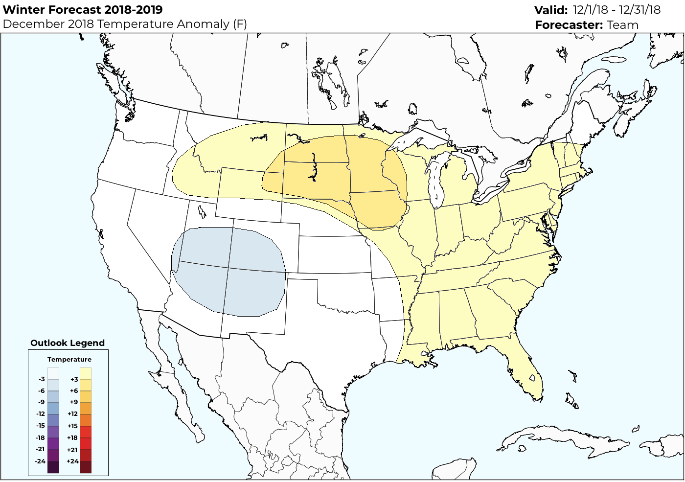
The Winter is expected to begin with the opposite of a “bang” in the Eastern United States. Instead, warmer than normal temperatures are currently favored by all atmospheric indicators, the pattern evolution, and our very best analog composites. Warmer than normal temperatures should be a common theme from the Eastern United States into the Great Lakes.
Warmth is expected across the Northern Plains states, where temperatures may be particularly anomalous from the Dakotas into Minnesota and parts of Iowa. Snowfall is expected to average below normal across these regions to start the winter. Some cooler weather may occur across the Four Corners region into parts of Texas as troughing establishes itself across this area.
Precipitation is expected to average near or slightly below normal in the East and Northeast, while averaging above normal in the Plains and Midwest. This may be particularly true in the Central Plains states, with multiple systems ejecting eastward from the Plains into the Midwest.
January 2019: A transitional month with colder air during the second half of the month
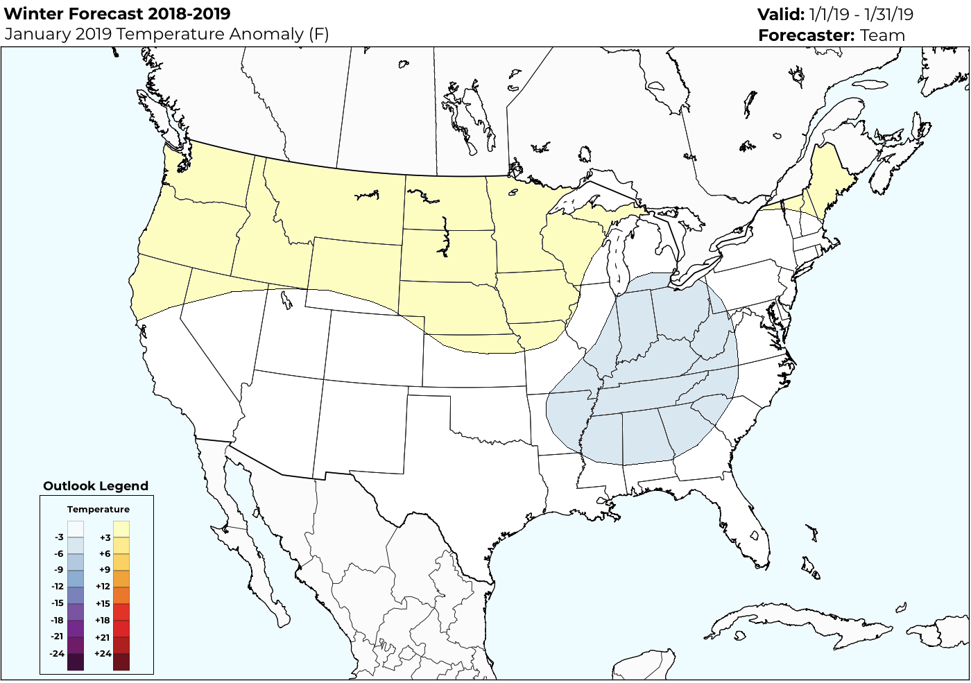
The largest uncertainty of the entire winter exists during this month. The weather pattern is largely expected to transition across the country – with the pattern across the North Pacific Ocean and higher latitudes adjusting dramatically. This shift will gradually promote colder weather across the Central and Eastern United States. It remains to be seen exactly when this shift will occur, how it will occur, and how extreme (or gradual) it will be.
This will obviously have a tremendous impact on multiple forecast interests including energy demand and snowfall amounts/opportunities. Generally, the highest confidence in cold is across the Ohio Valley, while the Eastern Seaboard may not recover from early-month warmth to have a cold month on average. Precipitation from the Midwest to the Northeast should average slightly above normal during this time in those regions, while trending below normal in the Plains and Inter-mountain West.
February 2019: The coldest and snowiest month of the winter, with potential for significant events
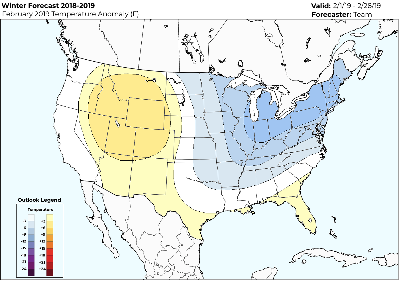
The “boom” month of the winter, February is expected to feature the potential for widespread cold, anomalous in nature, and plenty of snowfall from the Ohio Valley through the Mid Atlantic and Northeast States. Analogs and overall hemispheric pattern evolution indicators are in great agreement regarding the progression. One uncertainty that exists during this month is how far south and how expansive the cold will get.
Our current forecast favors a middle of the ground solution, but some guidance and analogs suggest that periods of very anomalous cold could occur – with outbreaks of polar/arctic air across the Central and Eastern part of the country. Regardless, the month looks colder and snowier than normal across the Eastern United States. Precipitation is also expected to average above normal from the Mississippi River Valley into the Ohio Valley, Southeast, Mid Atlantic, and Northeast.
Across the Midwest and Plains, a temperature gradient will develop – with warmer temperatures across the Plains and Southern Plains (Texas, Oklahoma, etc) and colder and more active conditions in places like Iowa, Missouri and eastward towards the Great Lakes. Again, the potential exists for significant cold during this monthly period.
City by City Breakdown
New York City, NY
Temperatures: Below Normal
Snowfall: Well Above Normal
A colder and much snowier winter than normal is anticipated in New York City.
Boston, MA
Temperatures: Below Normal
Snowfall: Above Normal
A colder and snowier winter than normal is anticipated in Boston.
Philadelphia, PA
Temperatures: Below Normal
Snowfall: Well Above Normal
A colder and much snowier winter than normal is anticipated in Philadelphia.
Washington, DC
Temperatures: Below Normal
Snowfall: Well Above Normal
A colder and much snowier winter than normal is expected in Washington, DC.
Raleigh, NC
Temperatures: Slightly Below Normal
Snowfall: Above Normal
Chicago, IL
Temperatures: Below Normal
Snowfall: Near Normal
A colder than normal winter is anticipated in Chicago, with snowfall near or slightly below normal.
Minneapolis, MN
Temperatures: Near Normal
Snowfall: Near or slightly below normal
A near-normal winter is expected in Minneapolis, with snowfall perhaps averaging a bit below normal.
St. Louis, MO
Temperatures: Near Normal
Snowfall: Near or slightly below normal
A normal winter is anticipated in St. Louis, with temperatures near normal and snowfall slightly below normal.
Fargo, ND
Temperatures: Above Normal
Snowfall: Below normal
A warmer than normal winter is anticipated in Fargo, with temperatures above normal and snowfall below normal.
Denver, CO
Temperatures: Above Normal
Snowfall: Below normal
A warmer than normal winter is anticipated than Denver, but especially in the second half. Snowfall should average slightly below normal.
Dallas, TX
Temperatures: Near Normal
Snowfall: Slightly above normal
A near normal winter is anticipated in Dallas, but a few events may produce snowfall over the average annual amount of 1″.
One Final Note
We wanted to take the time to thank you for reading our 2018-2019 Winter Forecast. The forecast was compiled at New York Metro Weather, LLC in Fanwood, New Jersey from August of 2018 through October of 2018. The graphics were compiled by John Homenuk. Analog work and composition was completed by John Homenuk, Doug Simonian, Ed Vallee and Miguel Pierre. The presentation was compiled and edited by John Homenuk. Additional forecast feedback, commentary and production was provided by Ed Vallee.
Each year, we are fortunate enough to produce and release a Winter Forecast both to clientele and to the public. We are grateful for the opportunity to share our forecast with as many people as we can – and we hope to deliver a forecast that provides detail, information and clarity.
This is amazing. Thank you guys!!