-2")

Confidence rising in a cold, snowier pattern through early December
For the better part of the last two weeks, forecasters in the Eastern United States have slept with one eye open, watching the upcoming weather pattern from late November through early December with a cautious, bated breath. Now, as Thanksgiving approaches, confidence is rising steadily in the ideas we have all been discussing: A colder than normal, and potentially snowier than normal, weather pattern is likely to unfold across the Eastern United States in the next four weeks.
Let’s back up for a moment: Happy Thanksgiving. Thanks for reading our article. Actually, thanks for reading our website at all. This has been one of the most successful years in our websites history, and we owe all of that to each of you who take the time to read what we write every day, or subscribe to our forecasts, or use our forecasts for your business. Thank you. Now lets get into the nitty gritty.
What is causing the change in the weather pattern?
Last week, a major ridge of high pressure developed over Scandinavia. This may seem like a nonsignificant event for those of us in the Central or Eastern United States, but it is quite the opposite. This anomalous ridging, in the higher latitudes of the globe, has begun to retrograde, or move westward against the atmospheric flow.
As it does so, large ridges of high pressure are building concurrently westward toward Iceland and Greenland. This is where it’s time to start paying attention. These ridges of high pressure, or “blocks” are a major feature in our weather, particularly during the Winter months, most notably when they reach key positions to our north like Greenland, Eastern Canada, Davis Strait or Hudson Bay.
Even more significant is the retrograde and the intensity of the ridge itself. Retrograding ridge events emanating from Scandinavia in the troposphere (that’s where we see the majority of our weather unfold) are historically successful in doing one thing: Moving into a position that allows the all-so-important -NAO (North Atlantic Oscillation) to develop.
The evolution of high latitude blocking shows ridging moving from Greenland into Canada.
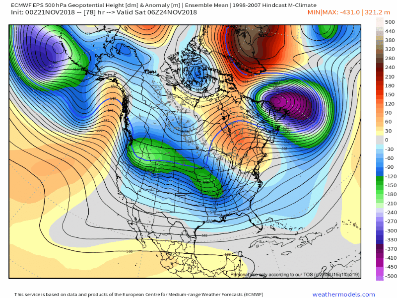
Synoptically, we can watch this process unfold on the latest forecast model guidance, including ensembles. Take a look at the loop above, and watch carefully as a ridge of high pressure moves from Greenland toward Eastern Canada, and eventually past the Davis Strait and into Central Canada. Also watch, as this process unfolds, how deeper troughing builds from the Central United States into the Eastern United States.
You can really start to conceptualize the process here: Blocking ridges of high pressure, like the one being forecast, help to dislodge cold air away from the higher latitude regions in which they typically reside. They also force disturbances underneath them and, for the most part, allow cold air to remain present in areas which these disturbances develop.
As far as the forecasted pattern goes, the writing is on the wall through early December.
What about the Pacific Ocean?
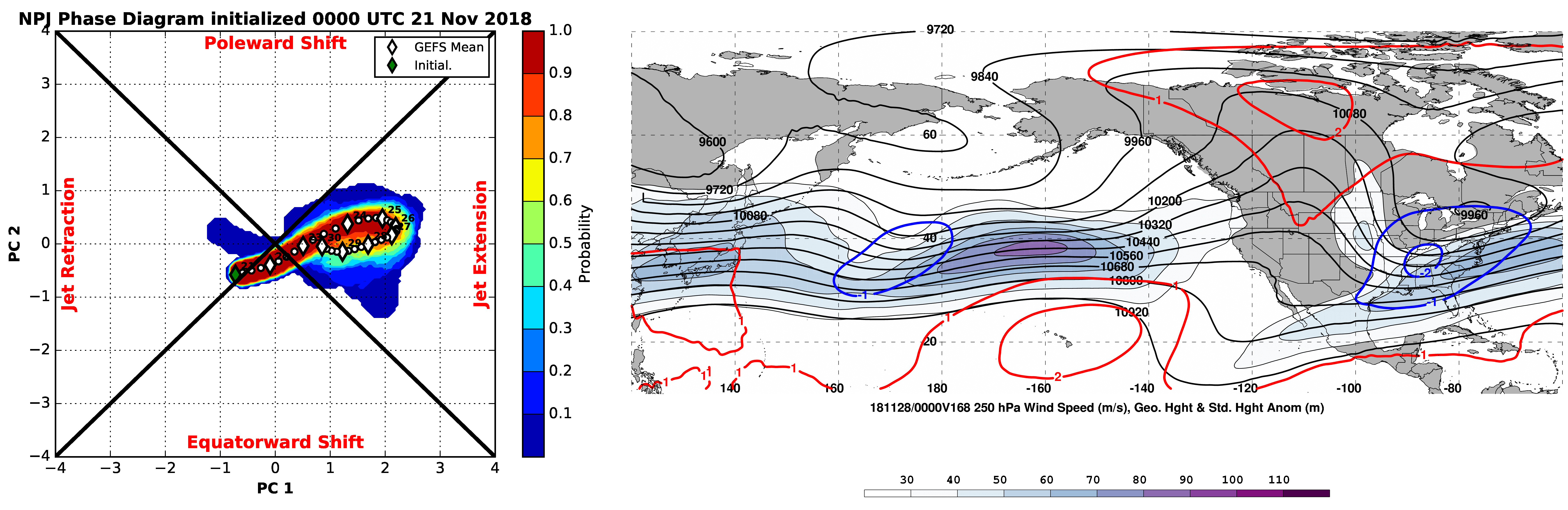
Forecast for the Pacific Jet suggests a jet extension into early December. This could allow for multiple disturbances to shift into the United States.
As we have discussed for quite some time – and we continue to discuss almost constantly in most of our long range products – the balance of power between the Pacific and Atlantic Ocean is one of the major forecasting challenges that we face in the Eastern and Northeastern USA. In the upcoming pattern, the Atlantic Ocean is likely to remain the dominant feature, at least for one to two weeks.
However, the Pacific Ocean will still have an impact on the pattern – and in this case, it appears to be particularly important. While the Atlantic Ocean remains “blocked”, with the development of -NAO heavily favored and cold air likely to be forced southward into the Northeast USA, a jet extension is forecast to develop in the Pacific Ocean.
A jet extension occurs when the Pacific Jet becomes “extended” (shocking) from its typical position. This can do a few things to the weather pattern upstream, but most of the time it allows for an increase in disturbances across the Northern Hemisphere as well as a propensity for Pacific air to make an intrusion into the same region as well.
This Pacific Jet extension is largely being driven by the MJO tropical forcing, which is moving through Phases 8 and 1. As the jet extension amplifies from late November into early December, there is one thing showing up consistently on forecast model guidance: An increase in disturbances moving into the Western United States. In fact, guidance has suggested the development of a “split flow” in the Western USA – with a ridge building from the Pacific Northwest into British Columbia, and Pacific disturbances sliding underneath it into the Four Corners and Southwest USA.
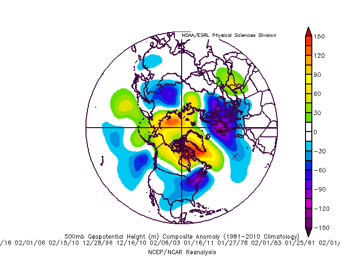
The weather pattern prior to NYC’s 15″ or greater snow events features plentiful high latitude blocking near Greenland – a pattern models suggest will unfold through early December.
What does this all add up to, and what kind of sensible weather pattern can we expect?
At the present time, the pattern being advertised by most reliable forecast model and ensemble guidance reads like this for the Eastern United States: Colder, active, and potentially very wintry through early December.
With retrograding high latitude ridging moving from Greenland into Central Canada, cold air is likely to be displaced southward into Southern Canada, the Great Lakes, and Northeast states. There is excellent agreement amongst the most reliable ensemble guidance in this occurring – although the exact intricate details on how it will evolve remain uncertain.
All the while, the Pacific pattern is expected to become more active, as well. Multiple disturbances may emerge eastward towards the United States, while ridging continues to remain stout into British Columbia/Western Canada. This may allow multiple disturbances to cut “underneath” the blocking ridging into the United States.
With cold air in place, an active pattern with multiple disturbances emerging, and a stout blocking -NAO pattern present on the Atlantic side, the potential exists for multiple significant winter weather events from the Ohio Valley to the East Coast. Exactly how these disturbances evolve remains incredibly uncertain at this range. Does this guarantee anything? Absolutely not – in fact, quite the opposite. It simply means that the potential exists for wintry weather, and that potential appears to be heightened much more than usual.
Over the next few days, our advice is to stay tuned – we are still in the infant stages of analyzing the weather pattern and still are a few days away from even beginning to pin down the dates of potential threats, storm systems, etc.
For weather forecasters, our advice is to get some rest. You’re going to need it.
Trackbacks & Pingbacks
3unforgettable
Leave a Reply
Want to join the discussion?Feel free to contribute!