-2")

NYC Area Forecast: Flash Flood Watch this afternoon and evening
Briefing: A Flash Flood Watch is in effect through tonight. Heavy rain is expected during the evening commute. A colder and active pattern will continue through early December.
Another round of moderate to heavy rainfall is expected this evening, on the heels of a heavy rainfall event that lead to localized flooding on Saturday evening. This system will approach from the Ohio Valley and Great Lakes today, with a secondary low pressure system forming off the New England coast. While not as intense as Saturday’s storm, it will again feature the potential for moderate to heavy rainfall.
With Flash Flood guidance already low from several weeks of above normal rainfall, the National Weather Service has issued a Flash Flood Watch for a large majority of Northern NJ, NYC, Southeast NY and Long Island for the potential for flash flooding, especially in flood prone/low lying areas. Rain is expected to begin during the early afternoon today, first over Eastern PA and Southern NJ, spreading gradually northward.
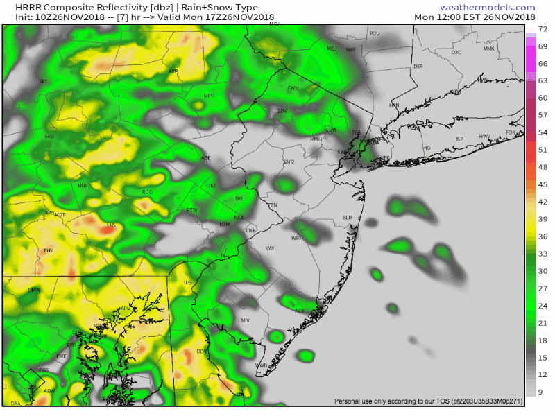
HRRR model suggesting heavy rain this afternoon and evening.
By this evening, rain will become steady and heavy as the secondary low pressure system forms off the coast. Very heavy rain is expected during the PM Commute today, with localized flooding of roadways likely. As a result, expect delays and unusually slow travel during the PM Commute (this includes ground/air travel). Rain will continue until after 6pm before it begins to wrap up from west to east.
The system will eventually push northward into New England, with another winter weather event anticipated for a large majority of Northern New England. It has been a historically good start to the season for many ski resorts, and that is expected to continue, as a very active and very cold pattern continues in those regions.
Speaking of cold, the weather pattern is expected to continue to gradually change in the rest of New England and the Mid Atlantic, as well. Forecast model guidance is in good agreement on the idea that high latitude blocking will continue to traverse Canada and the Arctic regions, dislodging unusually cold air southward into the United States.
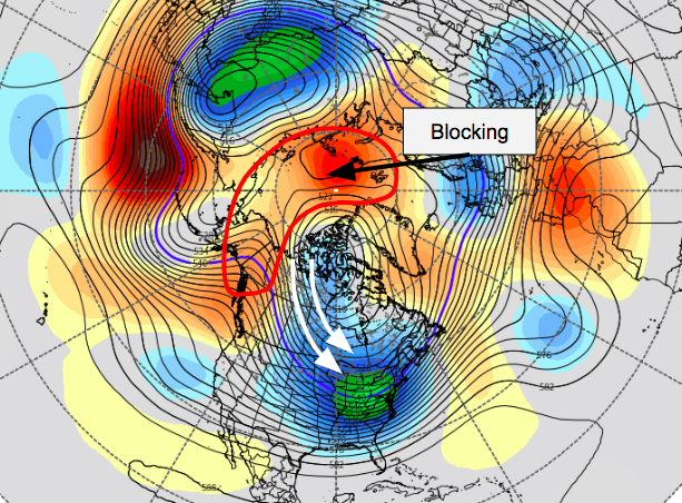
Models suggest the development of an impressive blocking pattern by early December, with cold air surging southward into the USA.
After a brief respite in colder than normal air, centered near the first few days of December, the suggestion is that the arctic flood gates will open up once again. A large ridge building from British Columbia into Canada will send polar air southward, and forecast model guidance suggests temperatures may average 10 or more degrees below normal for several days.
As always, we’ll have more on that – and any potential storms – later today and during the week ahead. For now, have a great Monday morning!
Trackbacks & Pingbacks
3giuseppe
Leave a Reply
Want to join the discussion?Feel free to contribute!