-2")

East Coast winter storm possible this weekend, details remain uncertain
Briefing: The potential exists for a winter storm in the Eastern USA this weekend. Our forecasting team currently favors the storm tracking south of NYC, but we’re closely monitoring and plenty of uncertainty still exists.
Current NYC Hazards Level: Low
For the better part of two weeks, forecasters have discussed the potential for a winter weather event of significance during the first week or so of December, particularly in the Eastern United States. While all has been quiet thus far (one potential storm is heading harmlessly out to sea this week), luck will run out this weekend.
Forecast model guidance suggests that a significant disturbance will emerge from the Pacific Ocean into the Southwestern United States, then tracking eastward towards the Mississippi River Valley. As a low pressure develops in the Southeast States, plenty of cold air will be present across the Mid-Atlantic and Northeast, setting the stage for a potential winter weather event this weekend.
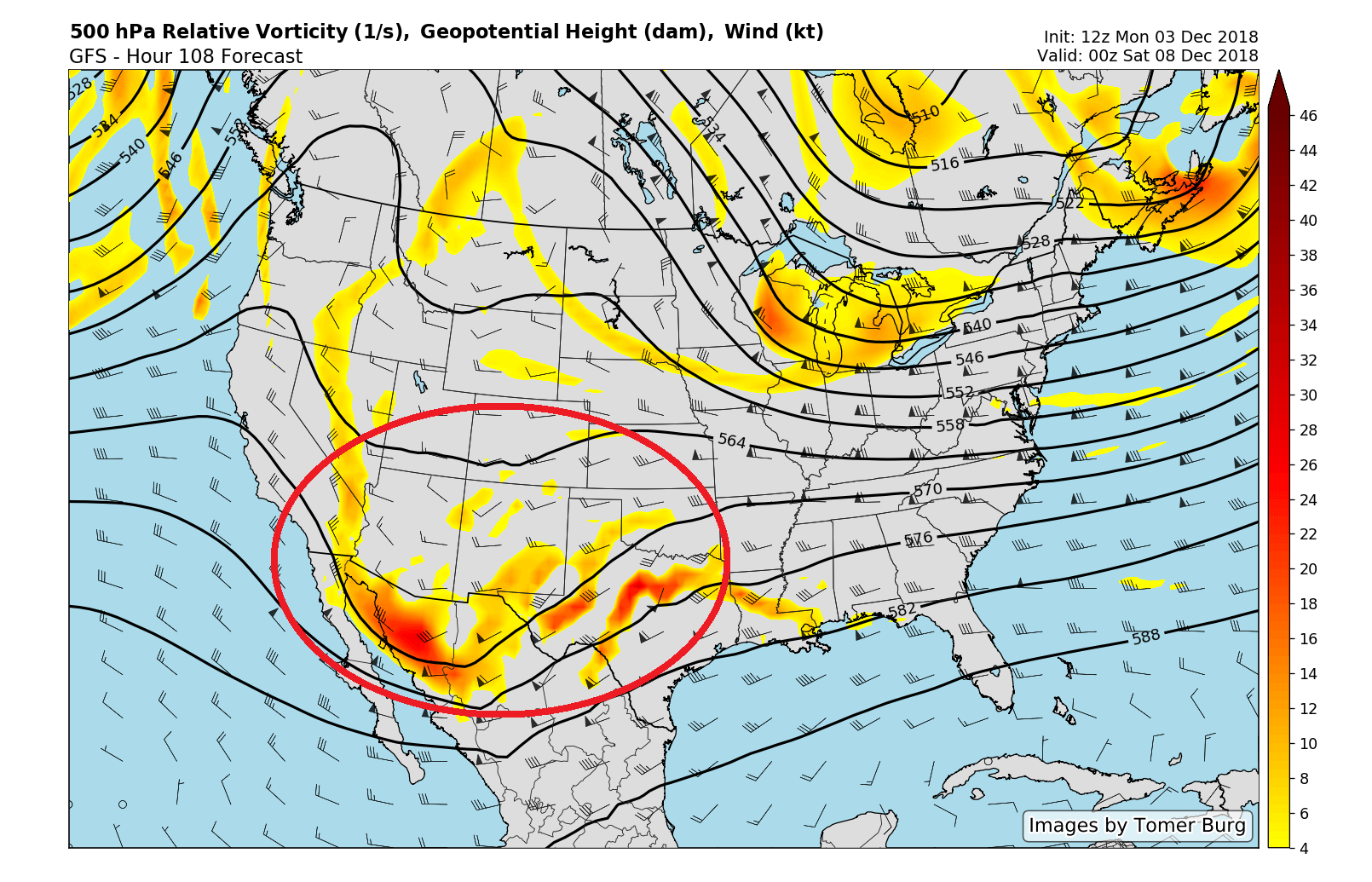
Forecast models suggest the highlighted disturbance will eject eastward towards the East Coast this weekend.
The general evolution of the storm system, as suggested by most forecast model and ensemble guidance at this range, bears a similarity to many other notable winter storms in the Eastern United States from the past. In particular, the disturbance ejecting from the Southwestern United States is forecast to encounter a thermal gradient – or a boundary of differing temperatures – across the Mississippi and Ohio Valleys.
These thermal gradients act to enhance the storm potential, aiding in the strengthening of mid and upper level jet dynamics and allowing the precipitation from the storm to expand, as well as encouraging strengthening of the storm system itself. From a general meteorological perspective, the setup in the atmosphere suggests heightened winter weather potential for the entire East Coast this weekend.
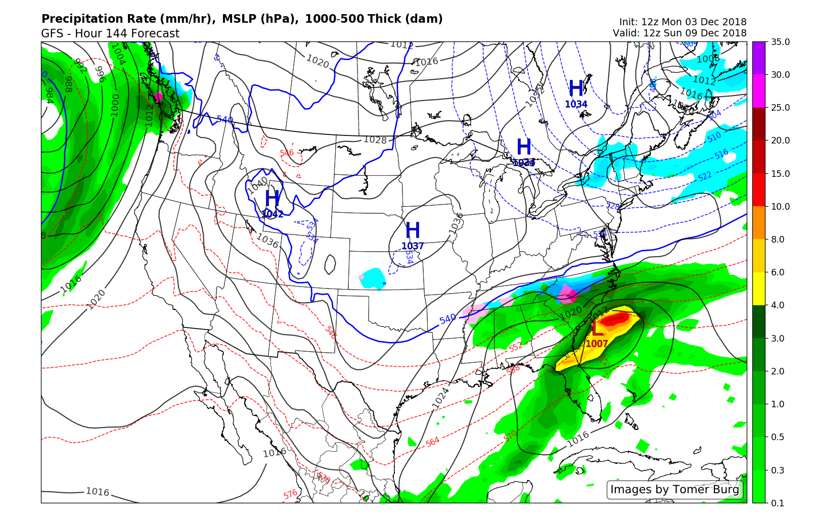
GFS model showing the storm tracking south into the Southern Mid Atlantic.
But as always, the devil is in the details – and the details are uncertain. Forecast model guidance is also in good agreement that the disturbace will encounter strong confluence, or convergence of air, to its north. While confluence itself doesn’t suppress storms, the convergence to the north of a storm system can – and that’s what model guidance suggests will occur this weekend.
As the storm system tracks northward into the Southeast States, the European and GFS models suggest the storm system will encounter a compressed flow over New England, with a disturbance sliding through shortly before the systems arrival. The dry northwesterly winds and mid level flow in the atmosphere force the storm to redevelop further south across the Southeast States and off the Southern Mid-Atlantic shores.
In this scenario, the storm would remain well south of New England, with moderate to significant winter weather impacts in the Southeast States and parts of the Southern Mid Atlantic including the Carolinas. Drier and colder air would remain in place throughout New England this weekend.
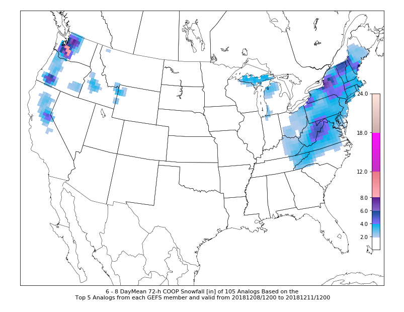
Many analogs from the forecast weather pattern produced snow in the Northeast and Mid Atlantic states.
Uncertainty still exists in regards to the storms track. Historical analogs from the overall weather pattern across the hemisphere suggest the potential for the system to track further north than forecast model guidance currently indicates. In fact, CIPS analog guidance (based on the latest GFS model runs) suggests snowfall potential all the way into New England. A few ensembles, which run as subsets of the major forecast model guidance, suggest the potential for the storm to track further north as well.
Many of the key players which are responsible for the storm threat are still located in the open Pacific Ocean and parts of the Arctic. As a result, confidence in any particular evolution remains quite low. At this time, our forecasting team favors a synoptic evolution that takes the storm south of the NYC Metro Area. However, we suggest continuing to keep a close eye on the forecast as it may change over the next few days.
Current states at highest risk for significant winter weather impacts: KY, NC, SC, VA, WV
Current states at risk for some impactful winter weather, with high uncertainty: MD, DE, PA, NJ, NY
Current states with lowest risk for impactful winter weather: NH, VT, ME, MA, CT, RI
Leave a Reply
Want to join the discussion?Feel free to contribute!