-2")

NYC Area Forecast: Updates on snow threats
Briefing: Bands of snow may impact isolated parts of Eastern NJ on Wednesday, and a larger coastal storm passes to our south later this weekend. Impacts are currently expected to be negligible in NYC for both – but uncertainty on the weekend storm system remains high.
Dry, calm and cold weather has settled in to the Northeast states today, and is expected to generally remain in place through the middle of the week. The forecast remains extremely interesting and highly convoluted, however, as multiple disturbances will pass by the Northeast states.
The larger focus will be on the system this weekend, and rightfully so, but a prior system – which passes off the NJ Coast on Wednesday – may have some tricks up its sleeve.
Inverted trough trickery on Wednesday
With deep cold in place, forecast models suggest a weak disturbance will pass underneath the Northeast states on Wednesday. The system is expected to remain largely weak, progressive and strung-out as it crosses the Northeast.
However, it will develop into a stronger and more cohesive area of low pressure from later Wednesday into Thursday out in the Western Atlantic Ocean. While mostly harmless and non-impactful, the orientation of the developing trough and storm system creates the potential for an inverted trough.
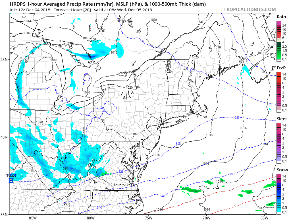
Some forecast model guidance indicates the development of an inverted trough, and associated snow bands over NJ on Wednesday.
Inverted troughs are areas of lower pressures and lower heights that extend away from the main area low pressure. These occur more often in the Gulf of Maine and in New England, there deeper troughs typically track. The lift near the inverted troughs can create bands of snow (or rain) that sit over one area for an extended period of time.
Forecast models have been hinting at the potential for exactly this on Wednesday, with an inverted trough extended back westward towards the New Jersey coast. With steep lapse rates and plentiful lift in the lower levels of the atmosphere, bands of snow could develop in Eastern NJ. The main issue on forecast models is whether or not moisture will be sufficient for these bands to be steady, and not just sporadic.
At the present time, we are favoring a solution where a few inches of snow are possible across Eastern NJ – specifically in parts of Ocean and Monomouth counties during the afternoon hours. These bands of snow (perhaps mixed with rain at the coast) could cause travel delays in these areas.
The rest of the region is expected to remain cold and dry through the weekend
A larger storm system and a close call to the south
As mentioned for the past several days, the potential for a larger and more expansive storm system exists this weekend. Forecast model guidance has been shifting around with this system as whole, but the general synoptic evolution has remained the same – a disturbance ejects from the Four Corners and moves towards the Southeast US.
With plentiful moisture and jet dynamics, the system should strengthen and produce a very impressive area of precipitation from the Southeast United States into the Southern Mid Atlantic. The question then comes how far north the system can move.
Today, the ECMWF, GFS and CMC models (As well as most of their ensembles) suggest the impacts from the storm system will largely be relegated to areas south of NJ/NYC. However, with the mid/upper level evolution of the storm still shifting around, we aren’t out of the woods yet.

Forecast model guidance suggests a strong storm develops over the Southeast later this week – but then heads seaward as it encounters resistance to the north.
A few ensemble members, and our best analog matches to the current pattern, suggest that we be wary of a north trend with this storm system as it approaches. This is particularly impactful to the forecast in areas like Washington, DC – where a northward trend would mean significant impacts.
The major uncertainty stems from deep cold and compressed atmospheric heights over New England. Most forecast models suggest that these will stay strong and suppress the storm to the south, while a few others suggest it will lift out and allow the storm some room to move northward and impact areas like Philadelphia and New York City.
Regardless, we’ll be keeping a close eye on it over the next few days, but our current forecast still continues to favor the worst impacts south of New York City.
Current states at highest risk for significant winter weather impacts: KY, NC, SC, VA, WV
Current states at risk for some impactful winter weather, with high uncertainty: MD, DE, PA, NJ, NY
Current states with lowest risk for impactful winter weather: NH, VT, ME, MA, CT, RI
Leave a Reply
Want to join the discussion?Feel free to contribute!