-2")
Light Mix Tonight, Unsettled Pattern Remains In Place
Good evening!
Well it may be a new year, but we are certainly stuck in the same old pattern that we have been entrenched in since the beginning of December. A decaying high pressure system to our north is currently moving off the coast of New England, which has allowed for a more mild and moist airmass to overspread the Mid-Atlantic and much of the Northeast. Clouds have been on the increase for virtually the entire day, and the combination of increasing clouds and mid-level flow switching over to the southwest has allowed for temperatures to rise into the upper 30’s to lower 40’s this afternoon. While still generally “cool”, these temperatures are anywhere from 5-10 degrees above normal for early January.
Cloudiness will continue to increase throughout the rest of this evening and into the overnight hours as a weak shortwave trough approaches the Northeast from the Great Lakes. Temperatures will be falling tonight, but the increasing cloudiness will put a cap on just how low they can fall tonight. Precipitation from the weak area of low pressure approaching the New York City metro will likely begin as a light snow/rain mix by 11pm-1am, but should quickly turn to all rain for the vast majority of the area. Locations that have the best chance at staying mostly (light) snow through the overnight hours will be elevated locations that are off to the north and west of the immediate New York City area.
Regardless, this system will be moving very quickly to the east this evening/overnight, which will severely limit how much moisture from the south is able to interact with it. Even those who manage to stay 100% frozen tonight will only see a half-inch of snow at best–most of which will be erased as precip quickly shuts off from west to east before dawn.
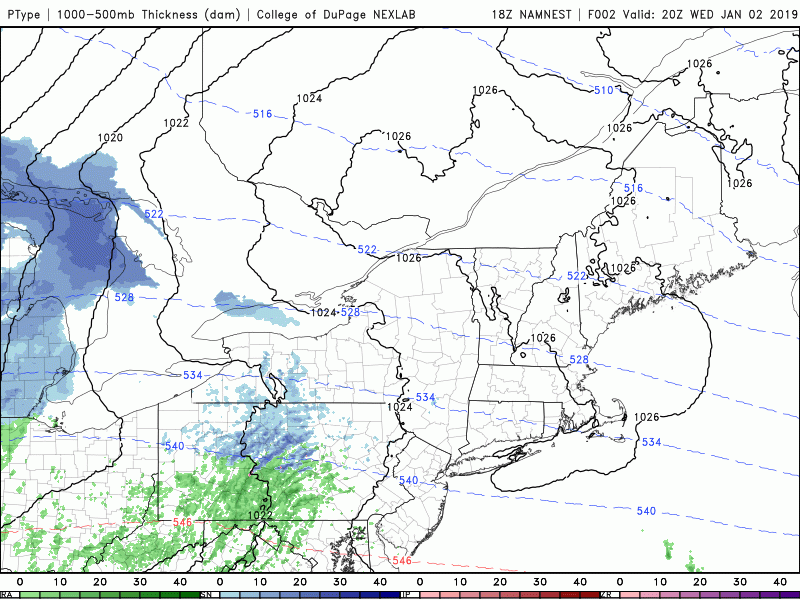
This evenings high-resolution NAM model showing the evolution of the quick-hitting system this evening/overnight
Yet Another Rainstorm Likely on Saturday
As mentioned, the area of low pressure impacting our area through the overnight hours and into the early morning hours of Thursday will be quickly moving off the coast by the AM commute. As this system departs, any remaining precipitation over the Northeast will come to an end by the early afternoon hours. Partly cloudy skies with breezy conditions will be prevalent tomorrow afternoon, with temperatures remaining in the middle to upper 40’s. Our next system will remain off to the south long enough to allow for calm conditions to persist through the evening and overnight hours tomorrow night. Clear skies and gradually subsiding winds will allow for radiational cooling to set up, which will cause temperatures to drop into the middle to upper 20’s across the entire forecast area.
Conditions will remain calm and clear into Friday as surface high pressure quickly moves to our south during the day. This will cause dry and mild weather for the majority of the day, with temperatures once again staying in or around the middle 40’s. The weak surface high pressure will then quickly exit off the coast by Friday afternoon, which should set the stage for a cut-off upper level low to gradually move into the Mid-Atlantic states on Friday evening. Cloudiness will slowly increase from north to south Friday night, with showers developing over portions of Southern New Jersey by 8-10pm. This slow-moving system will not have any cold air to work with as precipitation moves to the north, so this entire storm will be another wet and mild system.
As the upper-level low continues to edge in over the Mid-Atlantic during the early morning hours on Saturday, surface low pressure will begin to intensify off to our south. This will result in another impressive low-level jet overspreading the NYC metro area, with more steady rain developing by the late morning/afternoon hours on Saturday. The surface low should then take on a more easterly course during the day, likely moving off the NJ coast during the afternoon hours. Steady rainfall will continue into the evening, before gradually tapering off from west to east Saturday night. Though the exact amounts and timing will still need to be tweaked over the coming days, this looks to be another dreary and inconvenient weekend storm opposed to anything truly impactful-outside the potential for some coastal flooding.
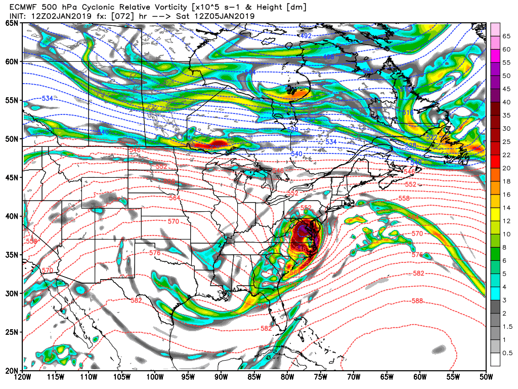
This afternoons ECMWF model showing a compact closed low over the Mid-Atlantic on Saturday morning
Unsettled Conditions Last Through Next Week
An active northern stream jet will allow for another disorganized shortwave to move through the Northern Plains states on Monday and into the Great Lakes by Monday night. While there may be some blocking over Greenland at this time to allow the system to slow down a bit and organize before impacting our area, there is still no real cold air source anywhere outside of New England and Southern Canada. This afternoons model runs have been rather consistent in showing the possibility of some front-end mixed precipitation for our area overnight Monday, before a changeover to rain Tuesday morning as the surface low tracks over the Lower Hudson Valley.
At this time the overall potential for impactful winter weather looks to be low for the NYC area, with an increasing chance once you get into New England. It is important to note that this system is still five to six days out and there are many details that need to be ironed out. We will continue to update you over the next couple of days on this potential system!
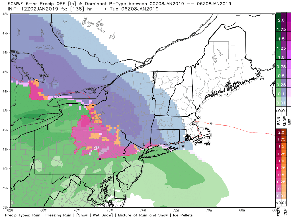
PM European model showing the potential for some wintry weather over portions of the Northeast Monday night/Tuesday
Have a great night!
Steve Copertino
Leave a Reply
Want to join the discussion?Feel free to contribute!