-2")
Mid-Atlantic Snow, Cold Weather Holds Tight Into Next Week
Good Evening!
We have finally seen the return of more seasonable temperatures across much of the Mid-Atlantic and Northeast today as an Arctic high pressure system continues to dominate our sensible weather. Temperatures early this morning were in the teens to lower 20’s across much of the NYC metro area, which really brought a harsh reminder to many that we are still in the middle of January and it does get cold-despite the past few weeks of warmer temperatures. As we worked through the day today, temperatures were only able to rise into the middle to upper 20’s with some lower 30’s closer to the coast and over portions of Southern New Jersey-which is right around normal or just slightly below-normal for this time of year.
Continued clear skies and dry conditions will last well into the evening and overnight hours tonight which will set the stage for near-ideal radiational cooling conditions to take place. Temperatures will likely plummet once again back down into the teens for much of the forecast area, with lower to middle 20’s for portions of Southern New Jersey. Even with subsiding winds into the overnight hours, windchills will still be quite low-with readings likely getting down into the lower teens and single-digits over NNJ, SNY, and Connecticut!
Needless to say, if you’re planning on heading out tonight, remember to bundle up!
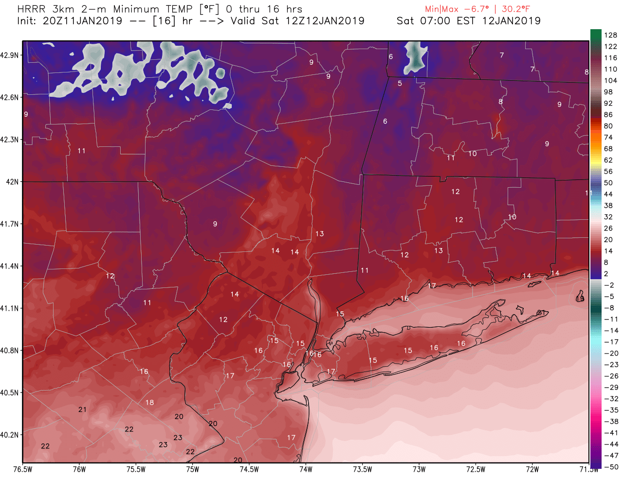
This evenings HRRR model showing the predicted low temperatures for this evening and into the early morning hours tomorrow
Snowstorm Takes Aim at the Mid-Atlantic
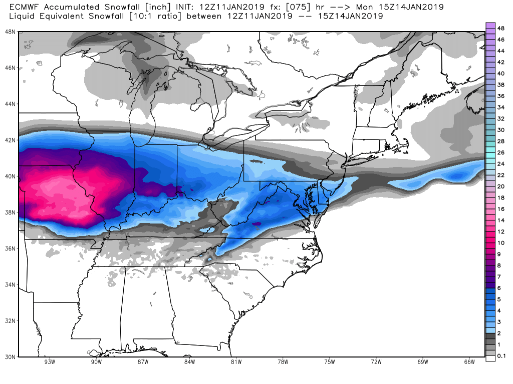
The system we have been discussing for the better part of a week now is well underway across portions of the Midwest this evening where up to 12-18″ of snow will be possible by Sunday morning over portions of Missouri.
As this system continues to head east over the next 24 hours, it will begin to become more disorganized and strung-out due to an upper level system over Canada gradually pressing down onto it and increasing the speed of the flow out ahead of this storm. While light to moderate snow will continue to spread east over portions of the Midwest and Ohio Valley through tomorrow afternoon and into the evening hours, it will continue to feel the effects of this Canadian system.
This will cause precipitation to become more light in nature once it reaches the Mid-Atlantic states late Saturday night. An impressive 1040 mb high pressure system will be located over Southern Canada as this storm heads towards the Mid-Atlantic, which will essentially guarantee that precipitation will be in the form of snow. This strong high pressure system will also help keep the vast majority of the steady snow well to the south of the NYC area during the morning/afternoon hours of Sunday.
Locations to the south of NYC could possibly see some marginal/light impacts from the northern-fringe of this system, with a general coating to two inches possible to the south and east of Philadelphia. Locations from Philadelphia to New York City have may see some brief and very light snow during the day on Sunday, but any accumulation potential seems extremely limited at this time.
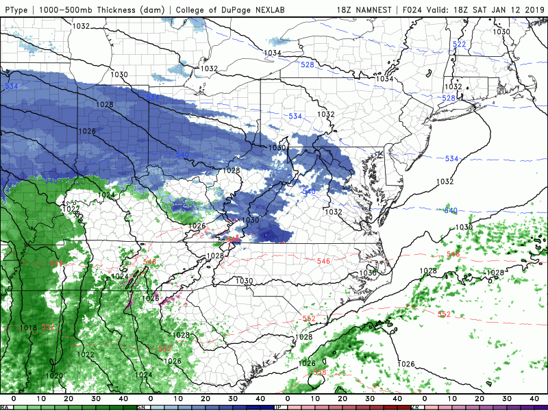
This evenings high-resolution NAM model showing the evolution of the Mid-Atlantic snowstorm this weekend
Cold and Clear Conditions Dominate New Week…More Active Times Ahead?
High pressure will once again take control as this weekends storm gradually moves off the Mid-Atlantic coast on Monday, which will usher in a new round of cold and calm conditions. Temperatures for the majority of the week next week will be right around normal or just below-normal, with highs in the middle to upper 30’s. Though we are relatively far out at this point in time, we may see a frontal system approach the area late next week around Friday that may provide our next shot at some wintry precipitation.
Our attention then shifts towards next weekend as most of the reliable models and their respective ensembles show a growing threat for a sizable storm system to impact the eastern half of the country. While the overall synoptic pattern will be in the process of transitioning to a more favorable one for snow, there are signals showing up that would lend some support to this overall idea of a heightened storm potential next weekend. Since we are nearly ten days away still, we cannot nail down any specifics at this time other than the fact that we will likely need to closely monitor the pattern next week to see how this increasingly interesting period unfolds!
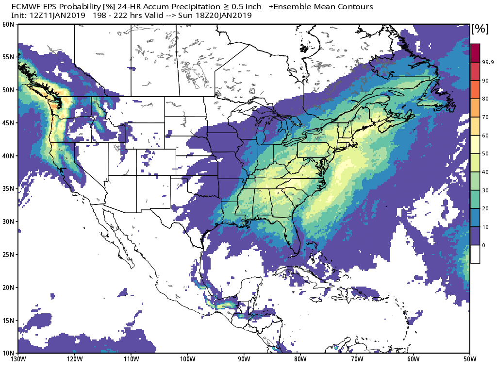
The ECMWF ensembles showing a heightened potential for a potential storm system the East Coast next weekend
Thanks for reading and we’ll have an update on Monday!
Have a great weekend!
-Steve Copertino
Leave a Reply
Want to join the discussion?Feel free to contribute!