Multi-faceted winter storm to impact the region this weekend
Highlights: After light snow today, a more notable winter storm approaches for the weekend, with arctic air moving in behind it and a colder and active weather pattern to follow.
Good Evening!
Today has been a rather gloomy and cold January day across much of the Northeast as the weak system that dropped some light snow across portions of the metro area this morning continues to quickly head offshore. As discussed in previous updates, this system was likely to only produce a trace to one inch of snow over the area, and that is exactly what has been reported as of this afternoon.
As the snow departed late this morning, mainly cloudy conditions remained overhead with mid level flow increasing out of the southwest. These southwesterly winds have allowed for a slightly more marginal airmass to overspread the area today. Coupled with the persistent cloudy conditions, this caused highs today to rise into the middle to upper 30’s across much of the forecast area-with 40’s reported closer to the coast. Cloudy and slightly above-normal temperatures will continue into the evening hours before a mid level disturbance passes well to our north. This system will be accompanied by a cold front that should help to clear out some of the remaining clouds tonight and usher in colder temperatures from our northwest.
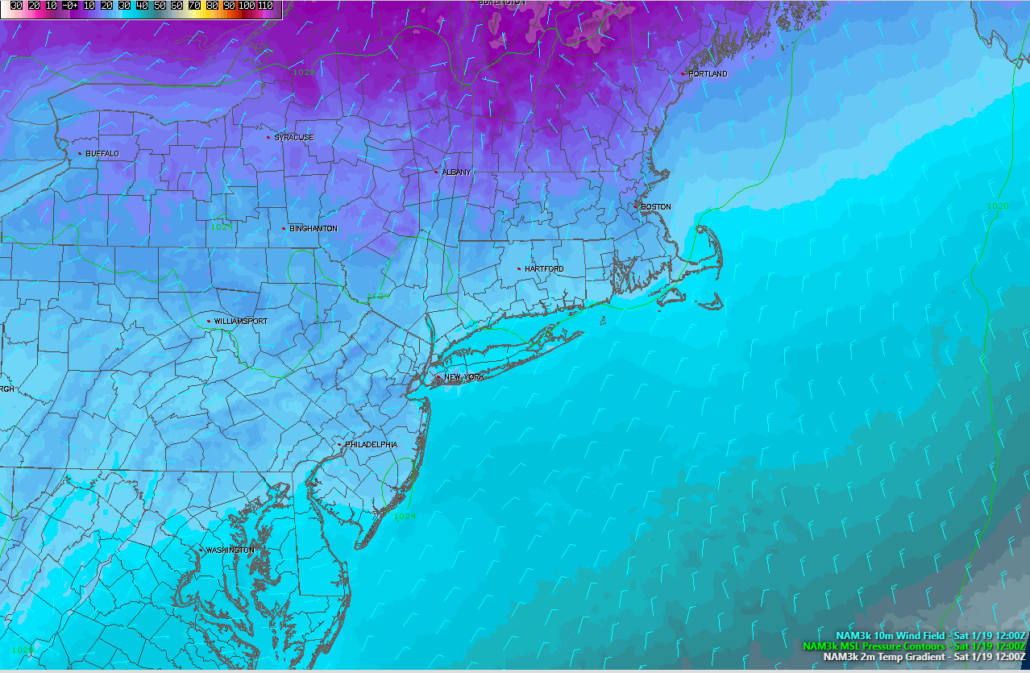
Lows will likely drop back down into the lower to middle 20’s for the majority of the area this evening, which will be right around normal for this time of year.

This evenings high resolution NAM model showing lows backing down into the 20’s and lower 30’s for the NYC area
Complex and Impactful Winter Storm This Weekend
While tomorrow (Saturday) will likely start off quite calm and clear, the winter storm we have been talking about for nearly ten days now will be quickly approaching from the west. By 8 am, the storm will be centered over the Tennessee valley, with moderate to heavy snow expanding into much of the Ohio Valley. While the main shortwave trough associated with this system will not be able to completely interact or phase with the larger system over Canada, it does appear that there will be just enough of an interaction to keep the bulk of the heavy snow well off to the north and west of the immediate NYC area.
As we head into Saturday afternoon, the surface low over the Tennessee valley will be picking up steam and intensifying. As it does so, a large area of warm/moist air will begin to stream northward over much of the Southeastern states. All of this warm and moist air just above the surface will collide with a strong Arctic high pressure system over southern Canada and cause a moderate to heavy band of snow to develop over portions of New York and Pennsylvania. Light snow will likely begin to move into portions of Eastern New Jersey by 3-4 pm, with the snow quickly picking up in intensity over time. This band will continue to head east by 4-5 pm, likely overspreading the entire metro area by that time. All of the warm/moist air moving into the Northeast and colliding with colder air to the north will cause an enhanced area of lift within this band of snow, which could push snowfall rates into the 1-2″ per hour range–especially over portions of EPA, SNY, and NW NJ.
This area of moderate to occasionally heavy snow will likely continue into the evening hours of Saturday. It is at this time that precipitation types will start to become an issue. Due to the SW to NE orientation of this system thanks to the modest interaction with the system located over Canada, warmer air in the lower levels of the atmosphere will begin to overspread much of Southern and Central New Jersey, and eventually into the immediate NYC area. While the overall track of this system and the actual degree of interaction with the aforementioned Canadian system will determine the timing of this changeover, much of the metro area will likely see a change to a mix of sleet, freezing rain, and plain rain by 11 pm to 1 am. Locations off to the north and west of the immediate NYC area could potentially hold onto pure snow few a few more hours, causing a steep snowfall gradient to develop over our area.
Warm/moist air will continue to push further north into the forecast area overnight on Saturday and into the early morning hours of Sunday. Locations around the immediate New York City area have a good chance to flip to all rain at this time, with locations to the north and west potentially changing over to a dangerous mix of sleet and freeing rain. In fact, the freezing rain threat will be quite high over this area, with up to a tenth to a quarter of an inch of freezing rain possibly falling by Sunday morning.
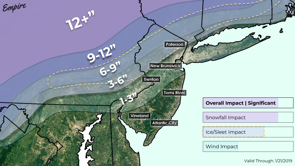
The combination of moderate to heavy snow and freezing rain will likely cause very significant travel disruptions north and west of the city on Sunday morning.

Our latest total snowfall accumulation map for Saturday and into Sunday morning. The hatched area denotes the potential for significant freezing rain and sleet accumulations.
Dangerous Flash Freeze Possible Sunday and into Monday
Precipitation will likely still be ongoing by 8 am Sunday morning, with rain mostly expected for the vast majority of the forecast area as the surface low pressure system will likely be over Southern New Jersey at this time. Despite the change to plain rain, much colder air will be quickly approaching the area as the surface low begins to pull to our east during the afternoon hours on Sunday. Temperatures will quickly fall well-below freezing and into the lower to middle 20’s from west to east, likely causing any standing water to refreeze. Any residual precipitation over the area will need to monitored, as a flip to snow would be possible.
Regardless, true Arctic air will work blast through the entire forecast area by Sunday night, with lows dropping down into the single-digits! Winds will also be quite strong behind this system, with gusts up to 35 mph possible. If significant ice accumulations do occur over portions of the area, then there could be an enhanced threat of power outages Sunday night.
The colder than normal weather pattern is very likely to remain in place into next week, as a piece of the polar vortex fractures and settles in to the north of the region. This will keep cold and potentially active weather in the forecast as we move toward the back half of the week, and especially into next weekend.
We will Continue to provide updates on this storm over the next day or so. Please stay tuned to our social media accounts for up to the minute information!
Thanks for reading!
-Steven Copertino/John Homenuk

Trackbacks & Pingbacks
3sumatra
Leave a Reply
Want to join the discussion?Feel free to contribute!