-2")
Major cold expected next week as Polar Vortex returns
The polar vortex, which paid us a quick visit just this past Monday, is expected to make its triumphant return to the United States next week. This time, it will be more organized, stronger, and bring with it a large swath of abnormal and potentially record-breaking cold.
The polar vortex, as a whole, remains one of the most misunderstood (and overhyped) features in meteorology. You may recall the last time the term Polar Vortex went “viral”, back in 2014. It was a media frenzy – the polar vortex was coming to invade the United States and we were all going to be taken away with it.
You may also recall the reality of it – it was cold, and in some places it was snowy – and anomalously so. The truth is that the polar vortex is not unheard of, or unthinkable. It is, however, a very neat atmospheric feature, and it deserves our full attention. It affects the weather greatly, and its positioning and intensity throughout the Winter months is a critical component of many forecasts.
This coming polar vortex event appears increasingly impressive as it approaches. After a stratospheric warming event in early January, which split the polar vortex at the stratospheric level (way above our heads), the polar vortex is now starting to split and fracture in the troposphere as well (that’s where we experience most of our weather).
What is the polar vortex?
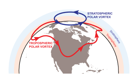
The Polar Vortex, in our hemisphere, is a persistent cyclone that is typically located near the North Pole. It features a counter-clockwise rotating pool of cold, dense air — some of the coldest on the globe. An increased temperature gradient between the mid and polar latitudes strengthens the vortex during the winter season. The vortex moves around to a certain extent, but generally remains in the vicinity of the poles for most of the year. In the troposphere (where we experience most of our weather) the polar vortex can often fracture, and pieces that separate and move away from the pole can bring anomalous weather (often very cold air) to areas that don’t normally experience it.
The strength of the polar vortex can fluctuate in both the troposphere and the stratosphere. In a very general sense, a stronger polar vortex tends to stay closer to its home near the pole. It can often become a behemoth of sorts, difficult to move around and with a strong upper level jet stream around it. When it weakens, however, the vortex can become much more “wavy” and move around quite a bit. Warming near the vortex or disruptions near the vortex in the stratosphere and troposphere can cause pieces of it to move far away from its typical location.
Polar Vortex Comparison, Darryn W. Waugh, Adam H. Sobel, and Lorenzo M. Polvani, 2016.
What is the stratospheric aspect of the polar vortex, and why is it important?
The stratosphere, while not part of the direct/sensible weather we observe every day, has an important role in meteorology. The term polar vortex is most often used to describe the planetary circumpolar vortex. The polar vortex discussed in news media is more often referencing the tropospheric polar vortex, which exists in the troposphere where most of our sensible weather occurs. The stratospheric polar vortex exists at its most notable strength from Autumn to the end of Winter, and is much smaller in size than the polar vortex in the troposphere.
The stratospheric polar vortex is quite important. While a separate entity from the polar vortex that impacts our weather on a direct basis, its strength and positioning can have major implications on our weather. The stratosphere and troposphere often work together, especially when they are directly coupled, and changes in the strength and positioning of the stratospheric polar vortex can lead to major changes in the troposphere as well.
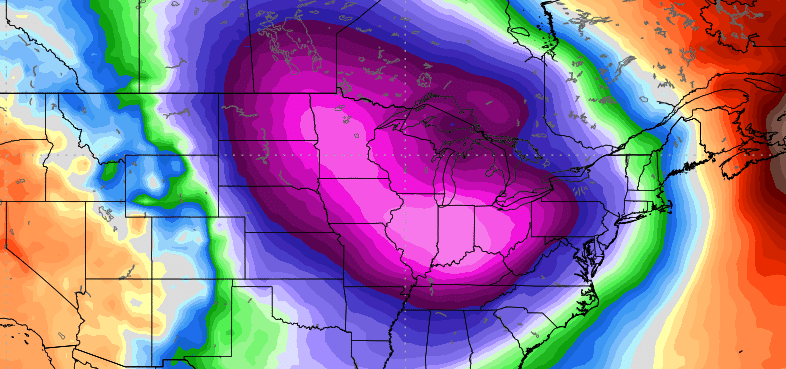
The weather pattern in place over the next several days will promote the splitting and southward movement of a major piece of the polar vortex. In fact, it will even partially phase with another disturbance over the Mississippi River Valley, helping to tug it south further. As it surges southward into the Plains and Great Lakes, it will bring pure arctic air with it.
The latest ensemble guidance suggests that temperatures and heights from 500mb (mid levels of the atmosphere) to the surface (where we live) could approach record low levels in parts of the Plains, Great Lakes, Ohio Valley and perhaps Interior Northeast. Polar and arctic air is expected to come surging southward, leading to the potential for extreme cold in those regions.
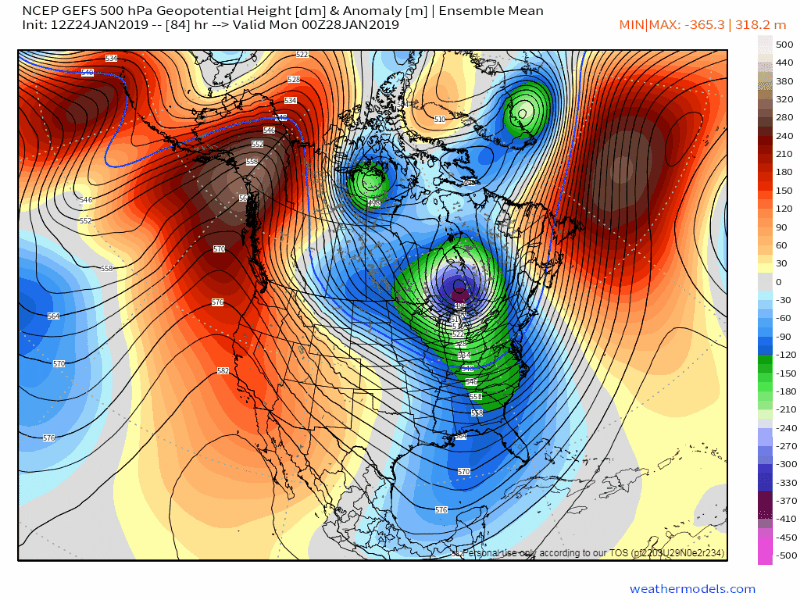
GEFS model showing the PV dropping southward into the United States next week.
What does this mean for our area in terms of actual weather?
As the polar vortex sinks southward into the Plains – perhaps delivering record breaking cold – the polar air will begin to shift eastward into the Ohio Valley and then the Northeast. It will modify to its surroundings as it does so, so we aren’t exactly expecting temperatures 30 degrees below zero in New York City.
However, with the polar vortex moving quite quickly into the region, the potential exists for an arctic front – with blustery winds and some snow – followed by bitter cold, potentially some of the coldest of the winter. Next Wednesday and Thursday could be particularly brutal as the polar vortex meanders over the Northeast states.
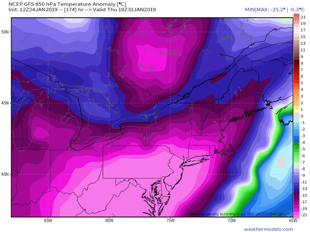
Temperatures at 850hPa may reach record low levels by next Thursday
As is the case for all things, the polar vortex will also pass – returning from whence it came by the latter part of next week and then the weekend. It is at that point that we will begin looking out for winter storm threats, with bitter arctic cold to our north, and the atmosphere opening up the door for more impactful disturbances and moisture to approach.
Have a question about the polar vortex? Submit it to us via our Contact Form or social media and we will answer it in our article this week!
Leave a Reply
Want to join the discussion?Feel free to contribute!