Light snow likely Tuesday, frigid conditions arrive Thursday
Good evening!
Today has been a rather calm and seasonably cold day across much of the Northeast as a weak area of high pressure located to our north remains in control of our sensible weather. Spotty upper level clouds associated with a quick-moving shortwave trough moved through the southern portions of the area earlier this morning and into the afternoon hours, but quickly gave way to mostly sunny skies. Mostly clear skies and residual northwesterly flow aloft allowed highs this afternoon to stay in the upper 20’s to lower 30’s-with the vast majority of the region staying below freezing. High pressure to our north is expected to quickly move to the east through this evening and into the overnight hours. Surface flow will gradually begin to shift from the north/west, to a more southerly/southeasterly component during the overnight hours, which will help to increase cloudiness over the area. Overnight temperatures will likely be able to fall a few degrees, with readings likely staying in the lower to middle 20’s for the majority of the immediate NYC area.
Light Snow Likely North and West of NYC Tuesday
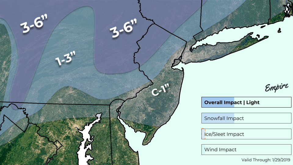
Our attention shifts to the Great Lakes region by tomorrow morning as an area of mixed precipitation along a cold front will be moving quickly to the east towards our area. The overall setup has become much less impressive since our last update, with only light snow accumulations expected well to the north and west of the immediate NYC area. Surface winds tomorrow morning will be out of the south and east, which will help to warm temperatures into the lower to middle 30’s all the way into NE NJ and SE CT. While precipitation may start off as a mix of light rain and snow for most of the area, a quick transition to a cold rain is expected for all locations outside of elevated portions of Northern New Jersey and the Lower Hudson Valley.
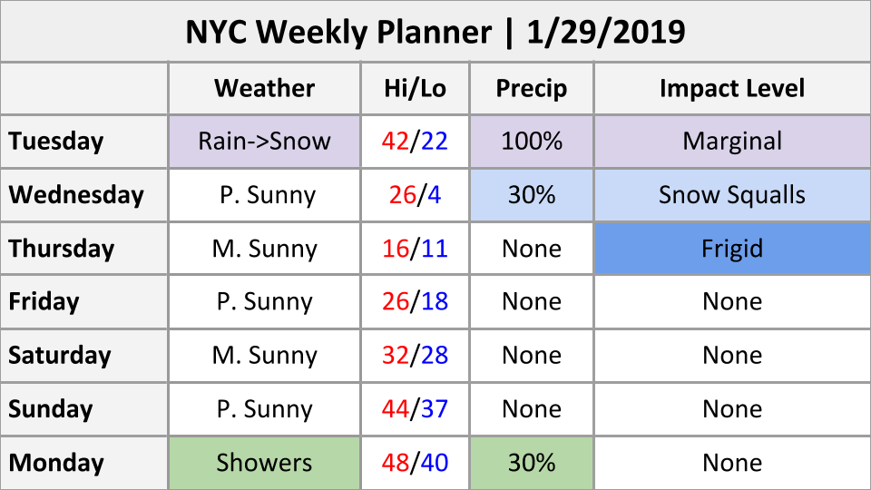
Precipitation will remain predominately light to occasionally moderate in nature into the evening hours before the front begins to move across the area. We may see an increase in precipitation rates as warmer air coming in from the coast interacts with the cold/dense incoming Arctic airmass off to our west. This could create a narrow band moderate snow that moves from west to east over the area, possibly producing a quick coating to an inch all the way down to the coast as temperatures quickly fall below freezing. Precipitation will quickly end from west to east during the very early morning hours of Wednesday with the main impacts from this system primarily being felt well off to the north and west of the NYC area.
Conditions behind the cold front will be quite blustery on Tuesday night, with wind gusts potentially getting into the 30-40 mph range as temperatures drop into the lower 20’s and upper teens. The rapidly falling temperatures and gusty winds will create the potential for any residual standing water to quickly freeze on untreated surfaces-possibly creating some hazardous travel conditions.

Our latest impact map for the light mix event tomorrow. The main impacts from this system will primarily be felt well off to the north and west of the city
Frigid Arctic Air Arrives Thursday
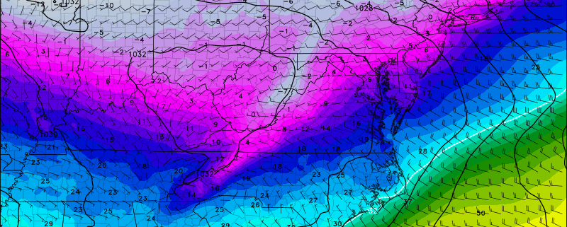
The long-awaited “polar vortex” will be located just to the north of the Great Lakes by Wednesday morning, with very deep westerly flow overspreading the Northeast. The cold front associated with the weak surface low to our north will be exiting off the coast Wednesday morning just in time for the AM commute, allowing for gradually clearing skies. While the airmass behind this first front will be quite cold, the main Arctic front will wait until the afternoon hours of Wednesday to work its way into the NYC area. Southerly flow at the surface will overspread the NYC area ahead of the main Arctic cold front, allowing for temperatures to rise into the lower to middle 20’s Wednesday afternoon.
The aforementioned deep westerly flow directly associated with the strong tropospheric vortex to our west will cause mid level temperatures to plummet over the Northeast before surface temperatures have a chance to respond. This will create impressive “lapse rates” (change in temperature with height) Wednesday afternoon over the majority of our area. Furthermore, some weak mid level energy will be edging into portions of the Mid-Atlantic and Northeast during Wednesday afternoon. This setup will create the potential for some snow squalls to develop and quickly move from west to east around 12pm -4pm on Wednesday. Some of these squalls could be quite heavy in nature, producing very low visibilities at times and potentially dropping a quick coating to an inch for some locations. The Arctic front will finally blast through the NYC area during the late afternoon and early evening hours of Wednesday. Winds will quickly increase to around 20-30 mph, with gusts up to 40 mph as overnight low temperatures rapidly fall into the single digits across the entire forecast area–with temperatures likely falling below zero for elevated locations off to the north and west.
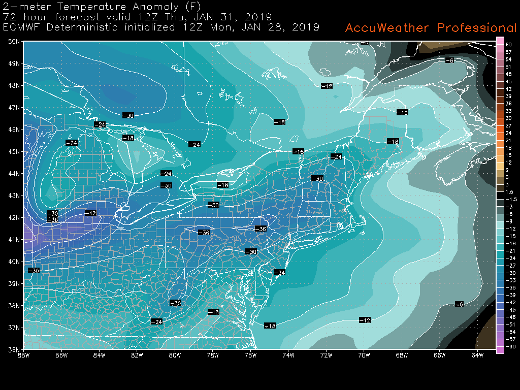
Thursday will be one of the coldest days of this winter season as highs struggle to make it out of the lower to middle teens for virtually the entire Northeast. Highs will be anywhere from 20-35 degrees below normal across the Northeast Thursday afternoon-which may wind up breaking a few records across the region. Wind chills will also be extremely cold, with readings likely anywhere from 10-20 degrees below zero by Thursday morning. Frigid and calm conditions will continue into the evening/overnight hours of Thursday, with lows in the single digits over the entire area.
Temperatures will moderate a bit on Friday, with highs likely getting back into the lower to middle 20’s, before a more significant warm up takes place later on this weekend.

ECMWF model showing surface temperatures anywhere from 24-36 degrees below normal on Thursday morning (AccuWx)
We’ll have an update on this Arctic airmass as well as a look at this weekend’s weather on Wednesday!
Have a great night!
-Steve Copertino


Leave a Reply
Want to join the discussion?Feel free to contribute!