-2")
Updated: Mild and calm conditions turn unsettled later this week
Good evening!
The short-lived, but intense blast of Arctic air last week is now all but a memory as an area of mid-level ridging continues to build over much of the East Coast.
Mild and calm conditions turn unsettled by Wednesday
Tuesday morning will likely feature some patchy fog and low clouds over portions of the NYC area for the AM commute with temperatures in the middle 30’s to lower 40’s. The fog and associated low level clouds should then quickly burn off as winds shift to the southwest. These southwesterly winds ahead of an approaching cold front will help to bring in spring-like temperatures once again, with highs likely reaching into the upper 50’s to lower 60’s across most of the immediate NYC metro area. Portions of coastal Long Island and Connecticut may have a tougher time getting out of the middle 40’s as cooler winds from the Atlantic remain in place. A weak and rather dry cold front will pass through the Northeast late Tuesday afternoon and into the evening hours, with a dry westerly flow developing aloft. Clear and seasonably cool conditions will be in place Tuesday night, with lows likely dipping back into the middle 20’s to lower 30’s.
Westerly flow aloft will continue over much of the Northeast on Wednesday as another area of mid-level ridging develops overhead. Conditions should remain rather calm and clear during the first half of the day before the mid level ridge axis shifts off to our east. This will provide a more southerly component to the mid level flow, which should gradually increase low-level moisture in across much of the East. Highs will likely remain in the lower to middle 40’s on Wednesday as skies become increasingly cloudy during the late afternoon hours as a weak area of low pressure develops off to our west. This area of low pressure will move to our south during the evening hours of Wednesday, likely producing an area of steady rain that impacts the region by the evening and into the overnight hours.
There is a chance that some cold air from the north is able to drain into the northern sections of the forecast area, producing some light freezing rain Wednesday night. Temperatures ahead of this system will be quite marginal, but we will have to monitor this potential solution closely over the next 48 hours.
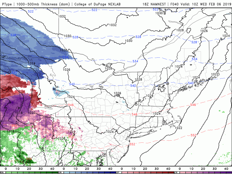
This evening’s high resolution NAM model showing the development of rain, and even a chance at some freezing rain Wednesday night across the area
Unsettled conditions look to close out the week
As discussed last week, a series of low pressure systems look to cut well off to our north and west over the Northern Plains and Great Lakes by the later half of this week. This will put the Northeast firmly within the “warm sector” for all of these systems, which means that continued above normal temperatures are likely to end the week. Spotty rain showers will be possible on Thursday, with another chance at some rain by Friday morning/afternoon as a cold front works through the East. Despite the multiple chances at some rain, the threat for any significant rain is quite unlikely at this time.
Conditions may turn seasonably cool and relatively calm for this weekend as a large area of high pressure dives into the Plains and makes it’s way east. Early indications are that this are of high pressure should remain in control for the vast majority of this weekend before another Pacific shortwave trough moves into the area by early next week-likely providing our next chance at some precipitation.
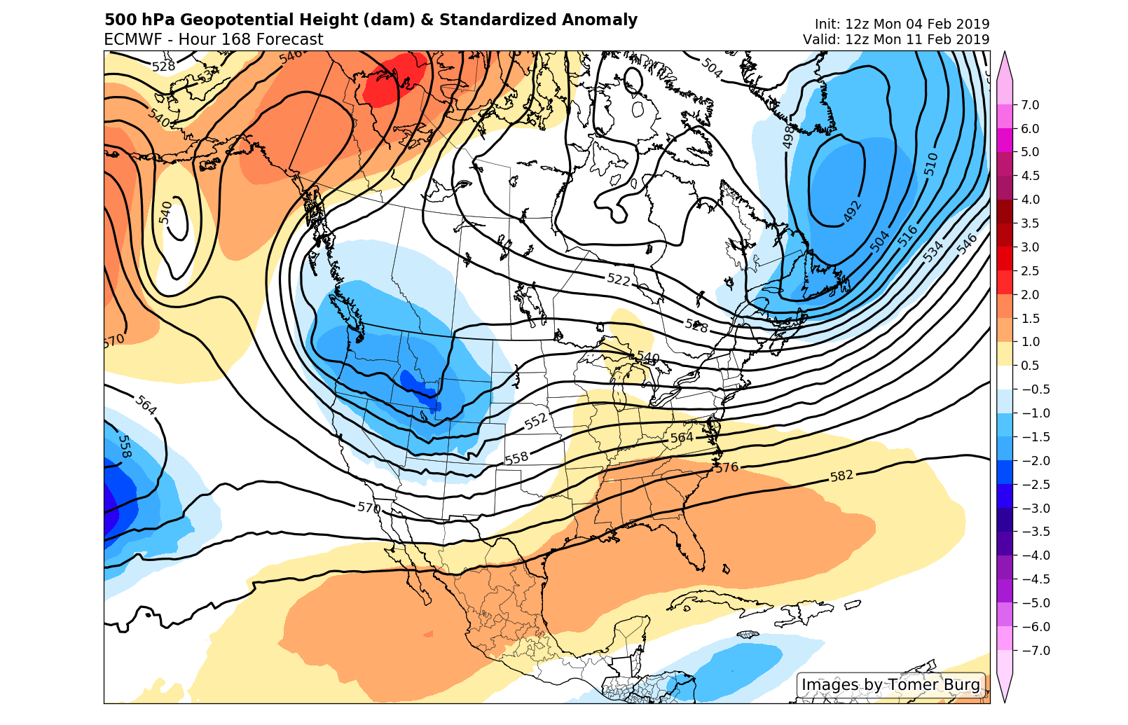
This afternoon’s ECMWF model showing the pattern of a trough in the west and a ridge over the SE lasting into early next week
We’ll have an update on this week’s rain/interior mix threat by Wednesday!
Have a great night!
Steve Copertino
Trackbacks & Pingbacks
2checked
Leave a Reply
Want to join the discussion?Feel free to contribute!