-2")

Wintry weather potential increases next week
Good evening and happy Friday!
Conditions have improved substantially across much of the Northeast this Friday afternoon as a rather weak cold front cleared out any remaining cloudy & unsettled conditions.
High temperatures this afternoon were able to rise back into the upper 40’s to lower 50’s across much of the New York City metro area thanks to mostly clear skies and relatively mild mid level temperatures. A steep pressure gradient has developed over the Northeast today thanks to an area of low pressure over Canada and a strong area of high pressure diving into the Plains. This has left us with rather gusty winds in the wake of the cold front, with much of the area seeing gusts in the 30-35 mph range. These gusty winds will continue into the late evening and overnight hours as the colder air behind the cold front finally works it’s way into the region. Temperatures tonight will fall considerably, with lower to middle teens expected in and around the immediate NYC area. Elevated locations off to the north and west of the city can expect lows to drop back down into the middle to upper teens, which will once again be below normal.
The combination of continued gusty winds and temperatures in the teens and 20’s will make for some rather cold wind chills readings tonight, with single digits expected for the entire forecast area. With all of this in mind, definitely make sure to wear some layers if you’re planning on being outside tonight!
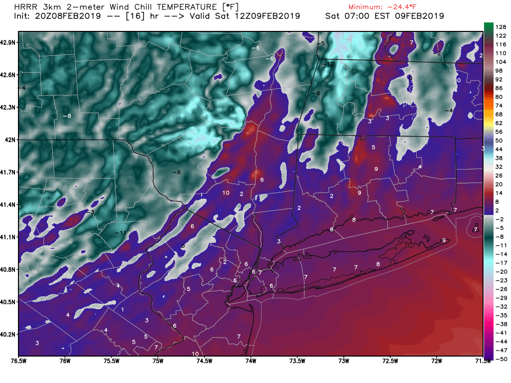
HRRR model showing wind chill values close to zero for much of the NYC area by early Saturday morning
Dry and cold weekend likely
This weekend will start off quite cold tomorrow (Saturday) as temperatures likely struggle to break the freezing mark for much of the NYC area and locations off to the north and west. Occasionally gusty winds will still be likely through at least the afternoon hours of Saturday before the pressure gradient finally diminishes. Calm and cold conditions are expected for the remainder of the day as high pressure builds into the region by the evening. Strong northwesterly flow aloft will be in place tomorrow evening, and this should help inject another round of dry mid level cold air into the region. This cold and dry airmass will set the stage for some modest radiational cooling to take place Saturday night, with temperature likely falling well into the teens for the entire NYC area. The immediate NYC area should see lows drop into the 15-19F degree range, with 10-15F likely off into portions of Northern New Jersey.
Sunday will be another calm and relatively cool day as high pressure moves through the Mid-Atlantic and Northeast. The only significant differences on Sunday will be that an area of mid level ridging will be moving off the Southeast during the afternoon hours, switching mid level winds to a more southwesterly component. This will bring in a very slight increase in surface temperatures to the area, with highs likely staying in the middle to upper 30’s. A very weak and disorganized system will be moving through the Ohio Valley late Sunday night, which may cause some areas of very light snow to develop over portions of the Mid-Atlantic states.
Some light snow may try and make it’s way into our area by the very early morning hours of Monday, but it appears that the locations with the best potential to see some flakes in the air will be over southern New Jersey. This system will also be moving at a rather brisk pace, so no significant impacts are expected for the AM commute on Monday.
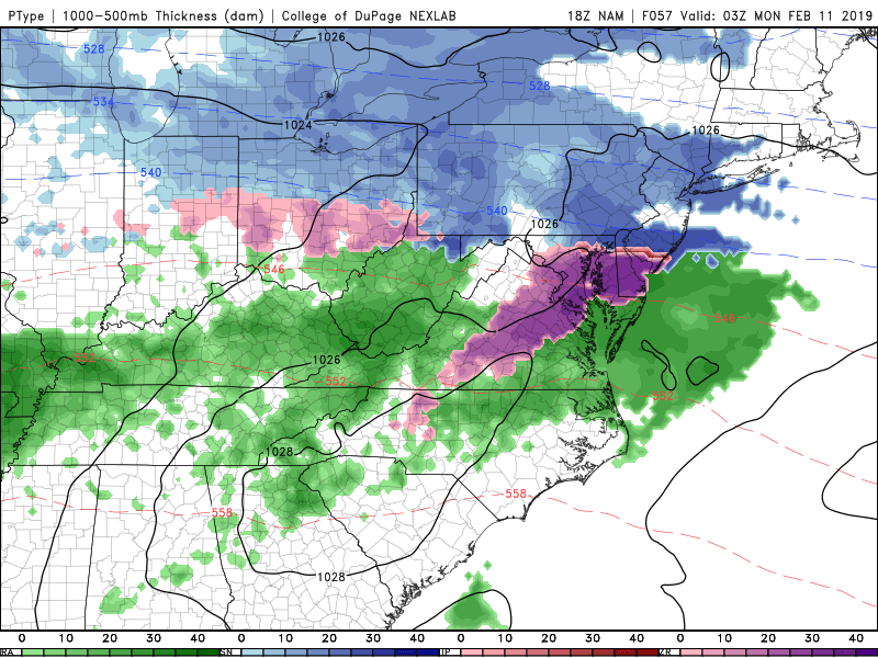
This evening’s NAM model showing the potential for some very light snow Sunday night/early Monday AM
Watching for a potential wintry mix on Tuesday
Our next area of interest will originate from a strong Pacific disturbance that will move into the Central US by Monday morning. The overall setup with this particular system will not be all that different than the previous systems that we have seen so far this winter, with an initial area of low pressure developing over the Plains by Monday afternoon. As this low pressure area matures over the Plains/Midwestern states on Monday night, a strong surface high pressure system will be gradually moving to the east over Southern Canada. Now nine times out of ten, a negatively tilted trough with a strengthening surface low cutting over the Midwest is not a setup in which we’d be looking for snow, but it is the location and timing of the aforementioned high pressure that makes this situation one to watch.
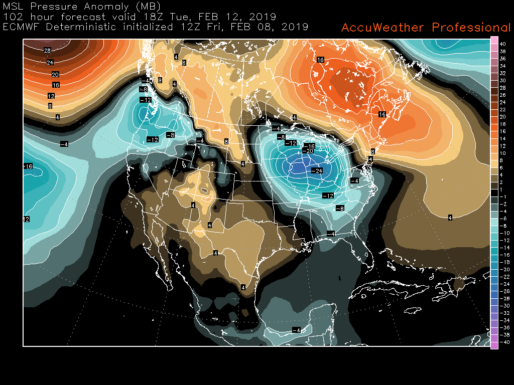
ECMWF model showing the surface setup on Tuesday AM. Blue areas represent lower pressures, with the warmer colors representing higher areas of pressure
As the surface low begins to move to the north over the Midwest early Tuesday morning, it’ll begin to encounter resistance from the high pressure located over southern Canada. At the same time, there will be large-scale divergence aloft over much of the Mid-Atlantic and Northeast (air spreading out above the surface) that will cause precipitation to break out. This initial “thump” of precipitation on Tuesday morning may initially come into the NYC area as a mix of snow & sleet, before changing over to sleet & rain during the afternoon hours.
While it is too early to talk about any specifics regarding exact timing and amounts, this system has the potential to bring some impactful weather across the area on Tuesday morning and we will need to monitor it cloesely over the next few days.
**Small changes in the exact location and strength of each system could mean the difference between a trace of snow and measurable snowfall for the NYC area. Make sure to check back for further updates!
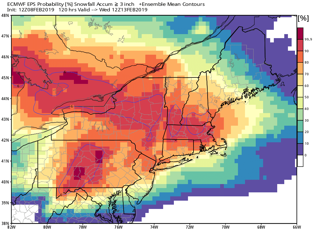
This afternoon’s European ensembles showing a high potential for 3″ or more of snow by Tuesday morning across the NYC area
Have a great weekend!
-Steve Copertino
Trackbacks & Pingbacks
1surrounded
Leave a Reply
Want to join the discussion?Feel free to contribute!