-2")
Snow and sleet to cause travel concerns Tuesday
Good evening!
Today has been a rather dull and cold day across much of our area as an upper level disturbance off to our west continues to produce widespread overcast. Some light to moderate areas of snow have been reported over southern portions of New Jersey today. The main story for our area continues to be a more impactful period of moderate to heavy snow that will gradually work its way into the Mid-Atlantic and Northeast by early Tuesday morning.
Conditions this evening across the New York City metro area will remain calm, but seasonably cold. Strong surface high pressure located over Southeastern Canada will help lock in very dry air over our area, keeping any potential precipitation at bay. With cold, but overcast conditions in place tonight, lows will only be able to drop a few degrees. Readings should dip into the lower to middle 20’s for much of the immediate NYC area, with upper 20’s possible along the coast. Areas of very light snow may try and develop later tonight across southern portions of New Jersey and Pennsylvania as the system off to our west begins to strengthen a bit. The aforementioned very dry conditions in our area will make it quite difficult for any meaningful precipitation to start before 5 am or so.
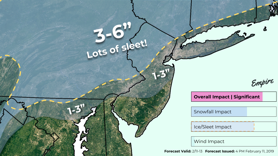
Our latest storm total snowfall accumulation map. A significant amount of sleet is expected to fall within the yellow hatched areas
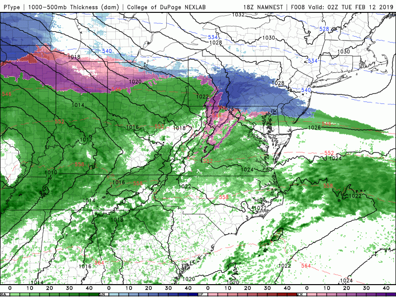
While the dry air may make it difficult for precipitation to initially develop over the NYC area, gradually increasing moisture from the maturing low to our west will result in the development of an area of light to moderate snow over portions of Eastern PA and into NNJ by 6-8am. Light to occasionally moderate snow will continue throughout the majority of the AM commute tomorrow, likely causing numerous travel delays and school closures across the northern portions of the metro area (see https://www.nymetroweather.com/school for more about potential closings)
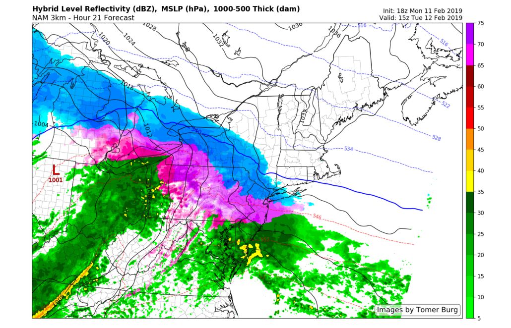
More substantial moisture rushes in from the southwest around noon tomorrow along with mid level temperatures that will be above the freezing mark. This setup could be a potentially hazardous one as surface temperatures will still be below freezing across much of the area. As a result, a mix of snow and sleet will likely break out from southwest to northeast tomorrow afternoon–possibly becoming heavy at times. Snow may be able to hang on a little longer over elevated portions of NW NJ and SNY, but the entire forecast area will likely flip over to an icy mix by 11am-1pm. There may be a prolonged period of sleet/freezing rain over the northern half of New Jersey and into Southern New York tomorrow afternoon, which may significantly impact the PM commute for much of the area.
As for snow totals, virtually all of the immediate NYC area will see a sloppy 1-3″ inches of snow before a mix of sleet and rain takes over by tomorrow afternoon. Elevated locations off to the north and west have a greater chance at staying all snow for a longer period of time, with 3-6″ of snow expected before the inevitable flip to sleet/rain.
This evening’s NAM model showing the evolution of tomorrow’s messy storm system
The overall impact from this system will ultimately come down to when the final push of above-freezing temperatures moves through. As of right now there’s a good amount of variance among the models with regards to timing, with some models keeping icy conditions through 8pm Tuesday. At this time it appears that this system will impact both the AM and PM commute tomorrow, with the potential for some hazardous travel conditions especially during the later half of the day.
A flip to moderate rain is likely during the evening hours of Tuesday from southwest to northeast across the entire area. Precipitation will quickly end during the early morning hours of Wednesday as a cold front works through the area. Mostly calm conditions are expected into the later half of the week, before we have to look west once again for our next storm system. We’ll have an update on Wednesday taking a look at what’s next on the horizon!
As always, get your butt to social media for the very latest, up to the second (we don’t sleep) updates from our team.
Have a great night!
-Steve Copertino
Thanks for sharing your thoughts about buy cialis.
Regards