-2")
Quiet end to the week, watching a few weak systems next week
Good evening!
Today has been a somewhat unsettled day, but a large improvement overall compared to yesterday when much of the area was battling snow and ice.
The area(s) of low pressure that affected the entire Northeast yesterday with snow, sleet, and freezing rain has finally pushed off to our north and east. This system left behind a decaying upper level low over the Great Lakes, which provided mostly cloudy skies and scattered snow/rain showers into the New York Metro area. Some of these snow showers were quite feisty, producing briefly reduced visibility and a very light snow accumulation in some spots.
Stout northwesterly flow aloft has developed in response to yesterday’s exiting system. This has provided cooler temps aloft, but southwesterly flow at the surface allowed for surface temperatures to rise into middle 30’s to lower 40’s across much of the New York City metro area this afternoon.
Relatively calm conditions will be in place this evening, however a few snow/rain showers cannot be ruled out later this evening and into the overnight hours-especially for locations off to the north and west as the upper level low to our north moves east. Additionally, a marginal pressure gradient has developed between the exiting storm system off to our north and a developing surface high to our south. This will create some occasionally gusty winds this evening, with some wind gusts getting into the 20-30 mph range.
Lows should fall back towards near-normal levels for the entire NYC metro area, with readings coming in at the middle to upper 20’s-with some lower 30’s along the coast.
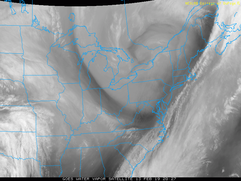
This evening’s latest regional high resolution water vapor loop showing the large upper level low moving off to the east
Relatively uneventful end to the workweek expected
Weak high pressure is expected to build into the region tomorrow morning (Thursday) as an area of mid level ridging moves into the East. Generally clear conditions are expected for much of the day tomorrow-with winds gradually subsiding. Highs will once again be right around normal (or slightly above) as southwesterly flow aloft increases. Temperatures will likely be in the upper 30’s to lower 40’s for the entire forecast area-making for a relatively pleasant day. Continued calm conditions are expected into the evening hours of Thursday as surface high pressure slides off the Mid-Atlantic coast. This should provide a more southerly component to the low level flow, which may aid in the development of mid level clouds during the evening hours. The mid level clouds and surface flow out of the south will keep temperatures a few degrees warmer than normal, with lows expected to be in the middle to upper 30’s across the area.
An area of low pressure will be passing through Southern Canada on Friday morning, which will put much of our area in the warm sector of this system as the warm front passes to the north. Mostly cloudy conditions are expected for the majority of the day, but there may be some breaks in the cloud cover before a cold front located to our west moves through. Southerly winds at the surface will usher in mild temperatures during the afternoon hours of Friday, with highs likely getting into the lower to middle 50’s–with some locations possibly hitting the lower 60’s if there is a prolonged break in the clouds.
A cold front will moves through the Northeast on Friday evening, likely producing a weak area of showers along the front. Moisture will be rather limited with this system, so mainly spotty & light showers are expected. Lows behind the front will fall back to seasonable levels, with lower to middle 30’s expected.
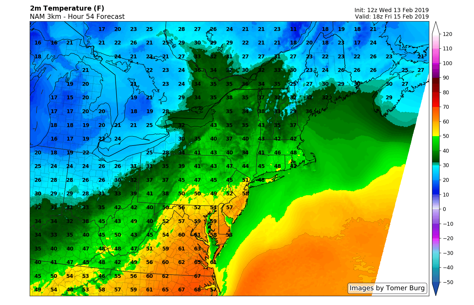
This evening’s 3km NAM showing high temperatures on Friday getting back into the lower to middle 50’s for portions of the area
A string of weak systems to watch through next week
The Winter of 2018-2019 continues to be a rather lackluster one as snow lovers in the New York Metro are left digging through the remains of this winter, feverishly grasping at anything that resembles a hint of an improved pattern.
Unfortunately, things do not look to improve all that much as we head through next week. A weak & fast-moving system will be moving through the Mid-Atlantic on Saturday, which has the potential to produce a swath of very light snow well to our south. This system will also be moving into a rather marginal airmass and is not likely to significantly impact our area with wintry weather. Yet another weak and sheared-out system will likely be moving through the Ohio Valley on Sunday, possibly producing a very light swath of snow through the Midwest-Ohio Valley. As it stands right now, most of the reliable model guidance keeps this system quite weak and suppressed, with only some light snow showers looking possible at this time for the area Sun/Sun night.
We may have to turn our attention to the West early next week as another large Pacific disturbance rolls in. While it is too early to say with any degree of certainty, this system may have the potential to impact our region during the Tues-Wed time frame.
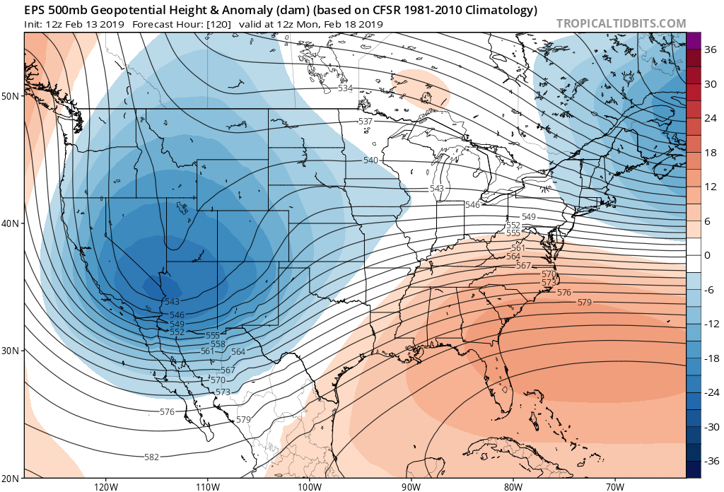
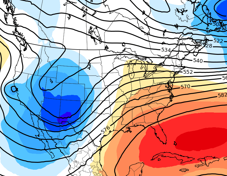
This afternoon’s European ensembles 500mb height anomalies showing a return to a trough in the West and a ridge in the East
We’ll have an update on this weekend and all of the systems involved over the next week on Friday!
-Steve Copertino
Trackbacks & Pingbacks
3steering
Leave a Reply
Want to join the discussion?Feel free to contribute!