-2")
Light snow likely Sunday night, watching another low on Wednesday
Good evening and happy Friday!
Today has been quite a pleasant way to end the workweek across the entire New York City metro area as highs rose into the middle 50’s to lower 60’s! These mild conditions will be short-lived as we turn our attention to two areas of low pressure that have the potential to bring some wintry weather to the area.
Rather calm and pleasant conditions transpired this afternoon as deep southwesterly flow ahead of an approaching cold front ushered in much-above normal temperatures into our area. This weak cold front is currently located over Eastern Pennsylvania, with only a few patchy showers accompanying it. Only a slight chance of a light shower or two will be possible this evening, mainly for locations off to the north and west of the immediate NYC area. Conditions behind the cold front will turn breezy and partly cloudy, which should be enough to hold off any significant radiational cooling through the overnight hours. As a result, lows will fall a few degrees, but still remain somewhat above normal. Expect readings to fall back into the lower to middle 30’s for the immediate NYC area, with upper 20’s likely off to the north and west.
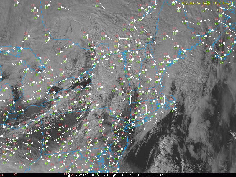
Visible satellite loop of a cold front approaching the NYC area with temperatures shooting into the 60’s ahead of the front
Relatively quiet weekend ahead, some light snow possible Sunday night
This weekend will start off quite calm and a good deal colder on Saturday morning as high pressure moves into the Northeast. Stout northwesterly flow will also be overspreading the area, injecting another rather cold and dry airmass. This will lead to mostly sunny skies for the entire forecast area, along with highs in the upper 30’s to lower 40’s. Conditions will remain relatively calm throughout the evening and overnight hours of Saturday as high pressure continues to build into the region. The fresh injection of dry/cold air, along with relatively calm winds will allow for much more efficient radiational cooling to take place overnight Saturday. Lows will likely drop well into the 20’s for the immediate NYC metro area, with teens possible for elevated locations off to the north and west of the city.
Sunday appears to be a day of transition as high pressure begins to move to the east of the area during the early morning hours. Conditions should start off generally cool and calm for the first half of the day, with highs likely getting into the middle 30’s to low 40’s. A weak area of low pressure will be quickly moving over the Ohio Valley and will rush into the picture by early Sunday evening-with overcast becoming likely for the entire area. An area of light snow will likely push through the NYC metro area during the evening/overnight hours of Sunday as the low pressure moves through the Appalachians. While the snow is expected to be primarily light in nature for the duration of this event, a weak secondary area of low pressure may try and develop off of the Mid Atlantic coast Sunday night.
This secondary area of low pressure would have the potential to cause some more robust precipitation to form to the north and west of the low, but the exact placement and timing of this secondary low is still to be determined. At this time, it appears that any snowfall from this system would be quite light, with a quick coating to around two inches generally expected from the immediate New York City metro to locations on north and west. Precipitation quickly ends from west to east early Monday morning, with gradually clearing skies expected by the late morning.
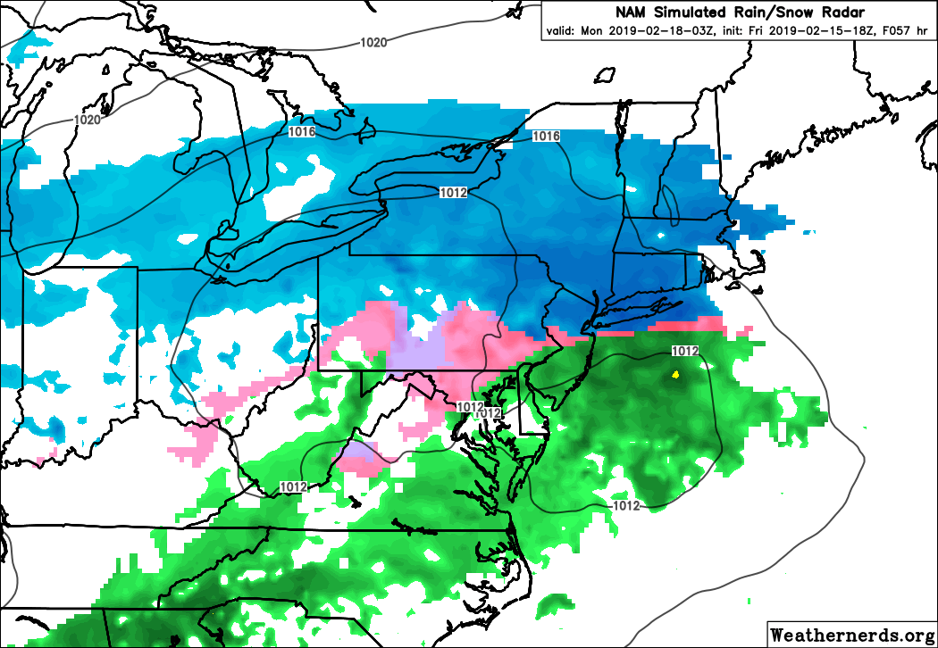
This evening’s NAM model showing an area of light snow breaking out across the NYC metro area late Sunday night and into the early morning hours of Monday
Watching a system during the middle of next week for a potential wintry mix
A relatively strong area of high pressure moves into the Plains and the Ohio Valley on Monday and Tuesday, sending another reinforcement of cold and dry conditions into the East. Highs on Monday and Tuesday will likely struggle to break out of the 30’s, with low temperatures falling into the lower 20’s for both days. At the same time, a large and deep trough originating from the Pacific will begin to dig into the Western US Tuesday night. As this trough continues to dig in over the Rockies, deep tropical moisture originating from the Western Caribbean will overspread much of the Southeast by early Wednesday morning. This will create a large area of moderate to heavy precipitation developing from the Southeastern states to the Mid Atlantic as high pressure continues to remain anchored in over the Northeast.
This setup is rather reminiscent of the previous storm system just a few days ago where we had a surface low cutting well off to our west with copious amounts of moisture running into an area of high pressure.
Like the past system, this precipitation forecast will be come down to the exact location of the high to our north and the track of the low pressure to our south. While we are still rather far out in time from this event, there does appear to be a moderate chance of some impactful wintry weather for the entire NYC metro area during the day on Wednesday. We’ll continue to monitor this system over the next few days, so make sure to check back for further updates!
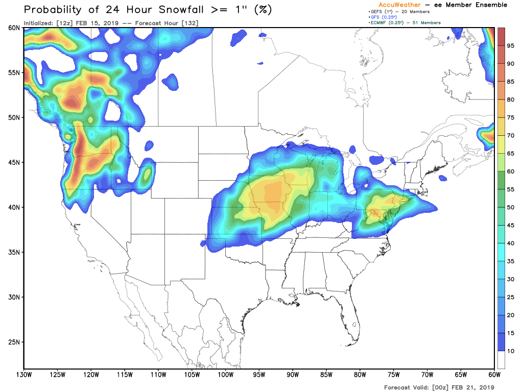
GEFS and EPS showing a high chance at seeing some measurable snowfall midweek next week
Have a great weekend!
Steve Copertino
Trackbacks & Pingbacks
2corporate
Leave a Reply
Want to join the discussion?Feel free to contribute!