-2")
System to our west brings heavy rains and strong winds, cold returns next week
Good evening and happy Friday!
Today has been a cool and calm day across much of the Mid-Atlantic, but this break will be short-lived as another system is poised to bring heavy rains and strong winds to our area over the next 72 hours! High pressure will usher in another round of cold next week, with mainly calm conditions expected throughout the week.
An area of high pressure has been gradually moving east over portions of Southern Canada throughout the day today, providing mostly clear and calm conditions. Mid level flow has been predominately from the northwest during the past 36 hours or so, leading to a relatively chilly airmass remaining in place over the Northeast. Highs today were able to get into the lower to middle 40’s across the New York City area, which is still a few degrees above normal for this time of year.
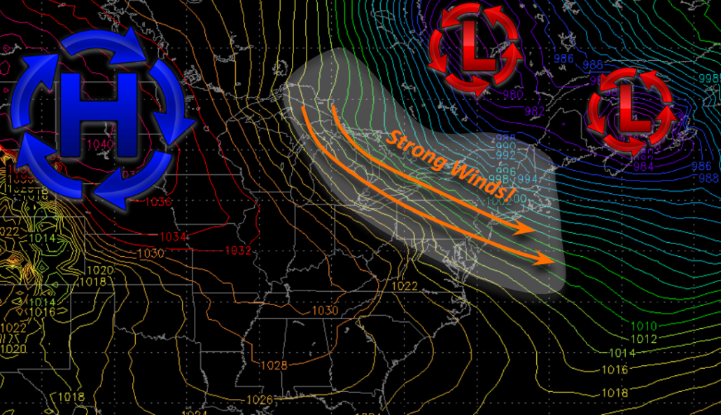
A deep and energetic trough has been making its way over portions of the Southwest CONUS during the past day or so, producing over 30″ of snow over portions of Arizona-with reports of snow in and around Los Angeles! This trough continues to move to the east this evening, dragging up copious amounts of warm/moist air from the Caribbean and Gulf of Mexico. All of this warm and moist air has been running into the aforementioned area of high pressure located over Canada, which has resulted in the development of widespread heavy rainfall over the Southeast.
Fortunately for us, the only impacts for our from this system during the next 24 hours will be increased cloudiness. High pressure will move overhead this evening and into the overnight hours, allowing for temperatures to drop back down into the upper 20’s to lower 30’s in and around the NYC metro, with lower to middle 20’s off to the north and west.
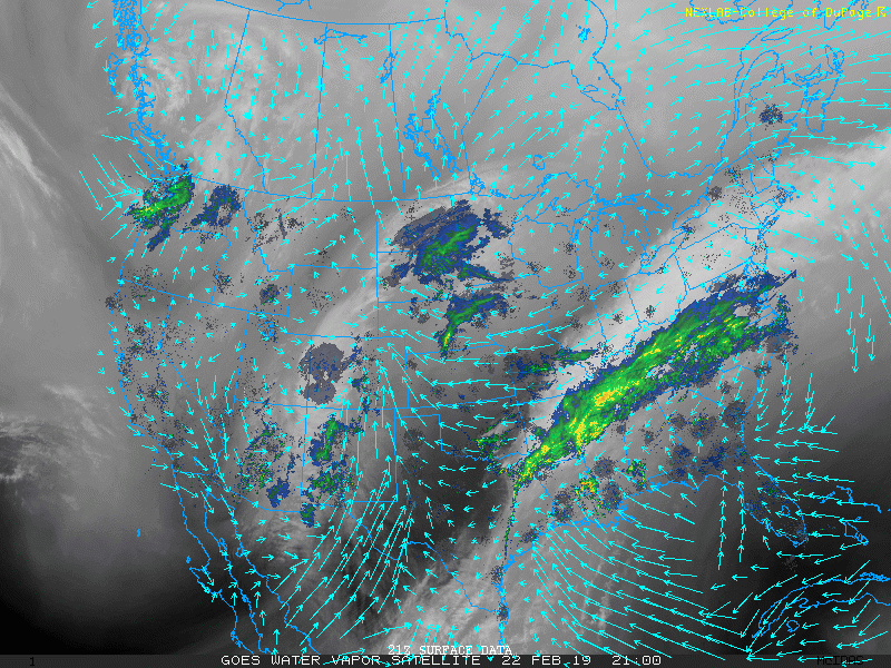
This evening’s latest water vapor imagery along with radar, showing moisture streaming into the developing system over the Southeast
Quiet Saturday gives way to an unsettled Sunday
High pressure will continue to move to the east during the early morning hours of Saturday. This will allow surface winds to become more southeasterly/southerly in nature by the afternoon hours, which will lead to increasingly cloudy conditions during the day. Despite the cloudy conditions, relatively dry air at the surface left over from the departing high off of New England should keep any shower activity at bay. A slightly warmer airmass will also be working into the region during the afternoon hours, which will allow highs tomorrow to get back into the middle 40’s once again. Deep southwesterly flow will then overspread the entire Northeast by the evening hours of Saturday. This will likely result in the development of light to moderate showers moving into the New York City area around 8-10pm. Despite the warmer airmass aloft, some pesky low level cold may try and hold on in some of the valleys off to the north and west of the city. Light freezing rain may be possible for these locations, but any freezing rain will likely transition to plain rain during the overnight hours. Lows tomorrow night will be well-above normal, with temperatures staying in the middle to upper 30’s across the region.
Even small amounts of freezing rain could make travel difficult tomorrow night, so please use caution when traveling in these areas
Sunday will easily be the most eventful day during the next week as the area of low pressure off to our west cuts into the Great Lakes. Moderate to occasionally heavy rain will overspread much of the area by 8am Sunday-with maybe a rumble or two of thunder possible. Steady rain will continue into the late morning & early afternoon hours before tapering off from west to east. Some residual showers will be possible as a cold front lags off to our west. With the cold front remaining off to our west during the afternoon hours, highs on Sunday will once again be above normal with upper 40’s to mid 50’s possible across the area. The cold front will then pass through during the evening/overnight hours-bringing in another shift back to colder temperatures. Lows will likely hover around the freezing mark on Sunday night, which will be right around seasonable levels.
As the area of low pressure off to our northeast intensifies, another high pressure system will be diving down from the Northern Plains. This will create a steep pressure gradient over the Northeast, which will introduce strong/gusty winds of up to 40-45 mph over the entire forecast area.
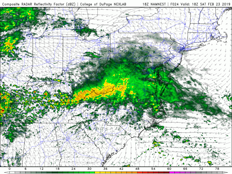
Thins evening’s high resolution NAM model showing the development of moderate to heavy rain Saturday night and into Sunday
Calm and below normal temperatures take hold next week
Strong winds will continue into Monday afternoon as the pressure gradient remains in place for the majority of the day. Conditions will be dramatically different from Sunday, with mainly clear skies and relatively cold temperatures in the 30’s expected. High pressure will continue to edge its way east during Monday evening, which should finally bring a relaxation to any winds. Northwesterly flow accompanied by high pressure will allow for continued clear and cold conditions to remain in place through the middle of next week.
Highs are expected to stay in the lower to middle 30’s for each day, with lows in the lower to middle 20’s likely. There may be a chance at some light snow showers towards the end of the week as a northern stream system moves in from Canada, but any chances at significant snowfall over the next week-and possibly into the first few days of March are virtually nonexistent.
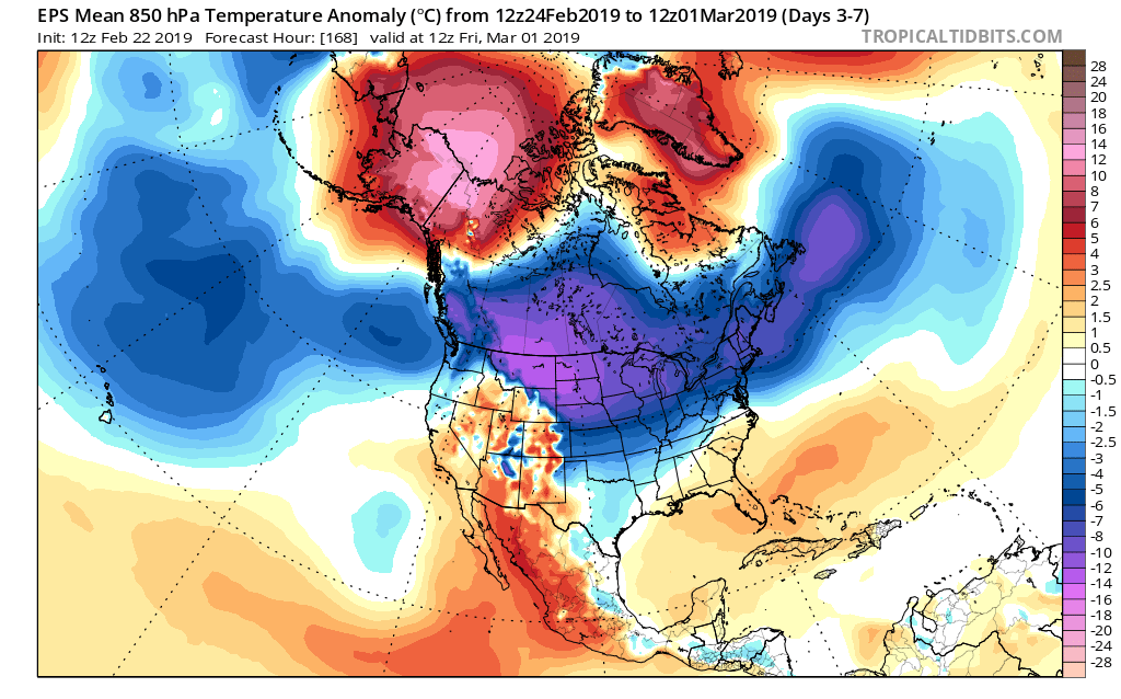
This afternoon’s European ensembles showing a colder pattern setting up over the northern half of the county during the next week
We’ll have an update on Monday! Have a great weekend!
Steve Copertino
Leave a Reply
Want to join the discussion?Feel free to contribute!