-2")

Winds gradually subsiding, light snow possible by Wednesday
Good evening!
Strong, gusty winds have continued throughout the majority of today as an area of low pressure off to our northeast continues to intensify. Thankfully, this looks to change as more cold and relatively calm conditions settle in before we have to worry about some light snow threats later this week.
Wind gusts today have been in the 45-55 mph range, with Bayville, NY (Long Island) coming in with the New York City metro areas strongest wind gust reading at 66 mph! These gusts have caused some hazardous travel conditions across the area, and sporadic power outages have been reported as well. Gusty conditions look to continue through the rest of this evening and into the overnight hours as an area of low pressure near Nova Scotia continues to intensify. In addition to the strong winds, colder air aloft will be working into the region, helping to bring in colder low temperatures for tonight. Lows will easily drop down into the lower to middle 20’s across the entire region tonight, with teens possible to the north and west of the immediate NYC area. Gusty winds in the 30-40 mph range will make it feel a good 5-10 degrees colder out tonight, so definitely remember to bundle up if you’re heading out!
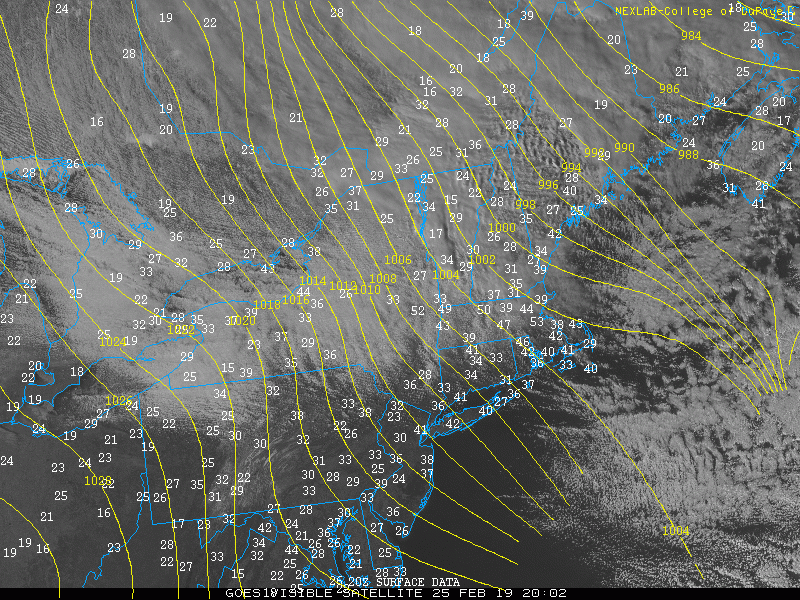
Visible satellite imagery this afternoon along with wind gusts (mph) across the Northeast this evening
Winds finally relax, light snow possible by Wednesday night
Tomorrow (Tuesday) will start off quite clear, with gusty winds likely hanging on through the morning commute. A strong area of high pressure located over the Northern Plains will continue to work its way east while the area of low pressure off to our northeast begins to accelerate out of the picture. This will begin to substantially weaken the pressure gradient over the area, with gusts dropping down into the 20-25 mph range by the afternoon hours. Conditions will remain rather cold and dry as deep northwesterly flow remains entrenched in over the Northeast. Highs will likely stay in the upper 20’s to middle 30’s across the New York City metro area, which will be slightly below normal for this time of year. Winds will continue to relax as we head into the evening and overnight hours Tuesday night as high pressure continues to work its way on into the Ohio Valley & Northeast. Mostly clear skies, cold air aloft, and subsiding winds will allow for decent radiational cooling to take place tomorrow night-with lows likely falling into the teens and lower 20’s across the entire metro area.
High pressure will continue to move into the Northeast by Wednesday morning, with mainly cold and partly cloudy skies expected. We’ll be closely watching a weak mid level disturbance by the early afternoon hours as it works its way into the Great Lakes region. This weak mid level system has the potential to produce an area of light snow by the afternoon hours of Wednesday–especially for locations to the north of NYC. While temperatures on Wednesday will struggle to break out of the upper 20’s, this system will be moving into a rather dry airmass and will have limited moisture to work with. This will ultimately limit the potential for a more widespread and impactful event, with the best lift and dynamics being located predominately north of the city. At this time it appears that a coating to an inch of snow will be possible from Wednesday afternoon and into the overnight hours for locations in the immediate NYC area, with potentially 1-3″ off to the north and west of the city.
It is important to note that this system has been trending a little more to the south over the past couple of model cycles, so we’ll have to keep an eye out for any further adjustments. Additionally, this system could impact the PM commute on Wednesday, so make sure to check back for future updates!
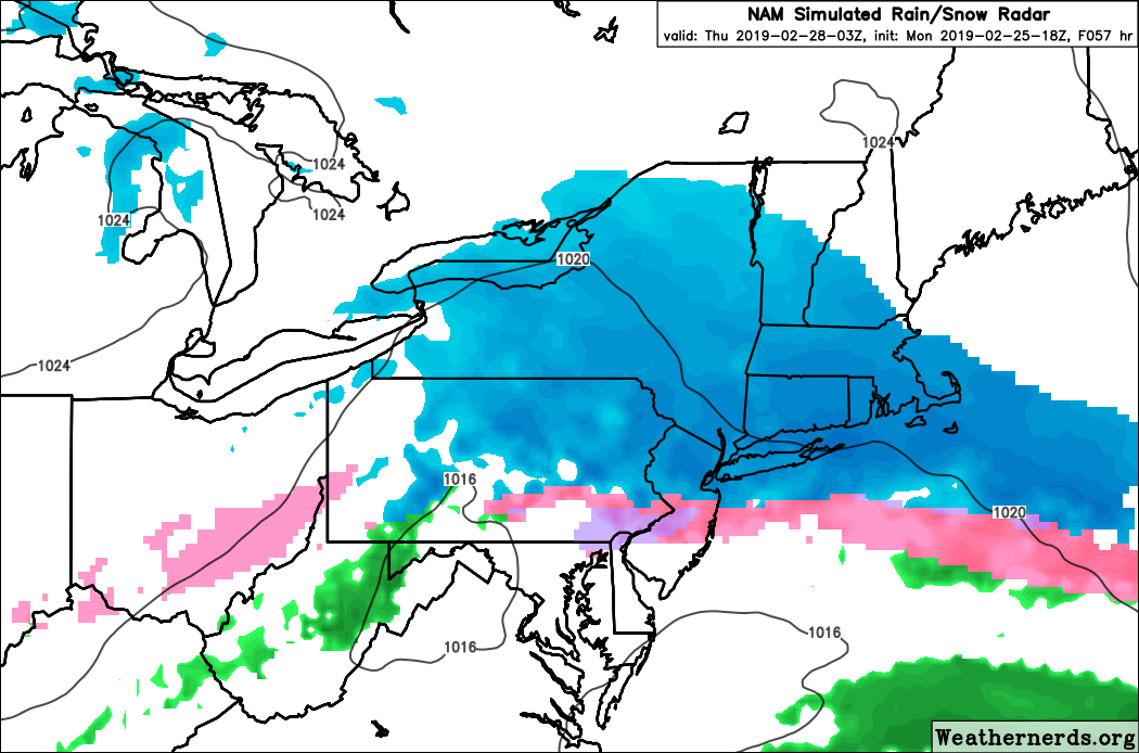
This evening’s NAM model showing an area of light snow moving through the area Wednesday afternoon
More light snow possible Thursday night, cold remains in place throughout the end of this week
Another weak mid level system will be quickly moving from west to east during the day on Thursday, likely reaching the Mid Atlantic coast by Thursday evening. At this time, it appears possible that another area of light snow may develop near/over the NYC metro area late Thursday morning and last into the early morning hours of Friday. Much like the Wednesday system, this system is rather weak and will be moving into a rather dry airmass. Any snow accumulations should be on the lighter side with minimal impacts expected at this time, before tapering off during the day on Friday.
One thing that is looking rather likely is the potential for below normal temperatures to close out the end of this week. A large and deep upper level low will be moving through Southern Canada, potentially reaching the Great Lakes by Saturday. This setup would introduce much-below normal temperatures into the Northeast later this weekend and possibly last into the beginning of next week. We may have to monitor the potential for another chance at some light snow on Sunday associated with the upper level low, but this will need to be revisited later in the week.
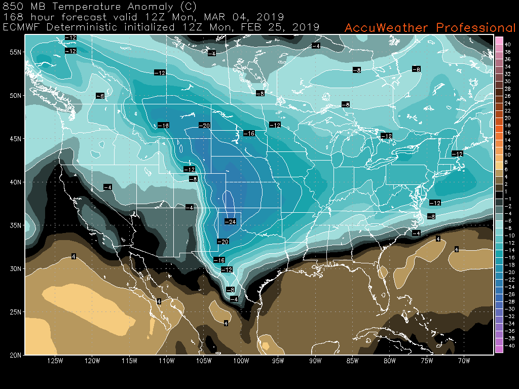
This afternoons ECMWF model showing the potential for another week of below normal temperatures across much of the country
We’ll have an update on Wednesday regarding the light snow event(s) as well as the upcoming cold!
Have a great night!
-Steve Copertino
Trackbacks & Pingbacks
3accomplished
Leave a Reply
Want to join the discussion?Feel free to contribute!