-2")
Snow likely in New England on Wednesday
Cold air has returned to the Northeast today, with still-blustery-but-not-end-of-times-blustery winds and very cold temperatures this morning. The good news? It’s clear and calm, and high pressure over the Eastern United States will continue to keep things that way through the remainder of the day. This will begin to substantially weaken the pressure gradient over the area (that was the cause of yesterdays strong winds), with gusts dropping down into the 20-25 mph range by the afternoon hours. Conditions will remain rather cold and dry as deep northwesterly flow remains entrenched in over the Northeast.
High temperatures today will likely stay in the upper 20’s to middle 30’s across the New York City metro area, slightly below normal for this time of year. Mostly clear skies, cold air aloft, and subsiding winds will allow for decent radiational cooling to take place, with lows likely falling into the teens and lower 20’s across the entire metro area later tonight.
High pressure will continue to move into the Northeast by Wednesday morning, with mainly cold and partly cloudy skies expected. We’ll be closely watching a weak mid level disturbance by the early afternoon hours as it works its way into the Great Lakes region. This weak mid level system has the potential to produce an area of light snow by the afternoon hours of Wednesday–especially for locations to the north of NYC.
While temperatures on Wednesday will struggle to break out of the upper 20’s, this system will be moving into a rather dry airmass and will have limited moisture to work with. This will ultimately limit the potential for a more widespread and impactful event, with the best lift and dynamics being located predominately north of the city. At this time it appears that a coating to an inch of snow will be possible from Wednesday afternoon and into the overnight hours for locations in the immediate NYC area, with potentially 1-3″ off to the north and west of the city.
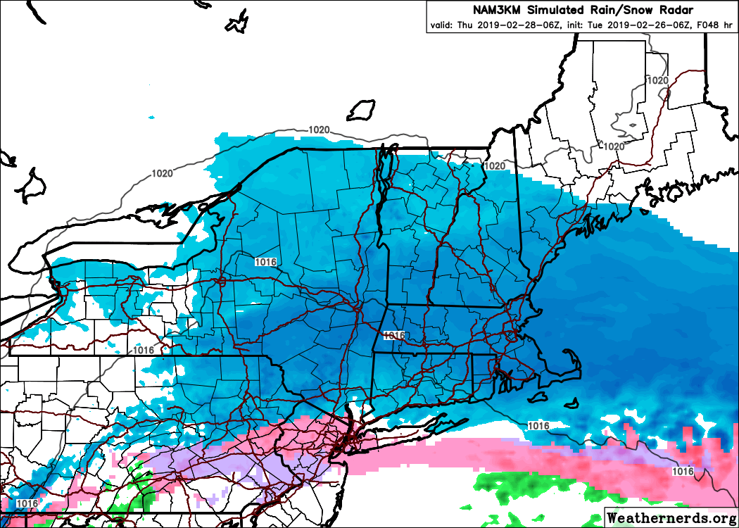
Further north, in New England, it appears likely that snow will be steadier, with the potential for a light to moderate event. Forecast model guidance suggests more impressive dynamics in these regions, particularly from New York State through Massachusetts and including parts of Connecticut. Light freezing rain and sleet are also possible in New York City as the system moves through.
System Highlights: Moderate snow in New England (3-6″) from NY State through Massachussetts. Light snow (1-3″) in the Lower Hudson Valley and Connecticut. Very light wintry accumulations possible in Northern NJ and NYC. Little to no impact south of NYC. Brunt of the system from Wednesday afternoon into overnight, system wraps up by Thursday mid morning.
More light snow possible Thursday night, cold remains in place throughout the end of this week
Another weak mid level system will be quickly moving from west to east during the day on Thursday, likely reaching the Mid Atlantic coast by Thursday evening. At this time, it appears possible that another area of light snow may develop near/over the NYC metro area late Thursday morning and last into the early morning hours of Friday. Much like the Wednesday system, this system is rather weak and will be moving into a rather dry airmass. Any snow accumulations should be on the lighter side with minimal impacts expected at this time, before tapering off during the day on Friday.
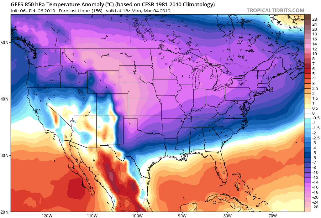
GFS model suggesting well below normal temperatures through the middle of March.
One thing that is looking rather likely is the potential for below normal temperatures to close out the end of this week. A large and deep upper level low will be moving through Southern Canada, potentially reaching the Great Lakes by Saturday. This setup would introduce much-below normal temperatures into the Northeast later this weekend and possibly last into the beginning of next week.
Thereafter, the chances for winter weather may increase as well. Medium and long range guidance has been suggesting the potential for a few disturbances – and with cold air in place, the potential would exist for later season snowfall. We’ll be closely monitoring over the next few days.
Leave a Reply
Want to join the discussion?Feel free to contribute!