-2")
Monitoring light snow chances into the weekend
Good evening!
The area of light snow that we have been monitoring for the past couple of days continues to move well to the north of the NYC area this evening. A couple more snow threats will approach the area over the next few days as below normal temperatures take over for the beginning of March.
Light to occasionally moderate snow continues to fall over portions of Central New York and New England this evening. This system has been running into a rather dry and stable airmass, which has really limited its overall impact on the area. A few bands of light snow managed to work their way into northern sections of the New York City area earlier this morning, producing a light coating of snow mainly on colder surfaces. Highs today were a few degrees below seasonable levels with upper 20’s to lower 30’s reported, which allowed for much of the snow that fell across northern sections of the area to melt.
Mainly cloudy conditions will continue throughout the rest of this evening before some light snow has a chance to redevelop later tonight. At this time it appears that portions of SE NY and SE CT have the best chance to see some additional accumulating snow through the very early morning hours of Thursday. Generally an inch or two of snow can be expected, which may create some hazardous travel conditions.
Further south, some very light snow and a mix of light freezing rain will be possible for the immediate NYC area later tonight and into the early morning hours of Thursday. While rather insignificant, this could potentially create some brief, but slick travel conditions for the AM commute.
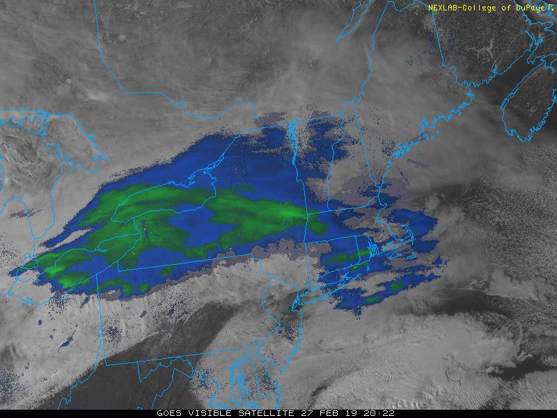
This evening’s latest visible satellite imagery and regional radar composite showing an area of light to moderate snow moving through CNY to Southern New England
Nuisance snow event possible Thursday night and into Friday morning
Gradually improving conditions will be moving into the Northeast tomorrow (Thursday) as any remaining light snow/mix heads off the New England coast for the morning commute. Dry air will quickly move in tomorrow behind this departing system, which will help to gradually clear skies throughout the first half of the day. Mostly sunny skies and a stale Arctic airmass will allow for highs tomorrow afternoon to run into the middle to upper 30’s, with lower 40’s possible for coastal locations. Another weak and fast-moving system will be approaching the Mid-Atlantic states by the late afternoon/evening hours tomorrow, with gradually increasing clouds expected by the PM commute. This system will be lacking severely in moisture, but there is a chance that some light snow could break out over portions of the Mid-Atlantic and into the NYC area very late Thursday night and into the very early morning hours of Friday. Impacts will likely be extremely limited, but this system could produce a quick coating of snow (especially to the south of the city) before the Friday AM commute.
Conditions may remain a bit unsettled as this system moves off the NJ coast later on Friday morning, with mostly cloudy skies expected. Highs on Friday should stay right around seasonable levels, with upper 30’s and lower 40’s expected across the area. Some light rain/snow showers may try to develop mainly to the south of the city on Friday evening, but these would likely be light in nature and would not have much overall impact on travel. Mostly cloudy and colder conditions take over again Friday night as another system approaches from the west. Lows drop back into the lower to middle 30’s, with upper 20’s expected off to the north and west of the city. Some areas of light rain/snow showers may continue into the early morning hours of Saturday, but again, impacts will be more “nuisance” in nature than anything.
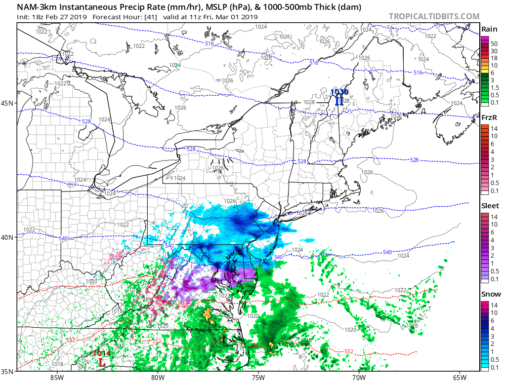
This evening’s NAM model showing the potential for another nuisance light snow event moving through southern portions of the NYC area during the early morning hours of Friday
Watching for another potential system Sunday night. Below normal temperatures take hold next week!
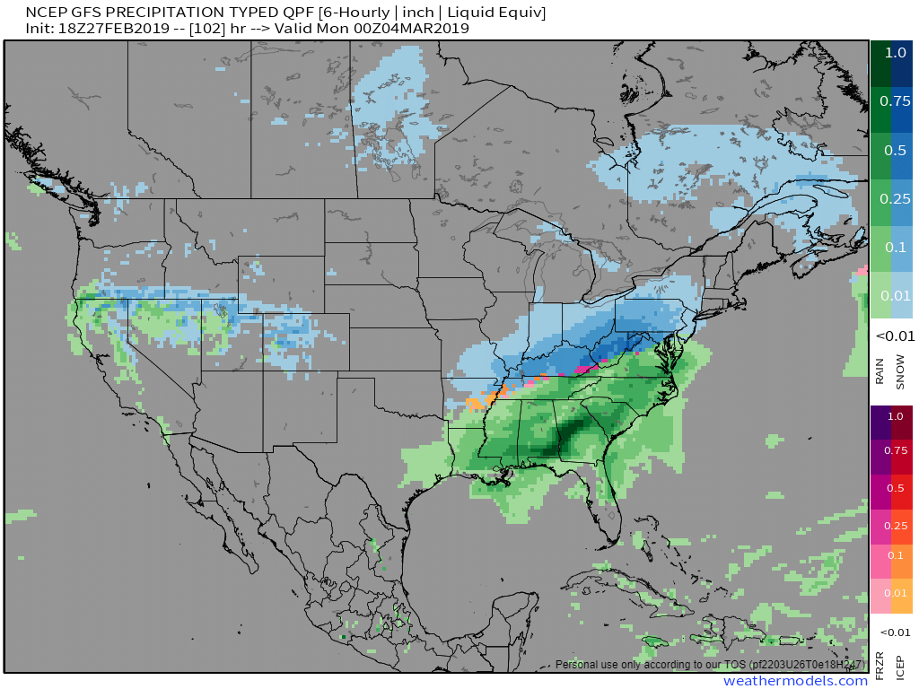
A large an anomalous upper level low will be situated over Southeastern Canada during the later half of this weekend. This upper level low will help to set up our next storm chance as another shortwave trough moves to its south by Sunday. Deep, cold air will be funneling into the Northern Plains and Midwestern states by this time, with warm/moist air moving up from the south. This will help to set up an impressive temperature gradient over the Eastern US as an area of low pressure develops along this thermal gradient.
Model guidance has been shifting back and forth with regards to the ultimate track of this surface low after it develops over the Southeast. Foreign guidance has been showing a track close/over our area, with the GFS (American model) showing a track to the south of the area Sunday night and into Monday. A track closer or just over the NYC area would introduce warm air from the south, which would result in more rain than snow. On the flip side, a track further to the south or further from the coast would provide a better chance at some snow for the region. The overall evolution of this system will likely shift around over the next few days and will need to be revisited, but this system could bring some potentially impactful weather conditions regardless of the track.
Much below normal temperatures look to pour into the Northeast behind this system, with highs potentially struggling to get above freezing through the middle of next week. A large an unusually deep trough will likely set up over the East during this time, which may cause the cold to last throughout the majority of next week!
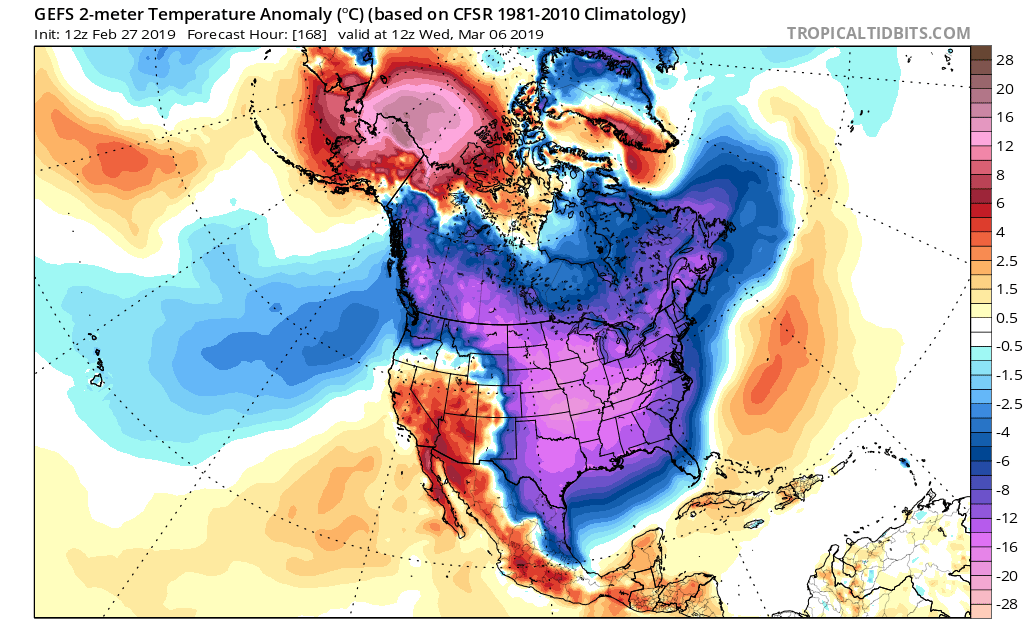
This afternoons GFS ensembles showing an impressive outbreak of below normal temperatures across the county next week
We’ll have an update on all of these potential systems as well as next week’s cold on Friday!
Have a great night!
-Steve Copertino
Trackbacks & Pingbacks
1archangel
Leave a Reply
Want to join the discussion?Feel free to contribute!