-2")
More snow likely tonight, complex storm for Sunday
Good evening!
Light snow moved across much of the New York City metro area early this morning with 1-3″ being reported over the majority of the area. Active times look to continue as we’re tracking not one, but two more systems that have the potential to deliver some impactful snow to the region!
Jumping right into things, snow quickly tapered off this morning as the small, but frisky shortwave trough associated with this system moved off the Jersey shore. Mostly cloudy skies and temperatures coming in around a few degrees below average were left in this systems wake-with highs only getting into the lower to middle 30’s for the entire NYC metro. Temperatures at or slightly above freezing in addition to the gradually increasing March sun angle allowed for much of the snow that fell this morning to gradually melt during the afternoon hours, leaving only remnants on colder surfaces.
Mostly cloudy skies and calm conditions are expected for this rest of this evening before we have to deal with our next system approaching from the southwest later tonight!
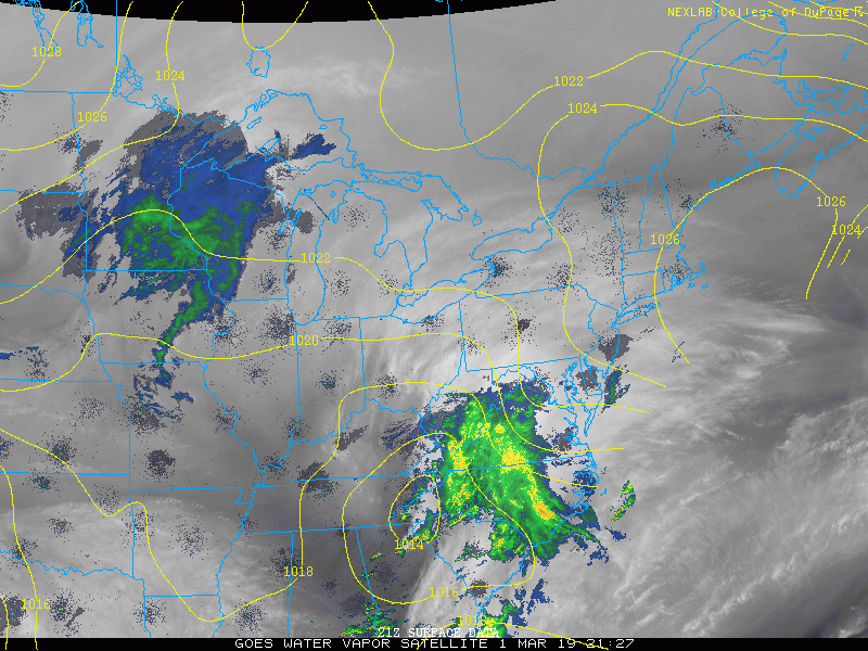
This evening’s latest water vapor and regional radar imagery showing our next storm developing over the Mid-Atlantic
Snow likely to impact the NYC area later tonight and into Saturday morning!
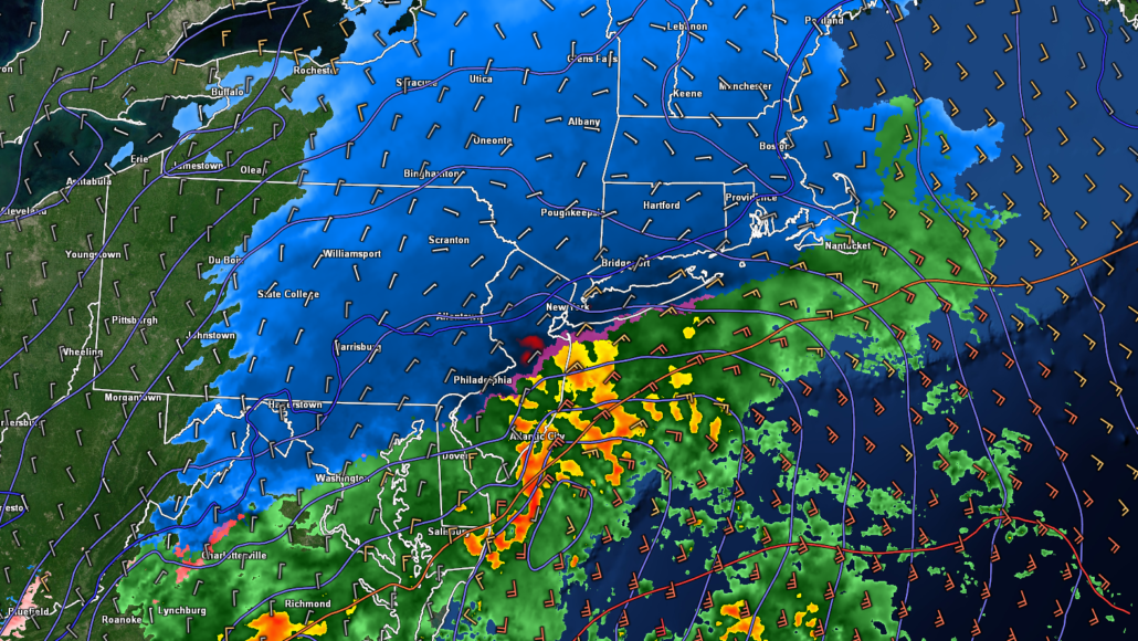
Another shortwave trough has been moving through the Mid-Atlantic states this afternoon/evening, which has led to the development of an area of rain/snow over portions of NC/VA/MD. This shortwave trough is expected to strengthen and take on a more negative tilt over the next couple of hours, leading to an area of low pressure forming off the Delmarva peninsula. Precipitation will likely break out over portions of SEPA and SNJ by 8-10 pm, with mainly rain expected during the onset for locations south and east of Philadelphia to NYC.
Things become much more interesting by around midnight for our area as the surface low pressure begins to intensify and more robust precipitation (likely in the form of snow) develops over SEPA, NNJ, and SECT. Moderate to potentially heavy snow should continue over this area from 12am to around 6am Saturday as the low begins to move quickly to the northeast. While this storm will not be a long-duration event, it does have the potential to put down some light to moderate snowfall before all is said and done.
Impacts: As of right now, much of the immediate NYC area looks quite likely to receive around 1-3″ of snow, with heavier amounts of 3-6″ expected off to the north and west of the city. Mainly a trace to an inch of snow is expected closer to the coast due to a more prominent mix of rain/snow. It is important to note that there are still some uncertainties regarding this system, especially for the locations highlighted below. This area will be the ultimate battleground for this system due to very marginal surface temperatures hovering around the freezing mark. Some locations could possibly receiving more or less snow than depicted depending on where the exact rain/snow line sets up!
(follow @nymetrowx on Twitter for the latest updates all night!)
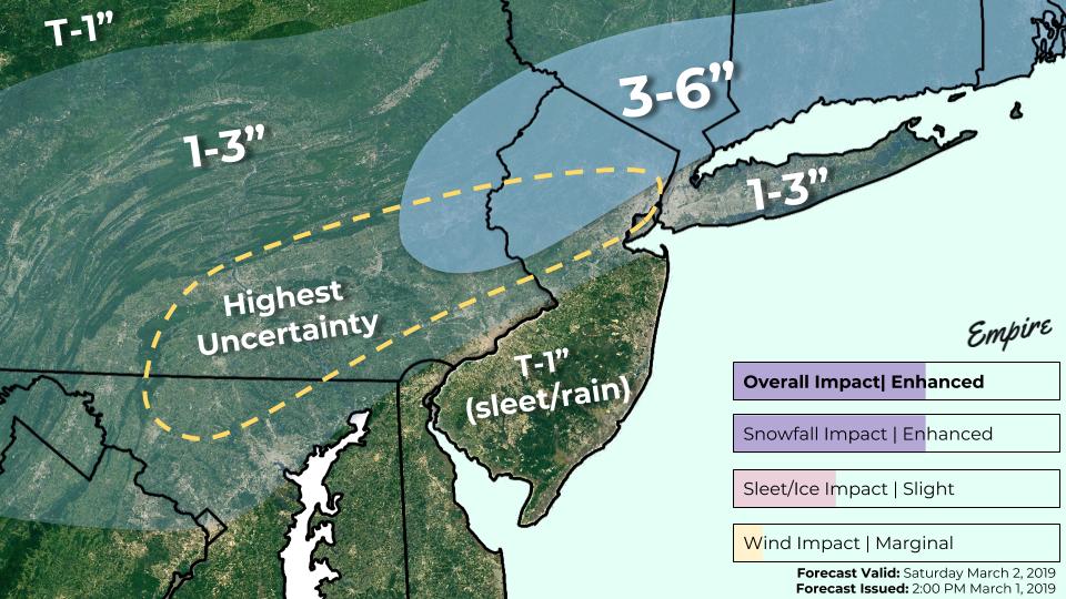
~Storm total snowfall forecast valid Friday night through Saturday morning ~
Complex situation unfolding for Sunday’s system
The final and potentially more impactful system looks to take shape on Sunday as yet another shortwave trough moves through the Ohio Valley and Mid-Atlantic states. A large area of precipitation will be developing over the Southern Plains by Sunday afternoon as deep tropical moisture streams in from the Gulf of Mexico and into the Southeastern states. Low pressure will develop over the Southeast by Sunday evening, which will cause an area of precipitation to begin to move into the Mid-Atlantic and Northeast. The majority of the reliable computer models over the past few days have been shifting a bit colder and further south with this system, which has increased the overall potential for significant snowfall across the area.
Low pressure looks to track off the Mid-Atlantic coast early Monday morning, with moderate to heavy snow impacting most of the NYC area. Locations closer to the coast/south and east of the immediate NYC area may struggle with a rain/snow mix once again as warmer air in the mid levels of the atmosphere moves in from the south.
Impacts: At this time it appears the most significant impacts will be felt just to the north and west of the NYC area, with mainly snow expected for those locations. The immediate NYC area will likely see light to moderate accumulating snow, but may have to contend with some mixing of sleet/rain at times. Further south, snow is expected on the front edge of this system followed by a flip to sleet and then plain rain.
Again, the overall evolution of this system is subject to change over the next 48 hours, and only small deviations in track/temperatures could shift these impacts either to the northwest or southeast! We’ll have an update on this system tomorrow, with more frequent updates on our twitter feed (@nymetrowx)
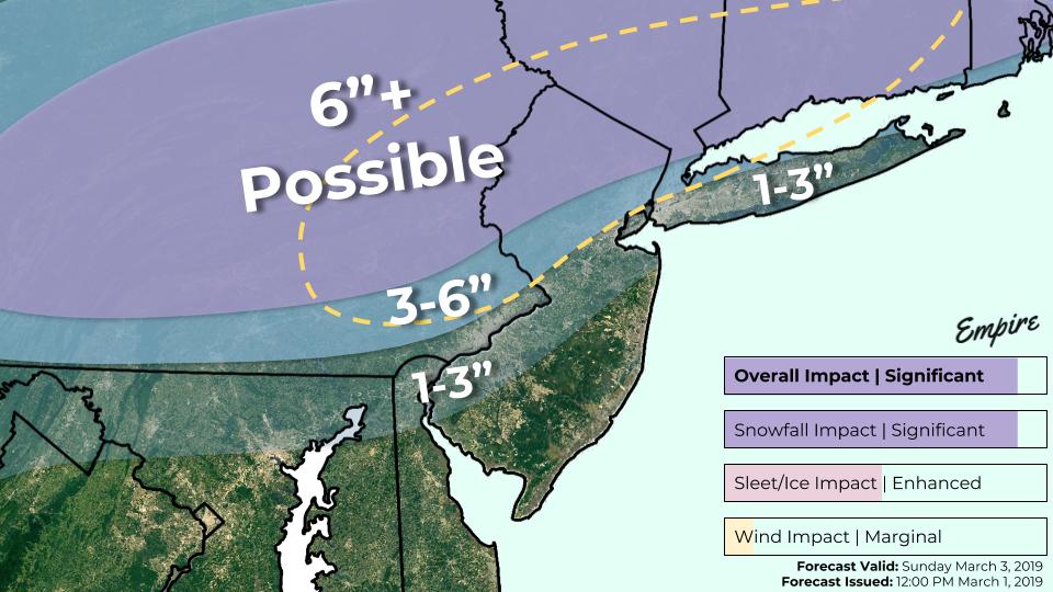
~First call storm total snowfall forecast for the system Sunday night and into Monday morning~
Have a great night!
-Steve Copertino
Leave a Reply
Want to join the discussion?Feel free to contribute!