-2")
Conditions turn tranquil and cool through next week!
Good evening and happy Friday!
The Northeast continues to remain relatively tranquil despite a historic blizzard, severe thunderstorms, and flooding rains across portions of the Central United States!
Today started off rather cloudy across the entire New York City metro area as deep southwesterly flow ushered in a more warm/moist airmass from the south. The deep southwesterly flow was also accompanied by pockets of some dry air in the mid levels of the atmosphere, which resulted in clouds clearing out much quicker than anticipated. This lead to high temperatures this afternoon absolutely running wild, with lower to middle 70’s over the immediate NYC area and over most of NNJ. Locations closer to the coast and over Long Island had to deal with cooler winds coming off of the Atlantic, which stifled the warming potential.
Areas of patchy clouds continue this evening, with some isolated showers and thunderstorms developing over portions of Pennsylvania as a result of weak instability building from daytime heating. Any showers and thunderstorms will likely stay off to the south and west, but a brief moderate to heavy rain shower could wander into portions of the NYC metro area early this evening. The shower threat then increases around 8-11pm for the region as a weak cold front begins to move in from the west. Some of these showers could be on the heavier side, with a rumble or two of thunder possible.
Conditions will gradually clear out after midnight for the immediate metro area as the front and associated moisture moves offshore. Breezy and cooler weather take over during the overnight hours, with lows dropping down into the lower to middle 40’s.
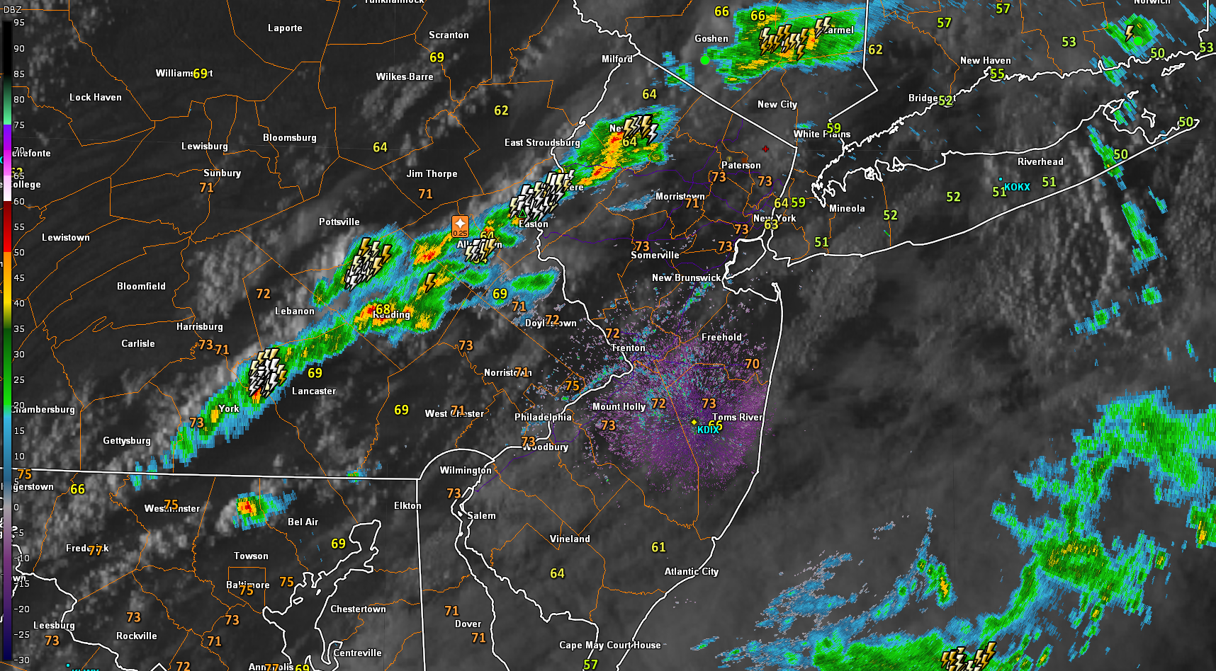
This evening’s high resolution radar and satellite data showing an area of showers and thunderstorm developing off to the south and west of the NYC area. These showers and thunderstorms will gradually make their way east, before pushing offshore overnight
Beautiful and calm weekend ahead!
Things look to start off quite clear tomorrow morning (Saturday) as strong westerly flow brings in a much drier and stable airmass. Colder air will remain bottled up in Canada through tomorrow, which should help highs get into the upper 40’s to lower 50’s across the area-which is slightly above normal for this time of year. Generally tranquil weather should remain in place throughout the evening and overnight hours as a weak area of high pressure moves over the Northeast. Clear skies, light winds, and a dry airmass will make for great radiational cooling conditions tomorrow night– with lows dropping back below normal. Expect temperatures to fall into the upper 20’s to lower 30’s for much of the area, with slightly colder readings for elevated locations off to the north and west.
Things look to turn a bit colder on Sunday as high pressure moves off the Mid-Atlantic coast and deep northwesterly flow from Canada finally takes over. While Sunday will be colder, this airmass will be extremely dry in nature, which should help to keep the entire area clear throughout the day. Calm, clear, and cool conditions will once again remain in place into the evening hours as radiational cooling takes over again. Lows Sunday night should be a bit colder, with temperatures expected to bottom-out in the middle to upper 20’s-with lower 30’s along the coast.
While temperatures will be a good deal colder than the past two days, mainly tranquil and clear conditions should make for an excellent weekend!
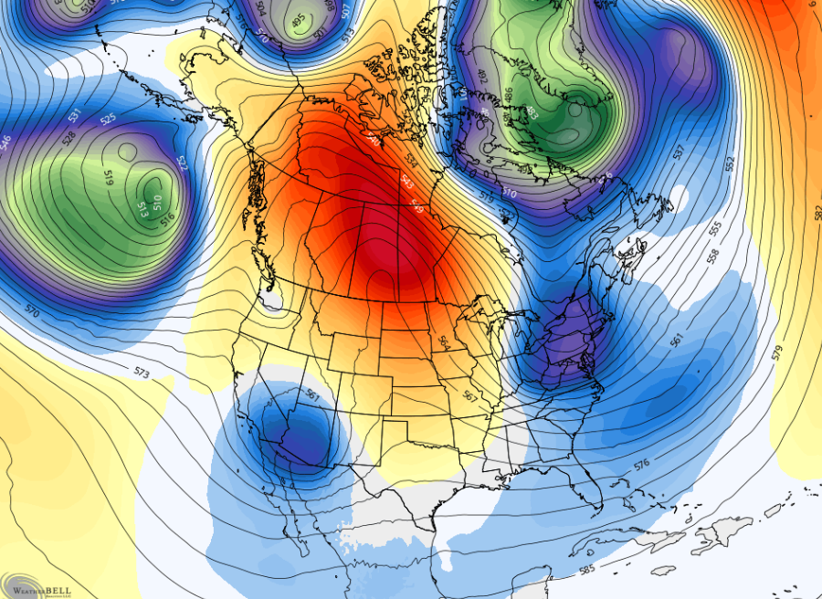
This evening’s NAM model showing a shift away from warm temperatures through this weekend. Generally cool and tranquil conditions can be expected through Sunday.
Not much change through the middle of next week
An area of upper level ridging looks to set up over portions of the Pacific Northwest and into Western Canada by Monday morning, which will push slightly cooler conditions into the Eastern half of the United States. Northwesterly flow will remain in place through at least the middle of next week, leading to mainly dry conditions and slightly below normal temperatures across our area. Highs will likely stay in the middle to upper 40’s each day, with some slight improvements possible later in the week.
Fortunately (or unfortunately), the pattern across the North Atlantic should keep any potential storm systems moving very quickly through the area, leaving little to no time for them to organize. This mainly dry and quiet pattern looks to continue into next weekend, with no major changes expected throughout the medium range!
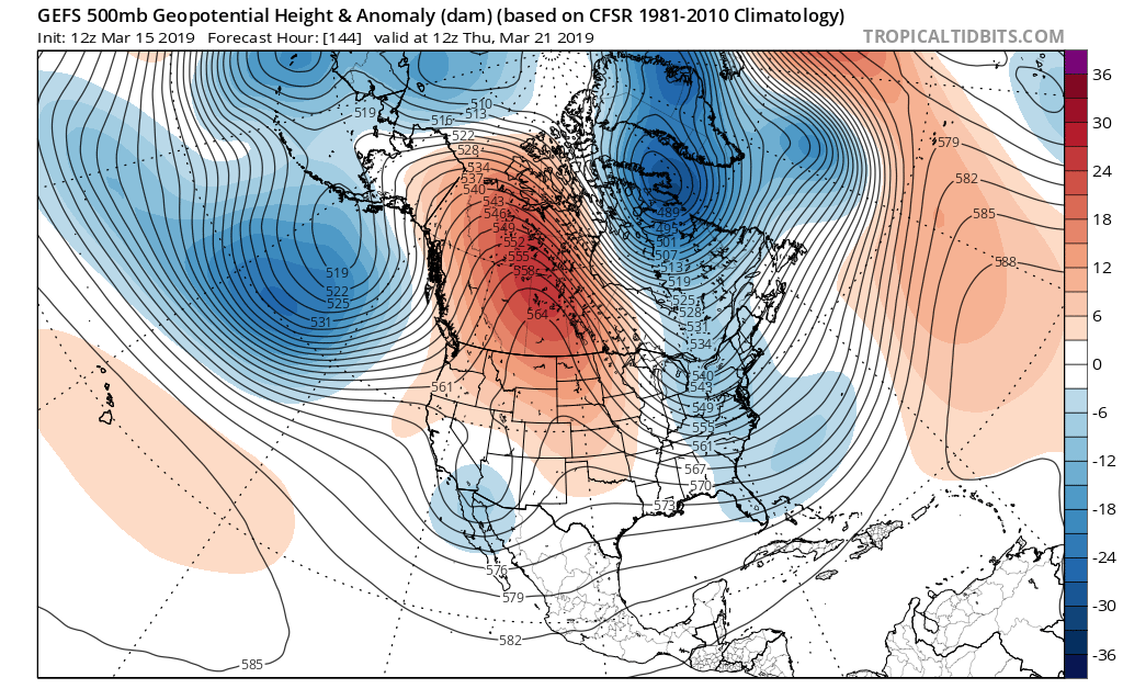
This afternoon’s GFS ensembles showing an area of ridging over the Pacific Northwest, with a trough extending from Canada and into the Eastern US.
Thanks for reading and have a great weekend!
-Steve Copertino
Leave a Reply
Want to join the discussion?Feel free to contribute!