-2")
Tranquil conditions turn wet and windy, cold shot next week?
Happy Vernal Equinox!
Unfortunately the quiet and tranquil conditions we have been enjoying for almost a week now will soon be coming to an end as an area of low pressure moves into the area late tonight!
A weak area of high pressure has continued to remain in control over much of the Mid-Atlantic and Northeast today. Westerly/southwesterly flow has remained firmly in place throughout the day, providing mainly clear skies over the area. Additionally, light southerly flow from the departing area of high pressure has allowed highs to climb into the upper 40’s to lower 50’s-which is right around normal for this time of year!
Clouds will begin to increase throughout the late evening and into the overnight hours tonight as an area of low pressure off the Southeast coast begins to moves north. The chances of meaningful precipitation from this system look to remain quite low throughout the overnight hours for the NYC area, but some stray showers may be possible over portions of Southern New Jersey. Mainly tranquil conditions, cloudy skies, and light winds from the east will allow temperatures to drop into the lower to middle 30’s across the entire area.
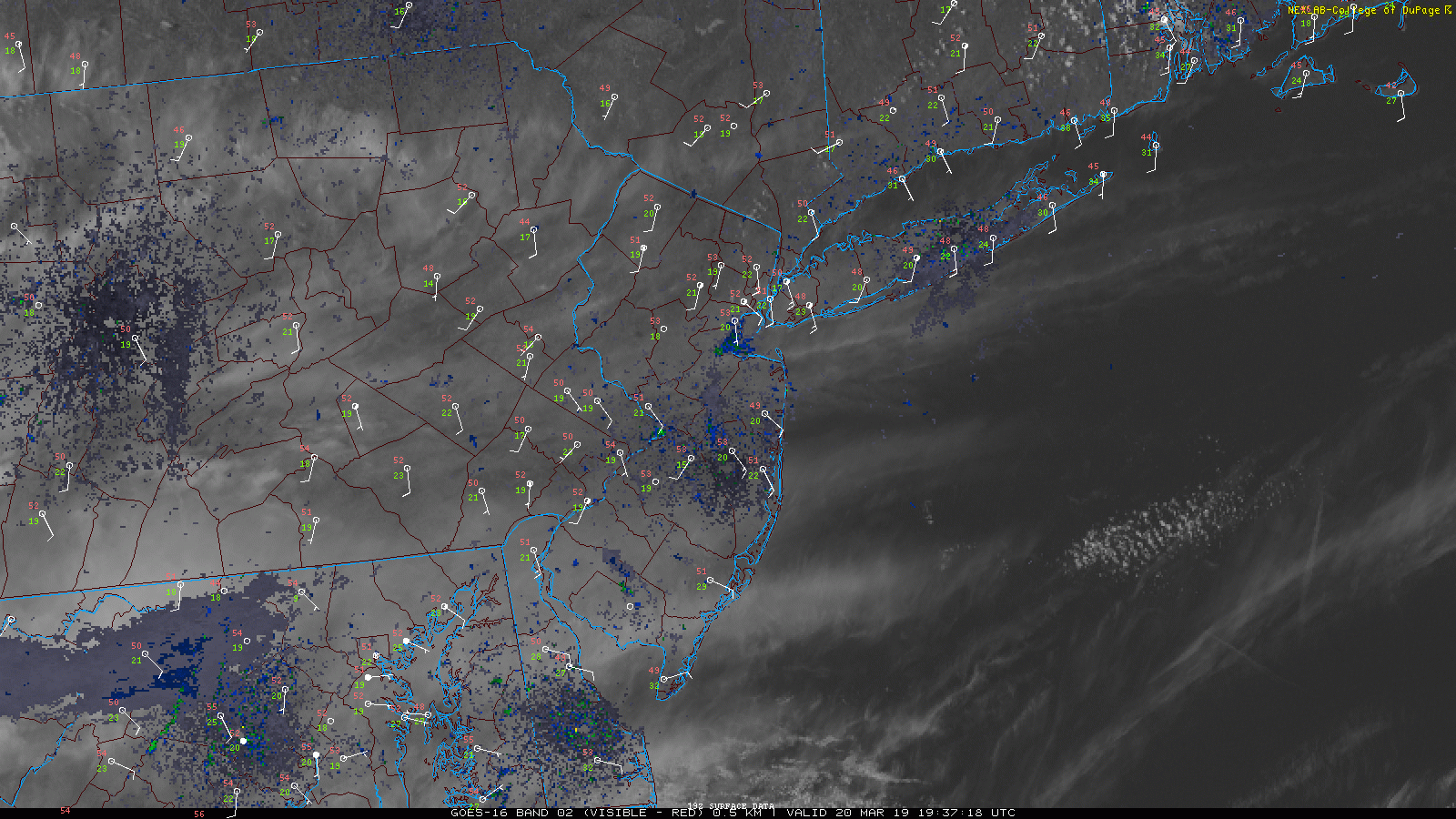
This evening’s latest high resolution visible satellite imagery along with surface observations showing a rather calm conditions across the NYC area
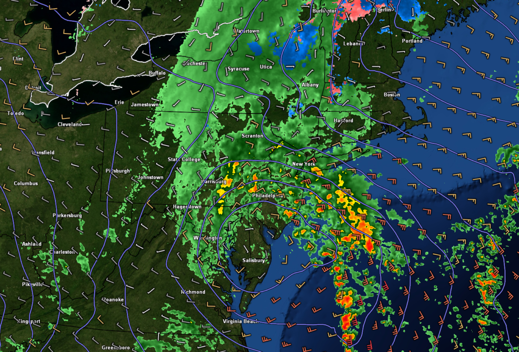
Low pressure moves in Thursday with periods of moderate to heavy rain
The area of low pressure moving north over portions of North Carolina and Virginia will begin to interact with an incoming shortwave trough over the Tennessee Valley Thursday morning. Showers will begin to gradually increase throughout the Thursday morning commute and into the early afternoon hours, becoming heavier in nature. This low will then begin to slowly strengthen as it fully phases with the shortwave trough, causing the rain shield to expand over our area. Cloudy and rainy conditions will only allow temperatures to rise into the middle to upper 40’s across the area, with pockets of colder temps off to the north and west.
Periods of moderate to potentially heavy rain will move through the NYC area from the late afternoon and into the evening hours as the low moves into eastern Maryland. Surface low pressure will continue to move closer into Pennsylvania/New Jersey during the overnight hours, causing precip to become more “showery” in nature. These showers will still be capable of brief periods of moderate to occasionally heavy rain, but the overall impact and flash flood threat for this event is quite low.
Some light showers will be possible into the Friday morning commute as the area of low pressure continues off to the northeast. This system will begin to rapidly deepen as another incoming shortwave trough phases with this system. Strong, dry northwesterly flow on the backside of this system will then quickly pile in over our area later in the day, causing winds to increase significantly. Wind gusts of around 20-35 mph will be possible for inland locations on Friday afternoon, with stronger gusts of up to 40+ mph possible over portions of Long Island. Highs on Friday will be surprisingly seasonable, with temps in the upper 40’s to lower 50’s. Conditions will once again turn more tranquil Friday night as winds begin to relax. Expect lows to drop down into the upper 20’s to lower 30’s across the area-which will be slightly below normal.
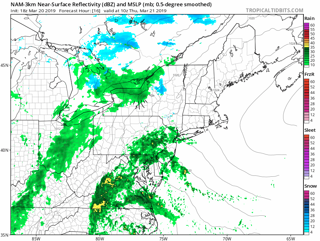
This afternoon’s NAM model showing the evolution of the storm system on Thursday
Calm and dry weekend ahead, watching for a potential cool shot next week
The large area of low pressure situated off to our northeast will continue to gradually move away from the area during the day on Saturday. Deep northwesterly flow will remain in place during much of the day. Highs will likely struggle to break out of the middle 40’s for much of the metro area, which will be a few degrees below normal. A weak area of high pressure looks to pass to the south of the area on Sunday, bringing in tranquil and mild conditions to much of the Northeast.
Things may try to turn colder with below normal temperatures during the beginning of next week as ridging over Western Canada begins to break down. This collapse of the ridge may send a quick shot of colder air from Canada into the East on Tuesday/Wednesday. Model guidance has also been hinting at an area of low pressure possibly moving in around our area during this time, but there has been very little run-to-run consistency on the track and overall evolution of this system.
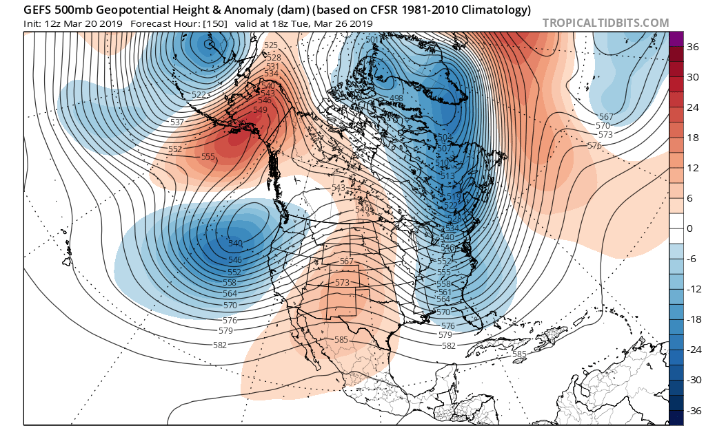
Today’s GFS ensembles showing an interesting upper level setup favorable for a quick-hitting cold shot by early next week.
We’ll have an update for you on Friday!
Have a great night!
-Steven Copertino
Trackbacks & Pingbacks
2entirely
Leave a Reply
Want to join the discussion?Feel free to contribute!