-2")
Gradually improving temperatures into this weekend
Good evening!
Unseasonably cool temperatures and calm conditions have continued to remain firmly in place over much of the Northeast. While temperatures look to improve into the weekend, we may have to contend with an approaching cold front later in the forecast period.
Today has been an extremely calm day across the entire Northeast as the area of high pressure that has been controlling our sensible weather slowly moves offshore. Some areas of thin cirrus clouds have been present over the immediate New York Metro area this afternoon, with mostly sunny skies elsewhere. Cool winds coming off of the Atlantic (onshore flow) has also been increasing throughout the day. This has had a appreciable impact on our highs across the region today. Highs were once again below normal for this time of year, with lower to middle 40’s over the immediate NYC area and middle to upper 40’s (with some spotty 50’s) off to the north and west.
Much of the same looks to continue into the evening and overnight hours as high pressure continues to move off the New England coast. Light winds, relatively clear skies, and dry mid levels will allow for decent radiational cooling to set up tonight. Expect lows to once again drop down into the upper 20’s to lower 30’s for the immediate NYC metro, with middle to upper 20’s likely for elevated locations off to the north and west.
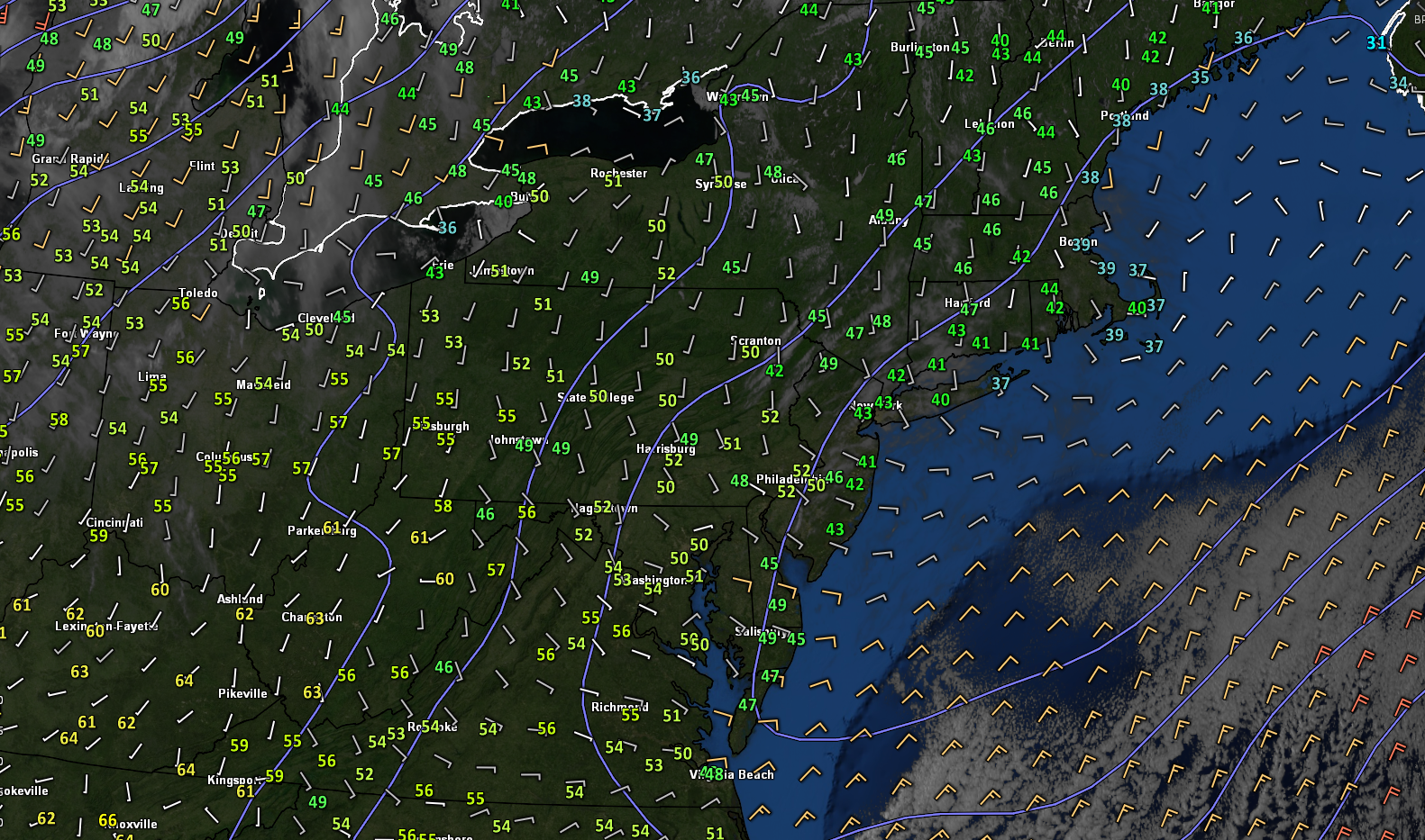
Snapshot of this evening’s latest high resolution satellite, regional radar mosaic, and surface winds/temperatures
Temperatures improve through Friday but clouds and some showers possible
Tomorrow (Thursday) will start off quite cool, but rather clear as dry air aloft remains in place over the region. Southwesterly flow will also be on the rise by tomorrow afternoon, providing a healthy flow of warmer mid level temperatures into the area. The combination of sunny skies and warmer air aloft will allow for highs to reach into the middle to upper 50’s for the immediate NYC area, with some 60’s possible over portions of NE NJ. Continued onshore flow from the cool Atlantic will likely stifle temperatures closer to the coast, with lower 50’s likely. Clouds will then likely begin to increase late tomorrow afternoon and into the evening hours as an approaching frontal boundary edges into the area. Thankfully this front will be quite weak and moisture starved in nature, likely resulting in only a few showers mainly to the north and west of the city. Lows on Thursday night will be slightly improved, with mostly cloudy skies and the threat for a shower keeping a floor on just how low temps can fall. Expect lows mainly in the lower to middle 40’s for the immediate NYC area, with slightly colder readings to the north and west.
Southwesterly flow will continue to increase into Friday as the aforementioned frontal boundary remains off to our north. Mid level moisture will also be on the rise during the morning and afternoon hours of Friday, which may allow for a couple of showers to pass through the area. Despite the mostly cloudy skies and threat for some light showers, highs will likely improve once again. Expect temps to get into the upper 50’s to lower 60’s across the immediate NYC area with portions of NE NJ likely hitting the middle 60’s! As always is the case in early Spring, temperatures will be cooler over coastal sections of NJ and Long Island with 50’s expected. An isolated shower threat may linger into the evening and overnight hours of Friday as mid level moisture remains in place. However, this threat will be quite low given that there really isn’t any mid level system present to focus shower activity over the region. Lows on Friday will remain cool, but improved once again with temps in the middle to upper 40’s for the majority of the area.
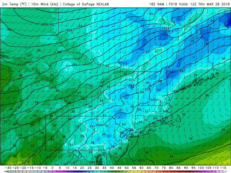
This evening’s NAM model showing temperatures gradually improving through Friday
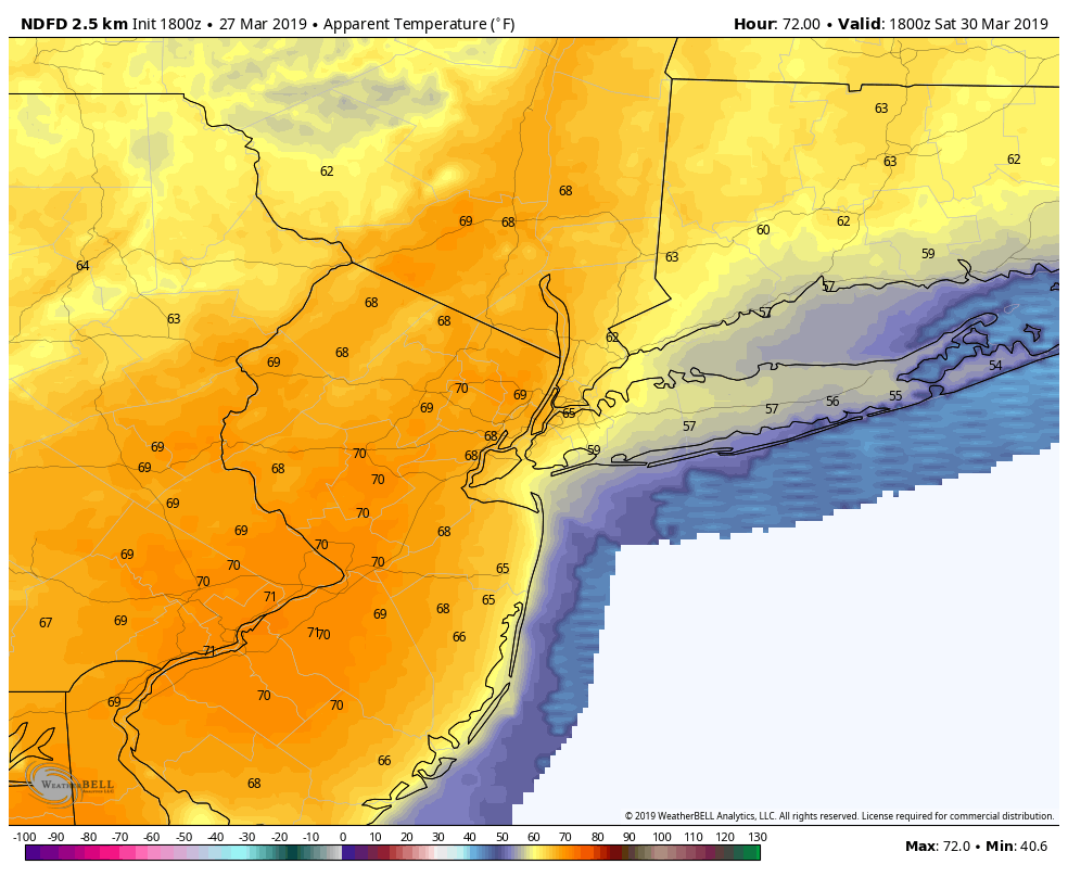
Roller coaster of temps possible this weekend!
Very deep southwesterly flow will continue to increase over much of the Mid-Atlantic and Northeastern states during the day on Saturday. Models have been flipping back and forth with regards to the amount of available moisture and clouds for our area, which will have a large impact on actual highs. At this time, it appears likely that highs on Saturday will rise at least into the middle to upper 60’s across the vast majority of the NYC area. Some model guidance has been hinting at temperatures rising into the lower to middle 70’s, but this scenario is considered an outlier at this time given the uncertainty. Regardless, mild and mostly cloudy conditions are likely. A cold front and its associated light rain will gradually move through the Northeast on Sunday, bringing an end to the mild temperatures for our area. Highs will likely drop back into the middle to upper 50’s once again, but both Saturday and Sunday will need to be revisited on Friday for further tweaks.
The cold front looks to push offshore by the early morning hours of Monday morning, ushering in yet another cool airmass into the Northeast. Temperatures will likely remain below normal with calm conditions through the middle of next week as an area of high pressure builds into the Northeast keeping things dry.
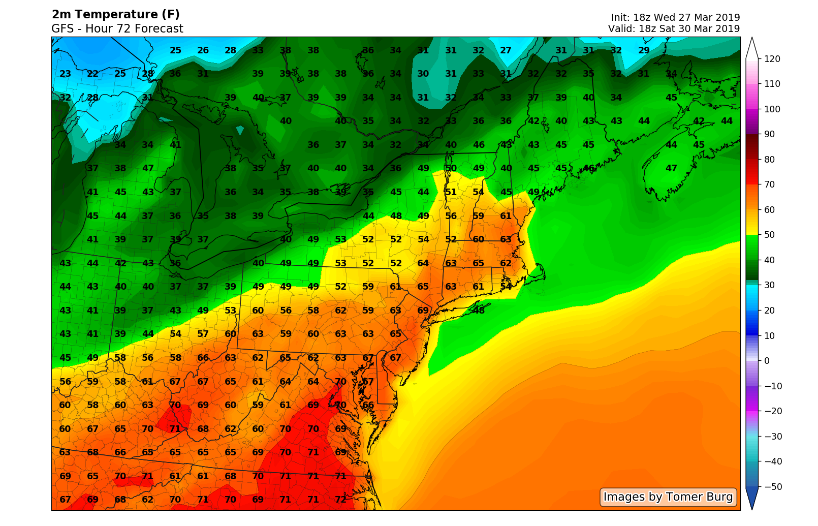
This evening’s GFS model showing rather mild temperatures possible for Saturday afternoon!
Thanks for reading! We’ll have an update on Friday!
-Steve Coprtino
Trackbacks & Pingbacks
2browsing
Leave a Reply
Want to join the discussion?Feel free to contribute!