-2")

Beautiful warm weather overall this weekend, scattered storms possible late Sunday and Monday
Happy Saturday! High pressure will continue to provide partly to mostly sunny skies today. Temperatures will be a little cooler than on Friday. But it will still be warm this afternoon with highs reaching the lower to middle 70s throughout much of the New Jersey and New York City area. Winds will be mostly light out the north and west during the day. This will allow for sea-breezes to develop this afternoon, which may keep Long Island and shore areas from rising out of the upper 60s. But overall it will be a beautiful day for the entire region.
Then high pressure begins sliding offshore with light winds becoming more south-southeast tonight. This will allow for moisture to build and clouds to increase, ahead of a warm front to approaching the region. We can’t rule a few isolated showers late tonight or early Sunday morning with some weak lift from warm-air advection. But subsidence from an upper-level ridge also building over the region will most likely prevent much rainfall. Overnight low temperatures will be in the mid-upper 50s or lower 60s.
During the midday hours on Sunday, the warm front will be lifting northward through the New Jersey and NYC area and stronger upper-level ridging will build over the region. This will support clouds to mix with more sunshine and more southerly winds, which will help temperatures rise into the mid-upper 70s and the lower 80s in some spots. Southerly winds off the ocean will keep high temperatures in the upper 60s to lower 70s over Long Island and Connecticut. But overall it will be another beautiful day.
Scattered storms possible late Sunday and Monday…
The upper-level ridge will begin to breakdown late in the day on Sunday, as an upper-level trough begins move out the Great Lakes. There will also be a strengthening 850mb level southwesterly jet ahead of this trough. Thus chances for scattered showers and thunderstorms will increase over the region late Sunday afternoon and evening. Instability and shear may increase enough to support a few isolated strong to severe thunderstorms with heavy rainfall, gusty winds and frequent lightning. But much of this activity will likely be over Interior areas of NY/PA/NJ, while marine influence from the sea-breezes keep NYC and coastal areas more stable with storms weakening as they approach.
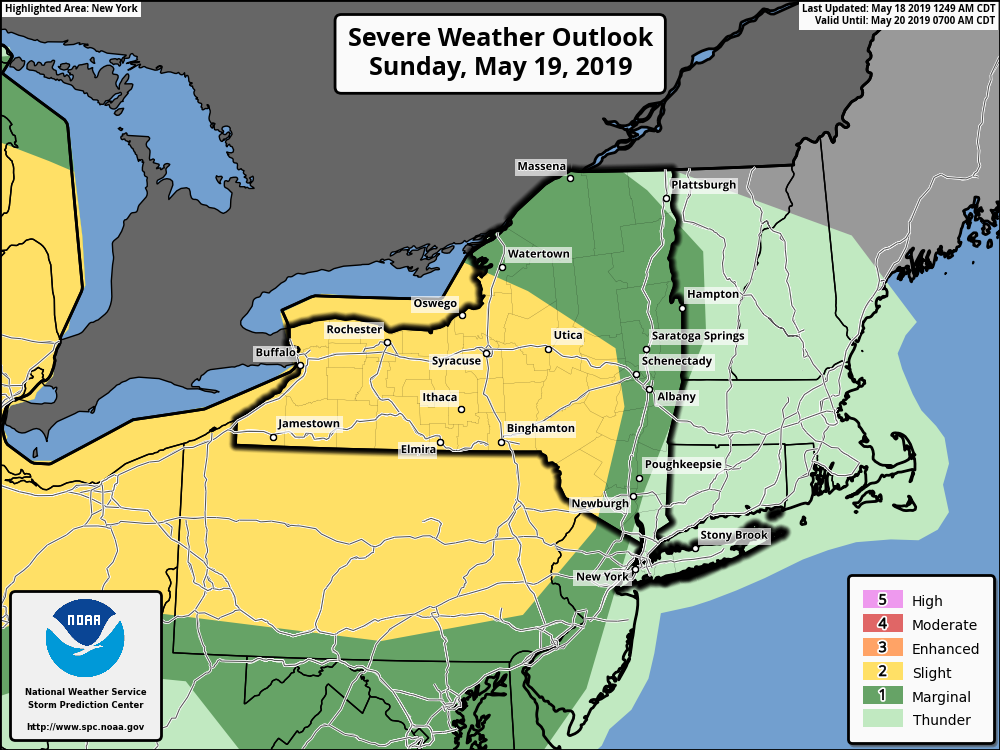
The Storm Prediction has placed Interior parts of New York, Pennsylvania and New Jersey under a Slight/Marginal Risk of severe thunderstorms on Sunday. The main threat from storms is for damaging wind gusts.
Monday will be partly sunny, warmer and even a little humid with a deeper southwest flow ahead of the cold front approaching the region. High temperatures are likely to reach the lower to middle 80s over much of New Jersey and NYC area on Monday. Sea-breezes in the afternoon again will keep Long Island and south-facing shores a little cooler–in the 70s. But it will likely be the warmest day of the season so far for the entire region.
More scattered showers and thunderstorms are possible, as the cold front moves through during the afternoon and evening hours on Monday. However most of the shortwave and jet streak energy with the upper-level trough will likely pass well north of the region, which means less dynamics for more widespread convection and severe weather.
More seasonable warmth mid-week, next shower threat late week…
Then temperatures will return closer to seasonable levels for middle of the next week. High pressure will support dry conditions on Tuesday and Wednesday, before another disturbance arrives with more showers and thunderstorms possibly by Thursday and Friday. Overall, an active pattern with more seasonable warmth is expected for the region, while a heat wave builds with a stronger ridge over the Southeast US during the week.
More updates to come early next week!
-Miguel Pierre
Doees your websie havfe a ckntact page? I’m having problemss locationg it but, I’d ike
too send youu an e-mail. I’ve got ome creaative idedas
forr your blog you might bbe interested inn hearing. Eituer way,
gfeat sitge annd I look forward to seeing it expandd ovver time.