-2")
Exceptionally hot & humid conditions likely throughout the week
Good evening!
The substantial heatwave that we have been warning about looks to finally crank up this week. Conditions will start off rather reasonable, but the heat and humidity will be in full-swing around mid-week. The entire NYC metro is likely to see several days above 90 degrees, with temps possibly roaring above 100 to close out the week!
Today started off much like the past couple of days have. Clear skies, warm temps, and light winds this morning allowed temps to quickly rise during the early afternoon hours. Highs were able to reach into the middle to upper 80’s across the entire metro area with a few 90-degree reports over NE NJ. Despite the very warm temps across the area, northwesterly flow aloft has kept dewpoints in check (for now). Latest readings around the area were in the upper 50’s to lower 60’s, which is actually pretty tame considering what is to come. Generally warm and dry conditions are expected to last into the evening and overnight hours. Thankfully, lows will remain right around seasonable levels, with readings in the middle 60’s across the area.
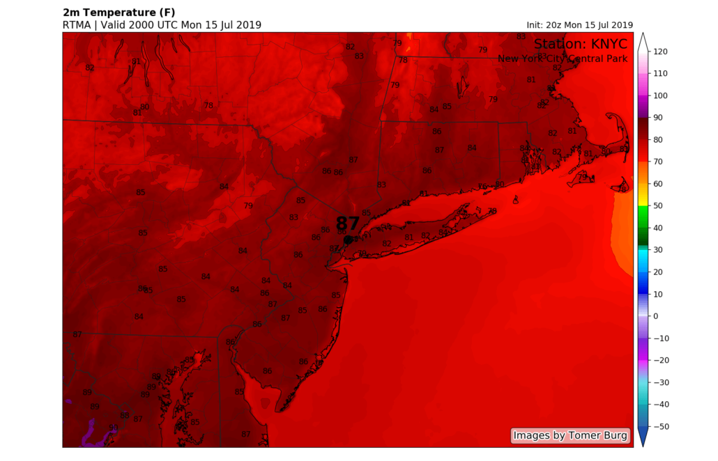
Snapshot of highs from this afternoon showing warm/hot conditions continuing across the NYC area
Conditions across the metro turn hot and unsettled by midweek
The first half of tomorrow (Tuesday) will likely be a carbon copy of the past five or so days. Skies will start off rather clear with warm temperatures and light winds. Temps should have no problem rising into the middle to upper 80’s once again, with 90’s possible over NE NJ. While tomorrow likely will not turn out to be one of the unbearably hot days, it still will be warmer than average. Dew points should hold right in the “manageable” levels, keeping heat indices down in the lower 90’s for much of the area. Issues begin to arise later in the day as some moisture from the remnants of Barry edge into our area. Humidity levels will rise considerably during the evening hours, with a chance of some showers and storms mainly to the west of the city. Otherwise, a very warm & muggy evening is expected with lows only dropping back into the middle 70’s!
Wednesday looks to be the first in a series of truly hot and unpleasant days. Moisture from Barry will continue to funnel into our area, really adding a “tropical” feel to the day. Warm temps, light winds, and the mostly clear skies should allow highs to get into the lower to middle 90’s across the entire area. The added tropical humidity will add to our misery, with heat indices peaking in the upper 90’s to right around 100 across NE NJ. Any relief in the form of showers and thunderstorms look to hold off until the late afternoon/evening hours.
Any storms that develop will likely remain disorganized and below severe thresholds, but heavy rain is certainly a concern. Precipitable water values will be in excess of 2″, meaning any stronger thunderstorm activity could create localized flash flooding. Lows Wednesday night will be quite uncomfortable with temps in the middle 70’s likely.
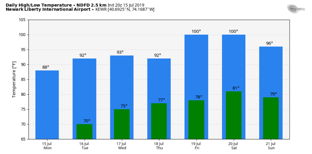
NWS forecasted highs showing a prolonged period of 90’s likely with a least two chances of breaking the 100-degree mark
Heat and humidity woes likely to continue into the weekend
It appears that Thursday may be the only day that we are spared somewhat from pure oppressive heat. The remnants of Hurricane Barry look to slowly move through during the day, with widespread showers and thunderstorms possible. Again, the main threat during this time will be the potential for very heavy rainfall rates & flash flooding. Despite unsettled conditions, temps will likely peak in the upper 80’s to lower 90’s with tropical levels of humidity on Thursday.
Things really become downright miserable by Friday when the core of this heatwave begins to impact the area. Highs on Friday will likely peak in the middle to upper 90’s across the entire NYC metro. Some locations across NE NJ may be able to break that 100-degree mark during peak heating. Dew points in the lower 70’s will support heat indices around 105-110 degrees, which will create hazardous conditions for those spending a prolonged period of time outside.
Saturday will also be another scorcher, with middle to upper 90’s likely. Heat indices have a good chance of reaching into the 100-105 range, likely requiring an Excessive Heat Watch from the NWS. Unfortunately, very hot and very humid conditions are likely through at least Sunday. While there are some signs this heatwave will break next week, this will be revisited in a later update.
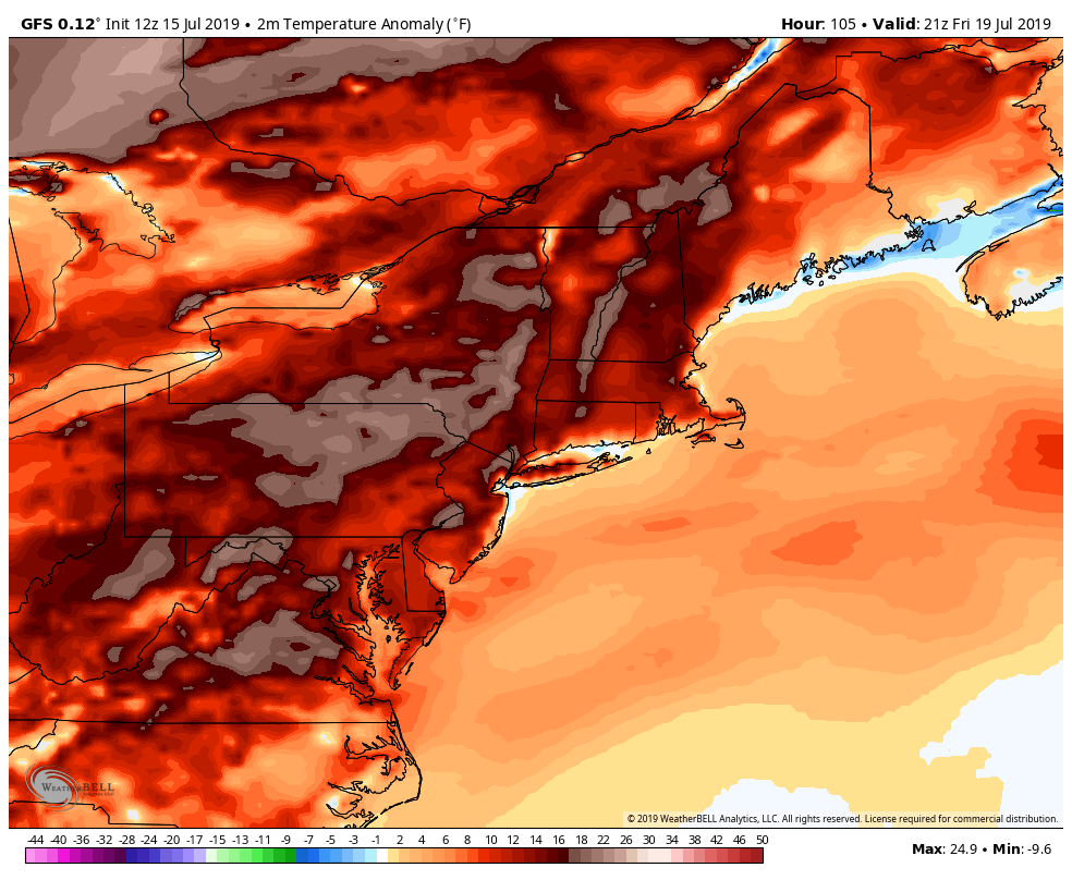
Afternoon GFS 2m temperature anomalies showing temps running anywhere from 15-25 degrees above normal by Friday!
Have a great night and stay cool! We’ll have updates all week on the impending heatwave!
-Steve Copertino
Trackbacks & Pingbacks
1potentially
Leave a Reply
Want to join the discussion?Feel free to contribute!