-2")

Seasons first snowfall expected in NYC, worst stays in the interior
A significant winter storm will impact the Northeast and parts of the Mid Atlantic from Sunday through Tuesday morning, with multiple rounds of snow expected. The heaviest snow is expected to fall in interior portions of the Northeast and throughout New England. The storm systems evolution remains extremely complex and will present forecasting challenges right up until snow is falling.
The event itself is anomalous in regards to its track. The storm systems story began over the Dakotas, where blizzard conditions were occurring this morning. Storms that track there typically move into Canada and produce warmer, rainier conditions in our area. This one, however, will be deflected southward by a large ridge of high pressure in Central Canada.
The “deflection” will redirect the storm system towards the Great Lakes, and then allow it to redevelop off the Mid Atlantic Coast. This will create a multi-phased system and a forecast headache. Here’s how we expect the whole thing to transpire:
Phase 1: Sunday into Sunday Night
A band of precipitation, associated with the main surface low over the Great Lakes, will move into Pennsylvania and New Jersey on Sunday. Precipitation should begin as snow during the late morning and early afternoon. As time goes on, a mid level warm layer is expected to expand. This will melt snowflakes as they fall toward the ground, changing the observed precipitation type to sleet or freezing rain. Eventually precipitation will change to all rain by Sunday evening in most of NJ and the NYC Metro
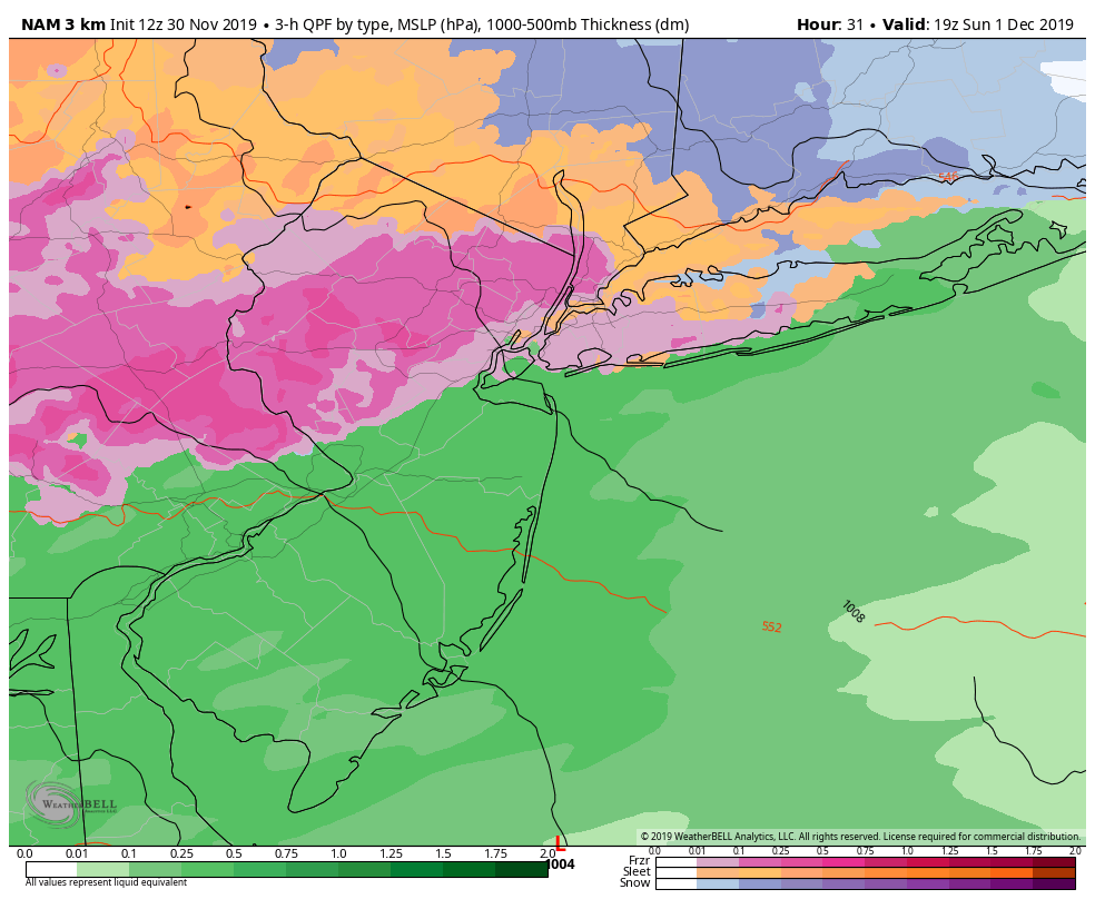
A few inches of snow are possible before the change, but our current expectation is that the most notable accumulations will be reserved to the interior and higher elevations. Accumulations in the NYC Metro area should be light and/or nominally impactful.
Phase 2: Monday into Monday Night
After changing to rain/drizzle, bands of precipitation will move off to the Northeast into New England. As this occurs, a coastal storm will begin to strengthen. Our area will lie within a mid level dry slot – which is what it sounds like, an area of dry air in the mid levels of the atmosphere. This should keep steady precipitation at bay. Instead, we’ll be looking at mostly drizzle or light mixed precipitation late Sunday into early Monday morning.
As the storm system strengthens off the coast, dynamics will increase once again. This will lead to the redevelopment of banding. Temperatures are expected to fall as cold air surges back in to the area. During this time, rain will transition back to snow. This will occur in the interior first, gradually transitioning towards the coast.

In interior locations, a few inches of additional snowfall are possible. Closer to the coast, and in the NYC Metro, snowfall accumulations are possible but will depend entirely on how fast the atmosphere can cool. As a result, confidence in any substantial accumulations is extremely low at this time. Eventually, bands of snow will slide northeast away from the area.
Summary, highlights and expectations
The current expectation is that this will be a very messy storm in the NYC Metro Area with multiple phases and mixed precipitation types. From a pure snowfall perspective, we do not expect this storm, system to be highly impactful especially within the immediate urban corridor from Newark to NYC. Our current forecast calls for a general 1-3” throughout the metro.
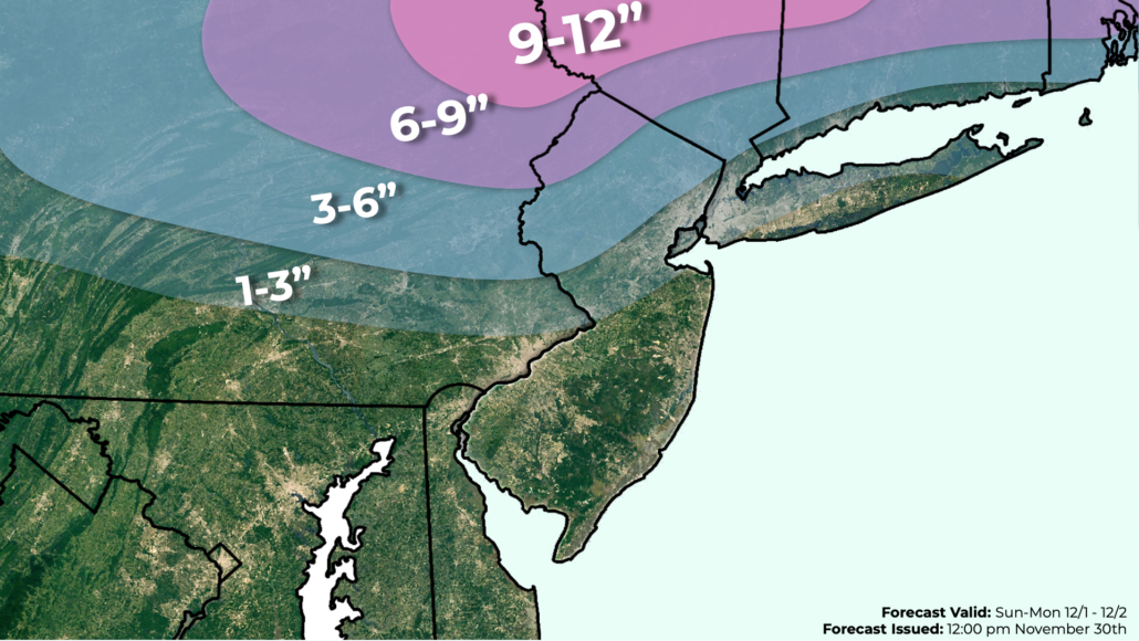
The impacts from this system will dramatically increase once one heads north or north/west of the NYC Metro Area into Northern NJ, Northeast PA, Southeast NY or CT. There, several inches of snowfall including sleet and freezing rain are likely. Most of those aforementioned areas will see a moderately impactful winter storm over the next two to three days.
Uncertainty remains quite high in regards to the systems exact impacts, and the potential exists for this forecast to change. Our official storm total snowfall forecast is above, but we will continue to tweak/change the numbers as the system approaches.
Leave a Reply
Want to join the discussion?Feel free to contribute!