Tropical Storm Jerry strengthens, recurve not a guarantee

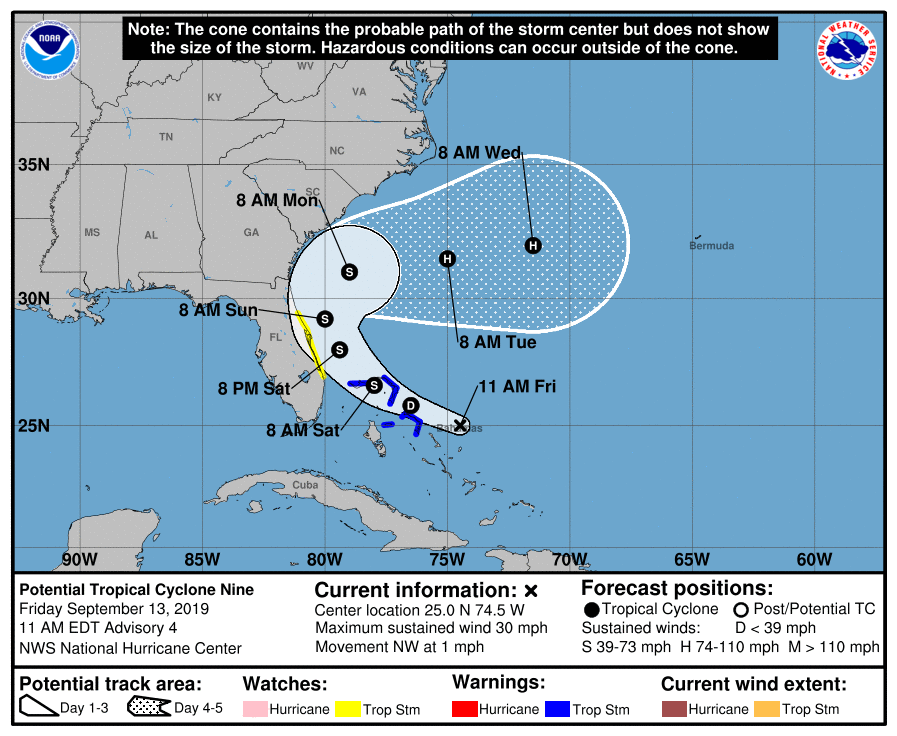
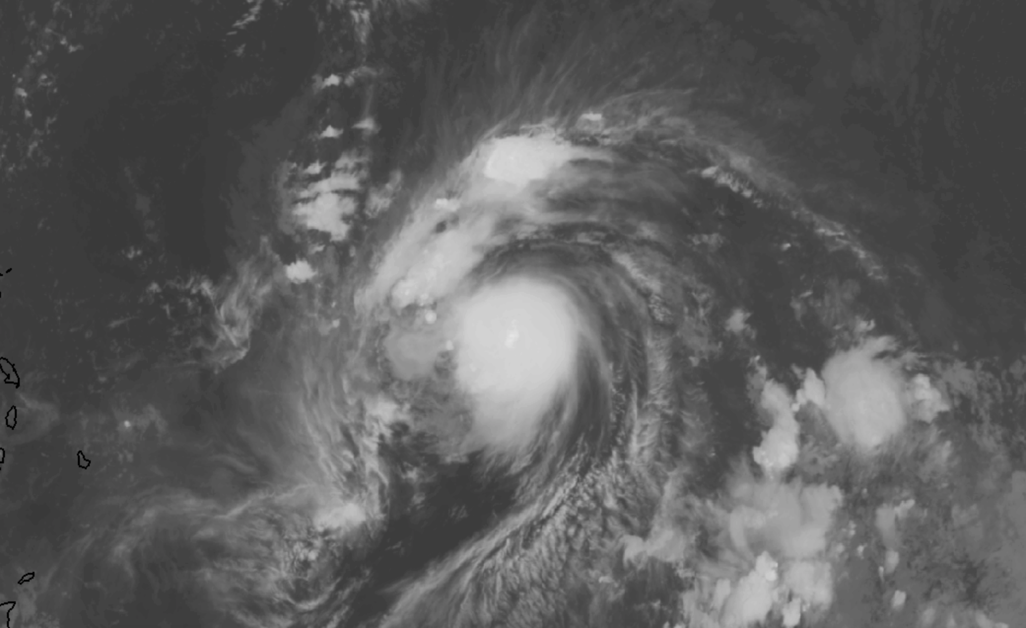
Tropical Storm Jerry strengthened again today, with maximum sustained winds now at 60 miles per hour. The storm is moving steadily northwestward in the Tropical Atlantic Ocean. It is expected to move north of the Antilles later this week, while strengthening into a hurricane.

Latest IR Satellite imagery of Tropical Storm Jerry located over the Central Atlantic with sustained winds of 60 mph

The eventual track of the cyclone remains uncertain. Most forecast models and ensembles suggest the highest probability scenario is that the system will curve northward and into the open Atlantic. A nontrivial amount of ensemble members, however, suggest the storm could track further south – closer to the Caribbean Islands.

Uncertainty rooted in Jerry’s strength

Often times, a large spread in potential solutions or tracks can be overwhelming. For meteorologists and weather forecasters alike, it is important to try and understand the root of these differences. In other words, what is causing each ensemble member to act differently than the others?

In this situation, there are two clear camps in regards to the track of Jerry over the next 5 days. One group (a larger amount of ensembles) take the storm further north and eventually curve it out to sea. Another group (smaller amount of ensembles) take the storm further south, toward the Caribbean Islands.

12z ECMWF Ensemble members showing the potential tracks for Jerry over the next four days. Note the stronger members (darker colors) are further south.

The members which are further south with Jerry have one thing in common: They are stronger with the storm system over the next 48 hours. The stronger, more organized system responds differently to its surroundings and pushes further southward as a result. The northward members allow the system to drift northward and eventually recurve.

As you may imagine, it will be critical to monitor the storms organization over the next 48-72 hours. We’ll be watching both the organization of the storm and trends among the medium range weather models. Confidence in regards to the storms track should begin to increase steadily thereafter.

Stay tuned for updates over the next few days as the eventual fate of Tropical Storm Jerry becomes more clear.

Prolonged stretch of warm, dry weather expected in NYC

An expansive high pressure system will build over New England beginning today, leading to a prolonged period warm and dry weather in the Northeast. Temperatures are likely to average a few degrees above normal over the next week, with very little threat of substantial precipitation or significant storms.

Read more

Weekend Outlook: Comfortable weather, watching PTC9

Beautiful, lower humidity air has moved into the Northeast this morning in the wake of a frontal boundary. It comes as a great relief after temperatures and humidity skyrocketed to midsummer levels on Thursday. Comfortable air is expected to remain in place through this evening.

Dew points will gradually rise again as we move through Saturday, although the weather will stay mostly pleasant for the majority of the day. As we move into the evening, a storm system will approach the area from the west. Clouds will increase, as will the opportunity for showers and storms.

These are expected to hold off until the evening hours, but will be fairly widespread in coverage when they move through from later Saturday into Sunday morning. Instability will remain quite low, so we aren’t anticipating a severe weather threat. Instead, showers will be capable of producing briefly heavy downpours as they move through.

The weather improves again on Sunday, with low humidity and sunshine returning. Attention will then turn to a period of unsettled weather during the middle part of next week, as well as the potential future of PTC9, which is still located in the Bahamas.

PTC9 still not organized this morning

The NHC declared Potential Tropical Cyclone 9 (PTC9) on Thursday evening, but the system has remained unorganized this morning and is yet to form a coherent center. The official NHC forecast still takes the storm toward the coast of Florida, but then begins to recurve it off the Southeast Coast.

Most reliable model guidance suggests that the storm will strengthen into a Tropical Storm at some point this weekend, but exactly when that occurs remains uncertain. Forecast model guidance is also split in regards to the systems track, and much of that stems back to when exactly the storm organizes.

Latest NHC Forecast for PTC 9

Once the storm moves off the Southeast US coast, it could potentially be blocked from moving seaward by a large high pressure to the north. This will create additional uncertainty as to the storms track and speed, potentially leaving it meandering off the coast for a few days.

Stay tuned for further updates as we move through the weekend – and most importantly, enjoy the day today!

NHC initiates advisories on PTC 9 in the Bahamas

The National Hurricane Center has initiated advisories on Potential Tropical Cyclone (PTC) 9 this evening. The area of organizing thunderstorms is located in the Bahamas, and is expected to drift northwestward over the next day or so while continuing to organize.

Read more