Heat Wave Early This Week, Unsettled Weather Late Week

After a couple beautiful days at the end of last week, more summer-like weather has returned this weekend with warmer and more humid conditions. The heat and humidity will only continue to become more oppressive during the early part of this week, as a strong 594dm ridge builds over the Eastern US. This will likely lead to the second heat wave of the season for the New York City metro area.

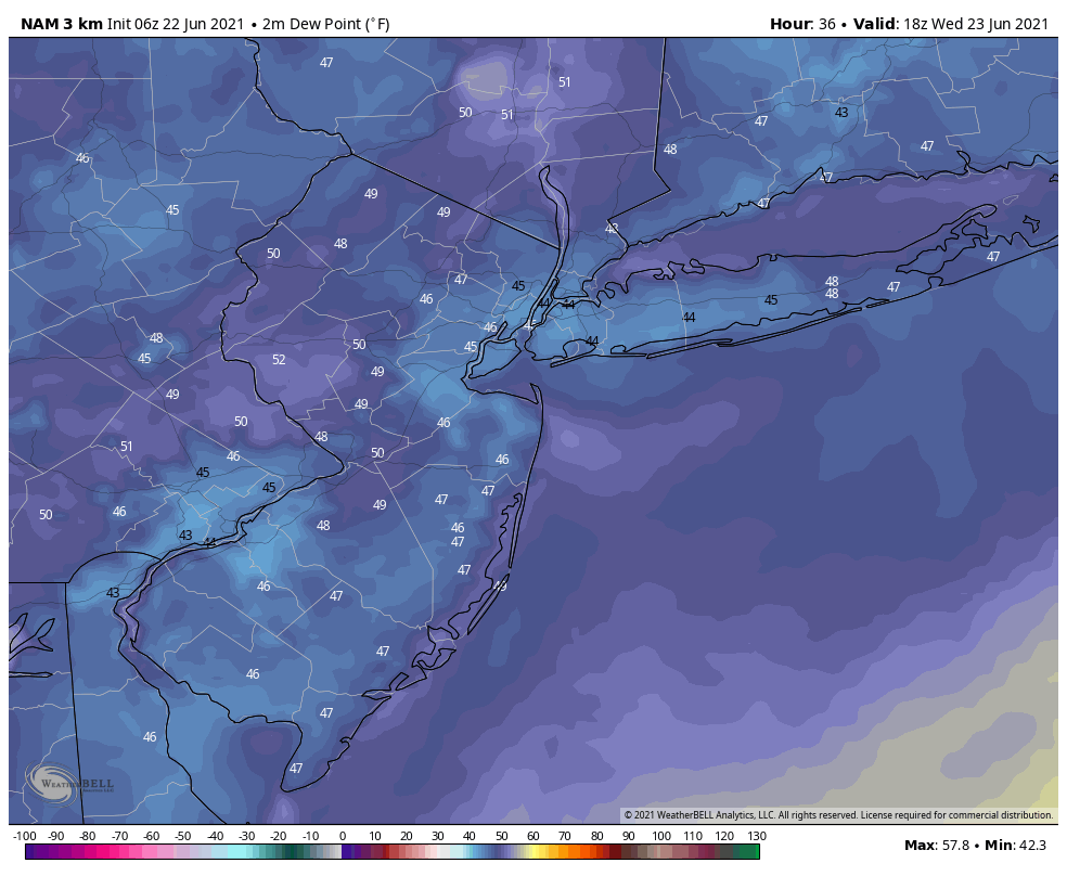
On Monday and Tuesday, high temperatures will reach the lower or middle 90s over New York City metro and New Jersey with southwest winds. Humidity will make those temperatures feel more oppressive with heat index values likely reaching between 100° to 104°F. Therefore, the National Weather Service has issued Heat Advisories for much of the region. Stay hydrated by drinking plenty of fluids and avoiding any strenuous activity outside.
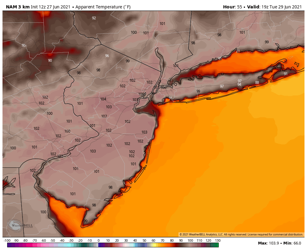
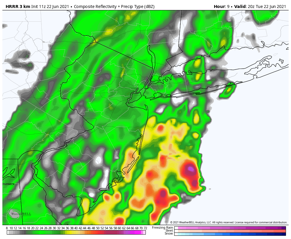
There will be little relief from the heat to find in the region. Temperatures will be a little cooler with sea-breezes along coastal locations, but humidity will still be oppressive. The heat and humidity could also lead to some isolated or widely-scattered showers and thunderstorms popping up each afternoon, before diminishing early in the evening.

The heat wave will continue on Wednesday with high temperatures in the low to mid 90s and humidity remaining oppressive. But a cold front associated with an upper-level trough will begin to approach from the Great Lakes later in the day. This could help to trigger more organized showers and thunderstorms during the afternoon and evening hours.

Then later in the week, the upper-level trough begins to dig deeper and break down the ridge over the Eastern US. The heat wave will likely break, but showers and thunderstorms may become more numerous and widespread over the region on Thursday and Friday. A strong southwesterly jet with abundant moisture feeding out of the Gulf of Mexico and Atlantic, could also result in result in higher risk for heavy rainfall and/or severe weather each day.
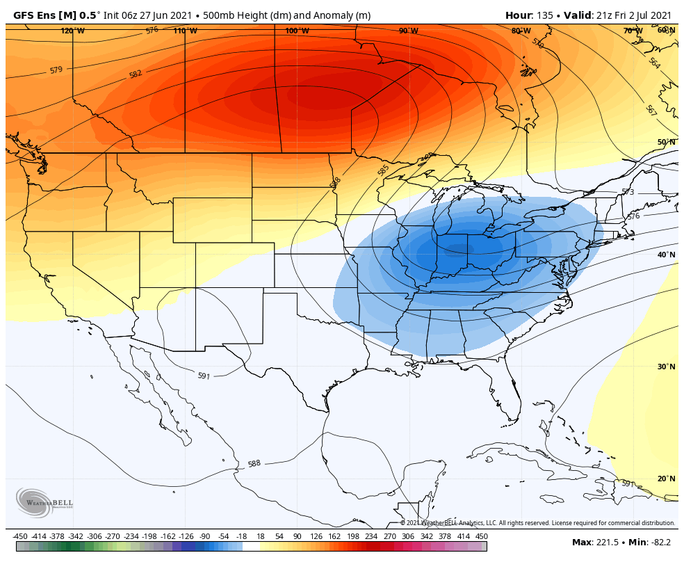
The latest guidance suggests that the upper-level trough will slow down and develop into a large cut-off low over the Eastern US. This could lead to more unsettled weather with some cooler temperatures for the July 4th weekend. However, there is uncertainty with model run to run differences on how this cut-off low will exactly evolve. Thus, we aren’t anticipating any washouts for the holiday weekend yet. We will have another update with more details on that forecast later in the week.

More Showers Today, Beautiful Weather Returns Wednesday

Unsettled weather conditions will continue today, as a cold front continues to move through the region. Skies will become mostly cloudy, and showers will begin arriving later this morning. These showers will continue for much of the afternoon and some heavy downpours are possible with a very moist airmass still in place.

Some isolated thunderstorms are also possible, but cloud cover will likely keep instability on the low side for any severe weather today. High temperatures in the 70s or lower 80s will likely be reached this morning before falling into the 60s with more clouds and showers this afternoon.

Latest HRRR model showing numerous showers and few isolated storms this afternoon

Showers will taper off late this afternoon and early this evening in the region, as the cold front pushes offshore. High pressure will cause skies to clear later tonight with temperatures dropping into the 50s and humidity levels decreasing throughout the region.

Beautiful weather with mostly sunny skies and high temperatures in the mid-upper 70s are expected on both Wednesday and Thursday, as high pressure remains over the region. Humidity will be at very low, comfortable levels for this time of year. Get outside and enjoy it , it doesn’t get much better than this during the summertime around here.

The 3km NAM model showing dewpoints in the 40s on Wednesday afternoon!

As we move into Friday and the weekend, high pressure and upper-level ridging will build offshore with more return southwesterly flow developing over the region. This will cause a warming trend and will allow humidity to increase again. High temperatures will begin reaching the 80s on Friday and Saturday and perhaps around 90 in some areas by Sunday.

Chances for scattered showers and thunderstorms may increase again early next week, especially as another frontal boundary approaches the region. While storms will be possible, it will be warm and humid with a mix and sun and clouds for most of the time each day – in other words, not a washout.

Latest guidance suggests some very warm and humid conditions will remain into the middle of next week, as the high pressure and upper-level ridge offshore will be slow to break down.

Pleasant midweek, storms possible again Saturday

An active weather pattern is expected to continue across the Northeast US over the next week, with temperatures averaging slightly below normal. Troughing over Southeast Canada is to blame, as it will continue to deflect warmer temperatures away from the area and allow for low pressure systems to meander near the area.

Conditions are expected to remain mostly pleasant on Tuesday afternoon, although a few isolated to scattered showers and storms may develop. These are more likely in New England, north of the NYC Metro. Still, isolated showers and storms could produce brief periods of locally heavy rain. No severe weather threat is anticipated.

Read more