Very warm and humid conditions are expected today, with high temperatures will likely reach the be in the middle 80s in the NYC Metro. Initially, dense smoke from wildfires over the Western US and Canada will continue cause very hazy skies and reduce air quality for much of the day. Smoke will begin to clear out later today behind a front.
This frontal boundary could also trigger some strong or severe thunderstorms this afternoon. An elevated mixed layer in the atmosphere will support high instability at the surface. but cover from a decaying complex of thunderstorms over the Interior Northeast overnight could act to mitigate storm development. Where high instability occurs, shear and mid-level lapses are high enough to support thunderstorms rapidly organizing and intensifying.
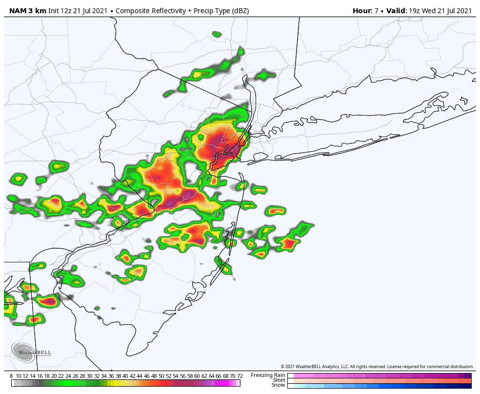
3km NAM model showing some strong thunderstorms over parts NYC metro between 2-4pm this afternoon
The Storm Prediction Center has placed most of the Tri-State area in a Slight Risk for severe thunderstorms today. A Severe Thunderstorm Watch will likely be issued this afternoon as well. The main threats from storms today will be strong, damaging wind gusts and large hail. Low-level winds not veering much with height will mitigate a tornado risk. Storms could also produce frequent cloud to ground lightning and flooding downpours.
These storms will exit the region early this evening. Then skies will clear of clouds and smoke overnight with temperatures dropping into the 60s and humidity lowering as well. Thursday and Friday will be more beautiful days with improved air quality. High temperatures will be in the mid 80s each day.
Humidity begins increasing on Saturday with high temperatures in low to mid 80s. Then Sunday will be very warm and humid again with highs in the upper 80s. A frontal system could bring more showers and thunderstorms on Sunday. But we don’t expect a washout.
https://www.nymetroweather.com/wp-content/uploads/2020/06/wojtek-witkowski-GtxZbYMCiPY-unsplash-scaled.jpg17002560Miguel Pierrehttps://www.nymetroweather.com/wp-content/uploads/2024/02/Empire-2000-x-300-px-2.pngMiguel Pierre2021-07-21 11:06:322021-07-21 11:30:00Strong Storms Possible Today, Smoke Clears Out Tonight
A frontal boundary and upper-level trough northwest of the area will begin to interact with Tropical Storm Elsa tracking northeast up the coast today. Scattered showers and thunderstorms will begin to develop around the region this afternoon and early this evening, with a muggy, unstable airmass in place. These storms could become strong or severe and capable of producing isolated damaging wind gusts or tornadoes, especially with stronger shear and forcing over the Interior areas.
Then the right-rear quadrant of an upper-level jet streak will begin to move closer and enhance forcing over more of the region. This will cause more widespread showers and thunderstorms to develop ahead of Tropical Storm Elsa later this evening. This process is also known as a Predecessor Rain Event, which occurs well in advance of a tropical system reaching the area. These showers and thunderstorms this afternoon through early tonight could contain torrential downpours and result in localized flash flooding.
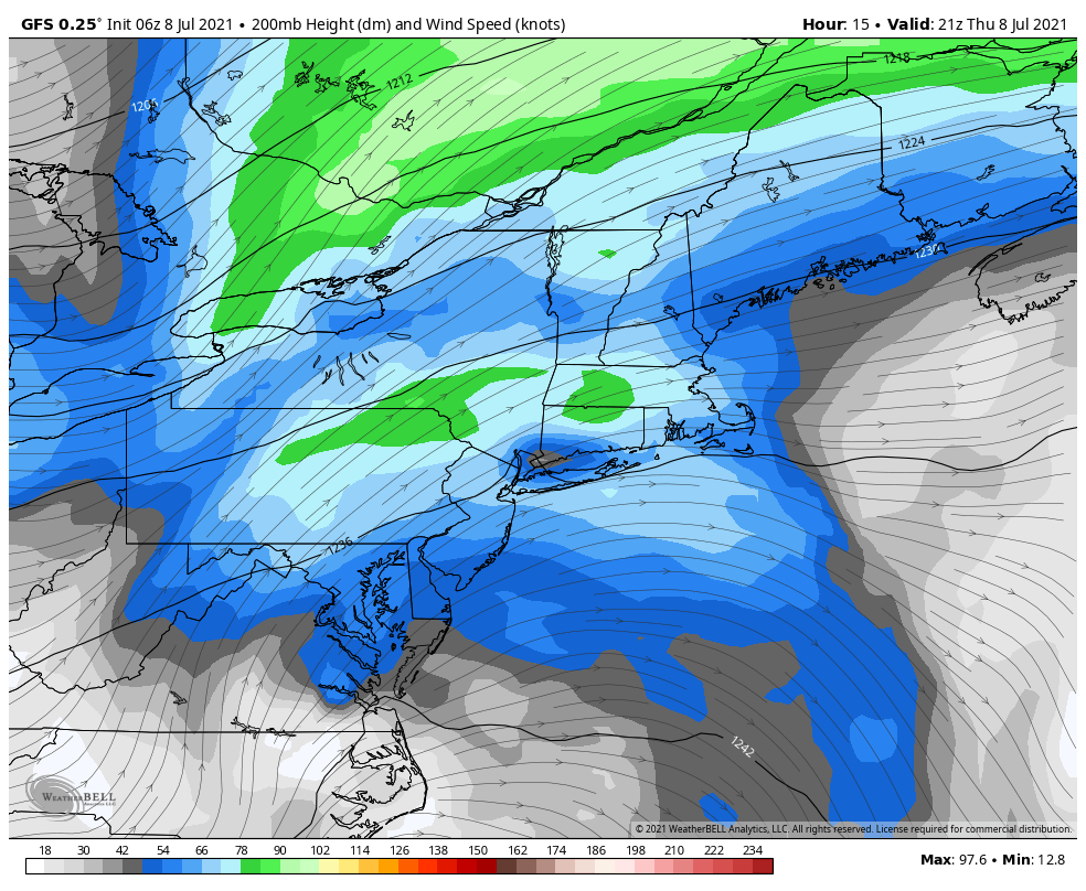
The GFS model shows the Northeast US right -rear quadrant of the upper-level jet, which will enhance rainfall ahead of Elsa
Tropical Storm Elsa is currently a minimal tropical storm with maximum sustained winds at 45 mph and is moving northeast at 20mph. Elsa could intensify more as a tropical storm tonight and tomorrow as it begins to phase with the upper-level jet streak. The exact track of Elsa will determine the amount of the impacts on the area. Tropical systems undergo baroclinic enhancement (phasing) the Mid-Atlantic and Northeast US, have the heaviest rains on the west side of the track and strongest winds on the east side.
The National Hurricane Center forecast and watches and warnings for Elsa
Based on the latest forecast track from the National Hurricane Center, which takes Elsa over Southeast New Jersey and Eastern Long Island, heavy rainfall and flash flooding will biggest threat for New York City metro and inland areas of New Jersey and Connecticut. A period of steadier, heavier rain with some gusty winds is likely very late tonight or Friday morning. Widespread rainfall totals between 2 to 4 inches and locally higher totals are likely by Friday afternoon. Flash flooding could occur on roadways and make for hazardous driving conditions. Never drive through flood waters!
The strongest winds from Elsa are most likely to occur late tonight and Friday morning over Long Island and coastal sections of New Jersey and Connecticut, where the Tropical Storm Warnings have been issued. Sustained winds could be between 40-50mph with gusts up to near 60mph for at least a few hours, as Elsa’s center passes nearby. These winds could cause tree damage and power outages. Around New York City, winds are likely to be between 20-30mph with some gusts to up to near 40mph possible.
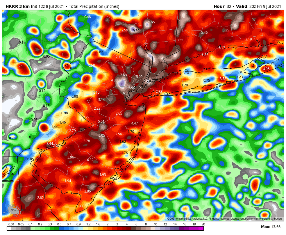
The HRRR models shows rainfall totals widespread 2″-4″ and locally up 6″ in the region
Tropical Storm Elsa will be tracking quickly through the region. So we don’t anticipate any significant storm surge or coastal flooding in the region. There is also a low risk for Elsa’s outer rain bands to produce a few isolated tornadoes or waterspouts, especially along coastal sections later tonight into Friday morning.
We will continue to monitor the latest developments with Elsa’s remnants until they depart the area quickly late Friday morning. Some scattered showers and thunderstorms may redevelop in the area Friday afternoon and evening with frontal boundary still nearby.
Overall, we aren’t expecting severe impacts from Elsa. But any changes in the current forecast track could result in heavier rains impacting coastal sections more or stronger winds further inland. Check back this briefing or on our social media accounts for more updates.
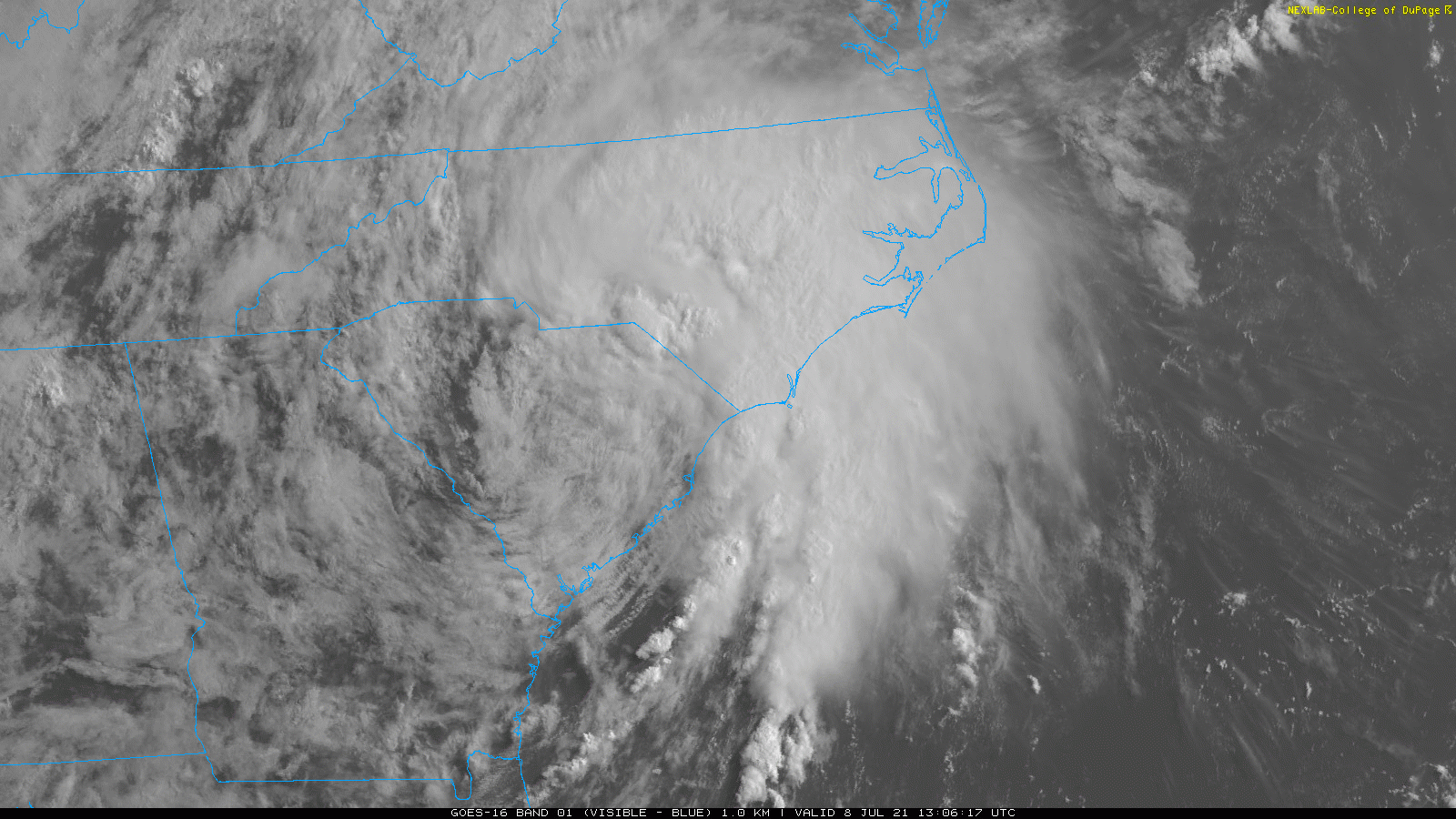
https://www.nymetroweather.com/wp-content/uploads/2021/07/Elsa-Visible-Image.gif9001600Miguel Pierrehttps://www.nymetroweather.com/wp-content/uploads/2024/02/Empire-2000-x-300-px-2.pngMiguel Pierre2021-07-08 11:17:172021-07-08 11:35:46Tropical Storm Elsa Impacts for the NYC Metro Area
Very hot and humid conditions return for today and Wednesday, as a southwest flow develops. High temperatures will reach the lower and middle 90s throughout much of the region. High dewpoints in the lower 70s will support heat index values reaching into the lower 100s, which will cause the heat to feel more oppressive. For this reason, the National Weather Service has issued Heat Advisories for much of the region, including the New York City metro area. Stay hydrated by drinking plenty of fluids and avoiding strenuous activity outdoors. Keep a close eye on the elderly, children and pets.
There is also potential for strong to severe thunderstorms later this afternoon and evening. An upper-level disturbance approaching the area will likely trigger clusters of showers and thunderstorms over the Upstate New York, Northwest New Jersey and Northeast Pennsylvania. These storms will track southeast into the New York City area by early this evening. The heat and humidity building under an elevated mixed-layer in the atmosphere will result in very high instability, which will support thunderstorms becoming intense.
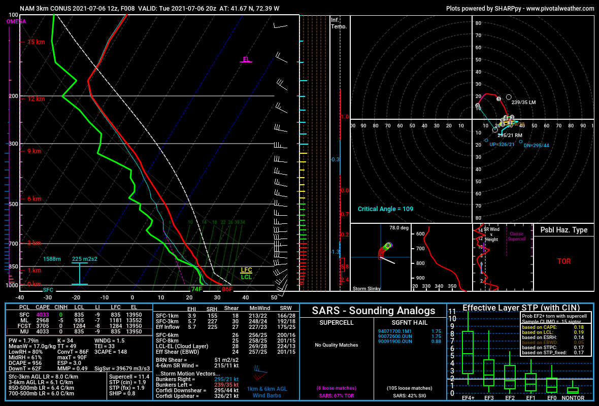
The high resolution NAM model shows showers and thunderstorms moving into the New York City early this evening.
Therefore, the Storm Prediction Center has placed most of the region under a Slight Risk for severe thunderstorms today. The main threat from these storms is likely to be strong, gusty or damaging winds. Storms are likely TO produce torrential downpours which could cause localized flash flooding, frequent cloud to ground lightning and perhaps some hail.
A lack of strong, deep-layered shear will likely mitigate a tornado risk. But we will need to monitor any localized areas where low-level flow backs more to the south, particularly over parts of Connecticut. That could cause a thunderstorm to rotate and produce an isolated tornado. The model sounding below demonstrates this potential.
Sounding from the high-resolution NAM model over Connecticut later this afternoon
On Wednesday, a cold front and upper-level trough will begin approaching from the Great Lakes region and instability will build again. This could trigger scattered showers and thunderstorms during the afternoon or evening hours. With weaker shear and forcing over the region, the risk for strong to severe thunderstorms is likely to be more isolated. Therefore, Storm Prediction Center has currently only placed parts of the region under a Marginal Risk for some isolated severe thunderstorms with damaging wind gusts.
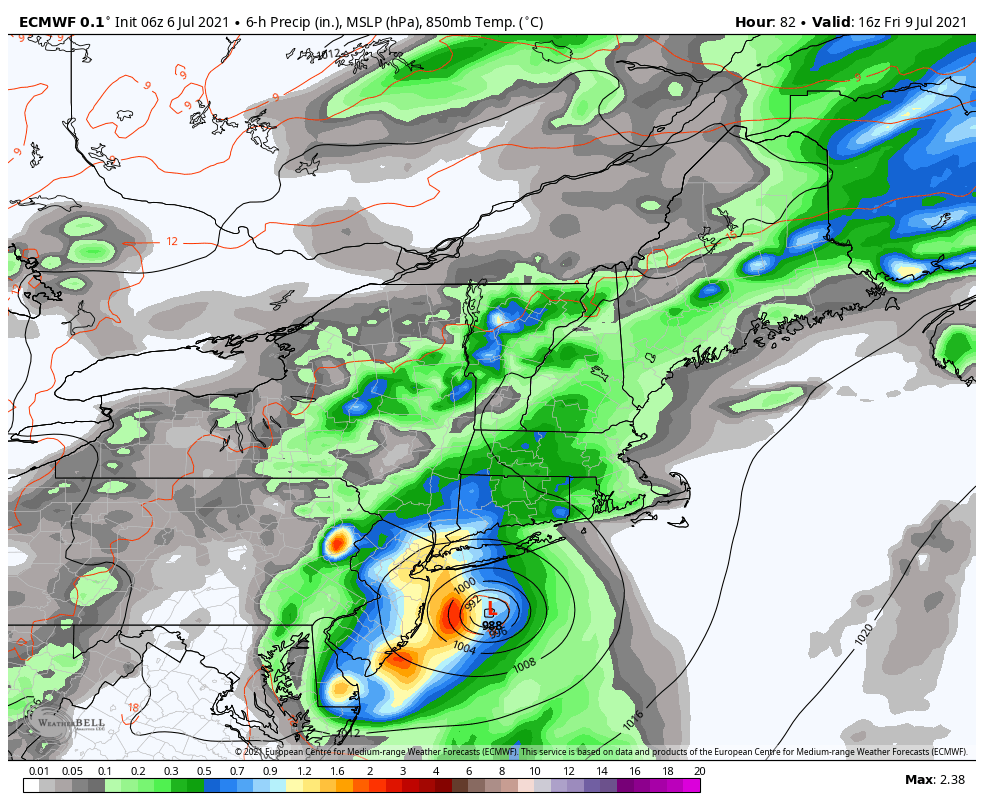
Weather conditions look more unsettled and somewhat cooler on Thursday and Friday. The cold front and upper-level trough will slow down and interact with Tropical Storm Elsa’s remnants from over the Southeast US. This pattern will at least produce more clouds with perhaps some scattered showers or thunderstorms over the region. There is more uncertainty on how much direct impacts there will be from Elsa’s remnants, which will likely track near or southeast of the New York City metro area.
The ECMWF model showing the remnants of Tropical Storm Elsa bringing heavy rainfall to parts of the region by Friday.
One possibility is that Elsa tracks close enough with it’s tropical moisture and enhances more widespread heavy rainfall and flash flooding over the region. This solution is currently supported by ECMWF model and many of it’s ensembles. Another possibility is that sinking air around Elsa tracking further southeast keeps much of the region drier. This solution has still some support from other model guidance. We will continue to monitor the latest guidance on Elsa remnants and provide more updates this week.
For this weekend, we expect more comfortable temperatures and humidity overall with the cold front to the south. High temperatures will be below normal in the upper 70s and lower 80s. Another disturbance passing by to the south may produce some showers in the region by Sunday.
https://www.nymetroweather.com/wp-content/uploads/2020/06/patrick-tomasso-SVVTZtTGyaU-unsplash-scaled.jpg17052560Miguel Pierrehttps://www.nymetroweather.com/wp-content/uploads/2024/02/Empire-2000-x-300-px-2.pngMiguel Pierre2021-07-06 10:54:312021-07-06 11:46:49Heat & Humidity Returns with Severe Storms Possible Today, Elsa’s Remnants Late Week?
Hi friends! Our website uses cookies to provide an optimal browsing experience for you. New "Cookie Consent" laws mandate us to inform you of this. As long as you're cool with it, just hit OK. You'll only see this message once.
We may request cookies to be set on your device. We use cookies to let us know when you visit our websites, how you interact with us, to enrich your user experience, and to customize your relationship with our website.
Click on the different category headings to find out more. You can also change some of your preferences. Note that blocking some types of cookies may impact your experience on our websites and the services we are able to offer.
Essential Website Cookies
These cookies are strictly necessary to provide you with services available through our website and to use some of its features.
Because these cookies are strictly necessary to deliver the website, refusing them will have impact how our site functions. You always can block or delete cookies by changing your browser settings and force blocking all cookies on this website. But this will always prompt you to accept/refuse cookies when revisiting our site.
We fully respect if you want to refuse cookies but to avoid asking you again and again kindly allow us to store a cookie for that. You are free to opt out any time or opt in for other cookies to get a better experience. If you refuse cookies we will remove all set cookies in our domain.
We provide you with a list of stored cookies on your computer in our domain so you can check what we stored. Due to security reasons we are not able to show or modify cookies from other domains. You can check these in your browser security settings.
Other external services
We also use different external services like Google Webfonts, Google Maps, and external Video providers. Since these providers may collect personal data like your IP address we allow you to block them here. Please be aware that this might heavily reduce the functionality and appearance of our site. Changes will take effect once you reload the page.
-2")