Heat & Humidity Returns with Severe Storms Possible Today, Elsa’s Remnants Late Week?

Very hot and humid conditions return for today and Wednesday, as a southwest flow develops. High temperatures will reach the lower and middle 90s throughout much of the region. High dewpoints in the lower 70s will support heat index values reaching into the lower 100s, which will cause the heat to feel more oppressive. For this reason, the National Weather Service has issued Heat Advisories for much of the region, including the New York City metro area. Stay hydrated by drinking plenty of fluids and avoiding strenuous activity outdoors. Keep a close eye on the elderly, children and pets.

There is also potential for strong to severe thunderstorms later this afternoon and evening. An upper-level disturbance approaching the area will likely trigger clusters of showers and thunderstorms over the Upstate New York, Northwest New Jersey and Northeast Pennsylvania. These storms will track southeast into the New York City area by early this evening. The heat and humidity building under an elevated mixed-layer in the atmosphere will result in very high instability, which will support thunderstorms becoming intense.
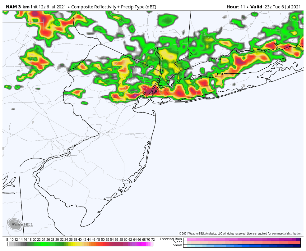
Therefore, the Storm Prediction Center has placed most of the region under a Slight Risk for severe thunderstorms today. The main threat from these storms is likely to be strong, gusty or damaging winds. Storms are likely TO produce torrential downpours which could cause localized flash flooding, frequent cloud to ground lightning and perhaps some hail.

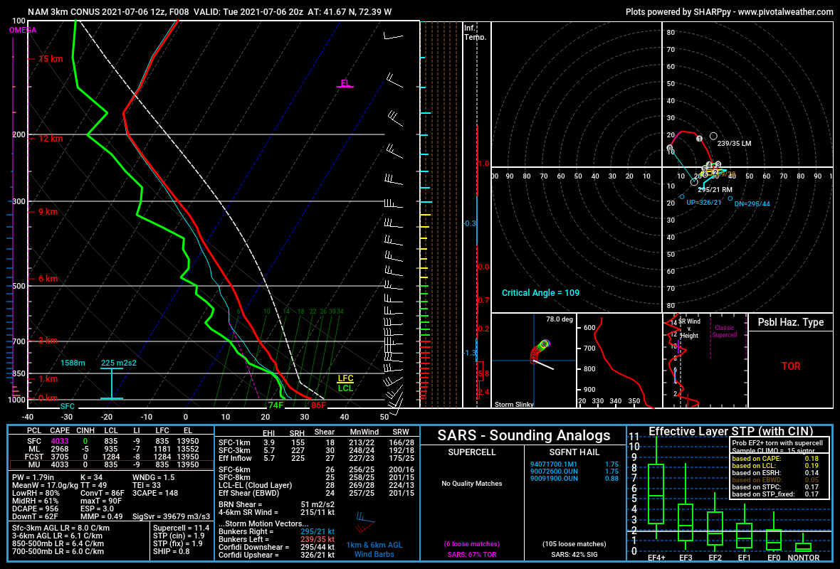
A lack of strong, deep-layered shear will likely mitigate a tornado risk. But we will need to monitor any localized areas where low-level flow backs more to the south, particularly over parts of Connecticut. That could cause a thunderstorm to rotate and produce an isolated tornado. The model sounding below demonstrates this potential.

Sounding from the high-resolution NAM model over Connecticut later this afternoon

On Wednesday, a cold front and upper-level trough will begin approaching from the Great Lakes region and instability will build again. This could trigger scattered showers and thunderstorms during the afternoon or evening hours. With weaker shear and forcing over the region, the risk for strong to severe thunderstorms is likely to be more isolated. Therefore, Storm Prediction Center has currently only placed parts of the region under a Marginal Risk for some isolated severe thunderstorms with damaging wind gusts.

Weather conditions look more unsettled and somewhat cooler on Thursday and Friday. The cold front and upper-level trough will slow down and interact with Tropical Storm Elsa’s remnants from over the Southeast US. This pattern will at least produce more clouds with perhaps some scattered showers or thunderstorms over the region. There is more uncertainty on how much direct impacts there will be from Elsa’s remnants, which will likely track near or southeast of the New York City metro area.

The ECMWF model showing the remnants of Tropical Storm Elsa bringing heavy rainfall to parts of the region by Friday.

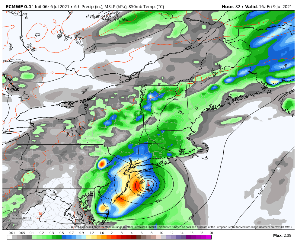
One possibility is that Elsa tracks close enough with it’s tropical moisture and enhances more widespread heavy rainfall and flash flooding over the region. This solution is currently supported by ECMWF model and many of it’s ensembles. Another possibility is that sinking air around Elsa tracking further southeast keeps much of the region drier. This solution has still some support from other model guidance. We will continue to monitor the latest guidance on Elsa remnants and provide more updates this week.

For this weekend, we expect more comfortable temperatures and humidity overall with the cold front to the south. High temperatures will be below normal in the upper 70s and lower 80s. Another disturbance passing by to the south may produce some showers in the region by Sunday.

Heat Wave Early This Week, Unsettled Weather Late Week

After a couple beautiful days at the end of last week, more summer-like weather has returned this weekend with warmer and more humid conditions. The heat and humidity will only continue to become more oppressive during the early part of this week, as a strong 594dm ridge builds over the Eastern US. This will likely lead to the second heat wave of the season for the New York City metro area.

On Monday and Tuesday, high temperatures will reach the lower or middle 90s over New York City metro and New Jersey with southwest winds. Humidity will make those temperatures feel more oppressive with heat index values likely reaching between 100° to 104°F. Therefore, the National Weather Service has issued Heat Advisories for much of the region. Stay hydrated by drinking plenty of fluids and avoiding any strenuous activity outside.

There will be little relief from the heat to find in the region. Temperatures will be a little cooler with sea-breezes along coastal locations, but humidity will still be oppressive. The heat and humidity could also lead to some isolated or widely-scattered showers and thunderstorms popping up each afternoon, before diminishing early in the evening.

The heat wave will continue on Wednesday with high temperatures in the low to mid 90s and humidity remaining oppressive. But a cold front associated with an upper-level trough will begin to approach from the Great Lakes later in the day. This could help to trigger more organized showers and thunderstorms during the afternoon and evening hours.

Then later in the week, the upper-level trough begins to dig deeper and break down the ridge over the Eastern US. The heat wave will likely break, but showers and thunderstorms may become more numerous and widespread over the region on Thursday and Friday. A strong southwesterly jet with abundant moisture feeding out of the Gulf of Mexico and Atlantic, could also result in result in higher risk for heavy rainfall and/or severe weather each day.

The latest guidance suggests that the upper-level trough will slow down and develop into a large cut-off low over the Eastern US. This could lead to more unsettled weather with some cooler temperatures for the July 4th weekend. However, there is uncertainty with model run to run differences on how this cut-off low will exactly evolve. Thus, we aren’t anticipating any washouts for the holiday weekend yet. We will have another update with more details on that forecast later in the week.

More Showers Today, Beautiful Weather Returns Wednesday

Unsettled weather conditions will continue today, as a cold front continues to move through the region. Skies will become mostly cloudy, and showers will begin arriving later this morning. These showers will continue for much of the afternoon and some heavy downpours are possible with a very moist airmass still in place.

Some isolated thunderstorms are also possible, but cloud cover will likely keep instability on the low side for any severe weather today. High temperatures in the 70s or lower 80s will likely be reached this morning before falling into the 60s with more clouds and showers this afternoon.

Latest HRRR model showing numerous showers and few isolated storms this afternoon

Showers will taper off late this afternoon and early this evening in the region, as the cold front pushes offshore. High pressure will cause skies to clear later tonight with temperatures dropping into the 50s and humidity levels decreasing throughout the region.

Beautiful weather with mostly sunny skies and high temperatures in the mid-upper 70s are expected on both Wednesday and Thursday, as high pressure remains over the region. Humidity will be at very low, comfortable levels for this time of year. Get outside and enjoy it , it doesn’t get much better than this during the summertime around here.

The 3km NAM model showing dewpoints in the 40s on Wednesday afternoon!

As we move into Friday and the weekend, high pressure and upper-level ridging will build offshore with more return southwesterly flow developing over the region. This will cause a warming trend and will allow humidity to increase again. High temperatures will begin reaching the 80s on Friday and Saturday and perhaps around 90 in some areas by Sunday.

Chances for scattered showers and thunderstorms may increase again early next week, especially as another frontal boundary approaches the region. While storms will be possible, it will be warm and humid with a mix and sun and clouds for most of the time each day – in other words, not a washout.

Latest guidance suggests some very warm and humid conditions will remain into the middle of next week, as the high pressure and upper-level ridge offshore will be slow to break down.

Pleasant midweek, storms possible again Saturday

An active weather pattern is expected to continue across the Northeast US over the next week, with temperatures averaging slightly below normal. Troughing over Southeast Canada is to blame, as it will continue to deflect warmer temperatures away from the area and allow for low pressure systems to meander near the area.

Conditions are expected to remain mostly pleasant on Tuesday afternoon, although a few isolated to scattered showers and storms may develop. These are more likely in New England, north of the NYC Metro. Still, isolated showers and storms could produce brief periods of locally heavy rain. No severe weather threat is anticipated.

Read more