Cooler air expected in the Northeast, Sally to impact Gulf Coast states

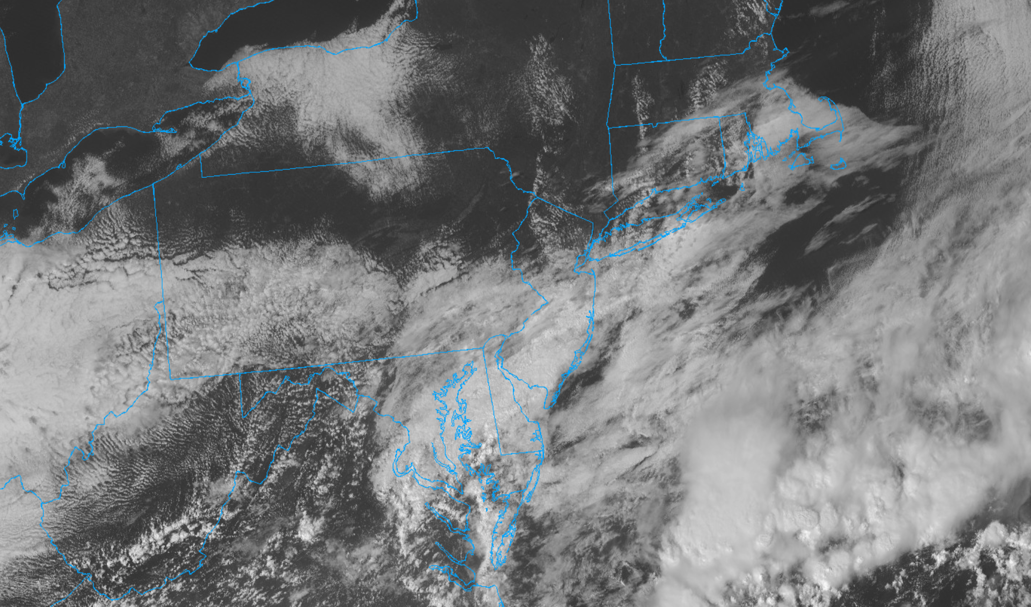
NYC Forecast Briefing: A few sprinkles or showers will move through the area this evening, but the majority of Sunday is now expected to be pleasant. Cooler than normal air will move in to the area for a few days behind a frontal boundary. Additional rounds of cooler than normal air will occur late this upcoming week and weekend. Meanwhile, Tropical Storm Sally continues its trek through the Gulf of Mexico and may impact parts of the Gulf Coast within a few days.

NYC QuickCast

This afternoon: Mostly pleasant conditions and seasonable temperatures are expected. Clouds will increase late. High temperatures will reach the middle to upper 70’s

Tonight: Cloudy with a few showers, especially north of the city. A bit warmer, with temperatures only falling into the middle 60’s.

Monday: Plenty of sunshine, less humid. High temperatures in the middle to upper 70’s with a light northerly breeze.

Northeast US Forecast: Cooler than normal air on the way

Behind a frontal boundary that will impact the area with some showers late Sunday evening, high pressure and cooler than normal air will move into the Northeast states. This airmass will also be characterized by lower dew points, helping the airmass feel refreshing and crisp.

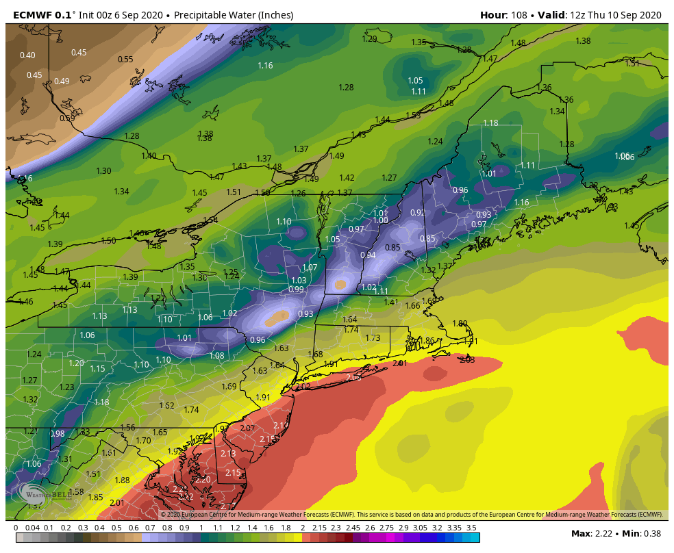
This airmass will last for at least a few days, with very pleasant weather likely as a result. High temperatures for the rest of the week should average in the low to mid 70’s, with plenty of sunshine and very few weather hazards as high pressure dominates.

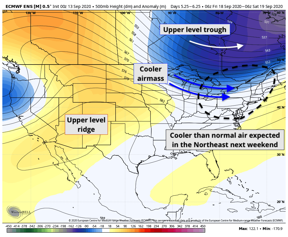
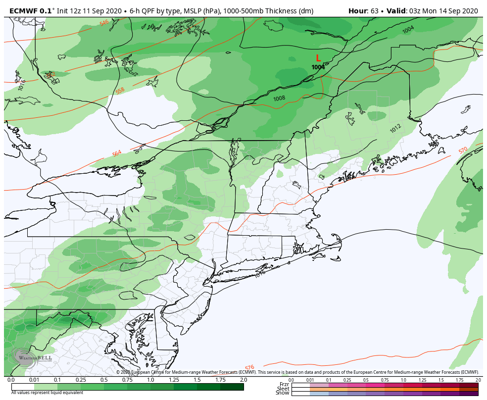
Temperatures will temporarily warm up again by the middle part of this week. A storm system moving through Southeast Canada and New England will eventually move near the area (likely from Thursday into Friday). A few showers are possible as this system passes by.

More importantly, though, the storm will bring the first really crisp airmass with it. After a front passes the area on Friday, much cooler than normal temperatures are likely next weekend. The last Euro Ensemble suggested temperatures 5-10 degrees below normal, on average, from Saturday into Monday.

Pictured above, a mid/upper level trough is forecast to slide through Southeast Canada. This trough is anomalous in its own right and features some very cool and low dewpoint air. Synoptically, this supports temperatures at least several degrees below normal for a few days in the Northeast next weekend – which matches up quite well with what most guidance is suggesting.

Get your pumpkin spiced lattes ready.

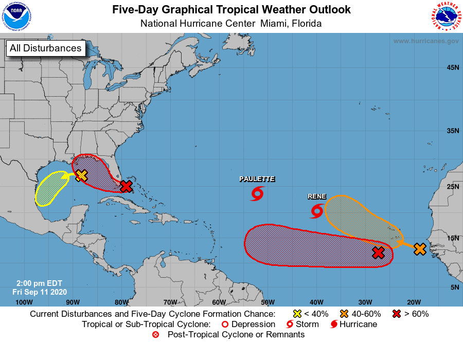
Tropical activity continues to ramp up, Sally a tropical storm

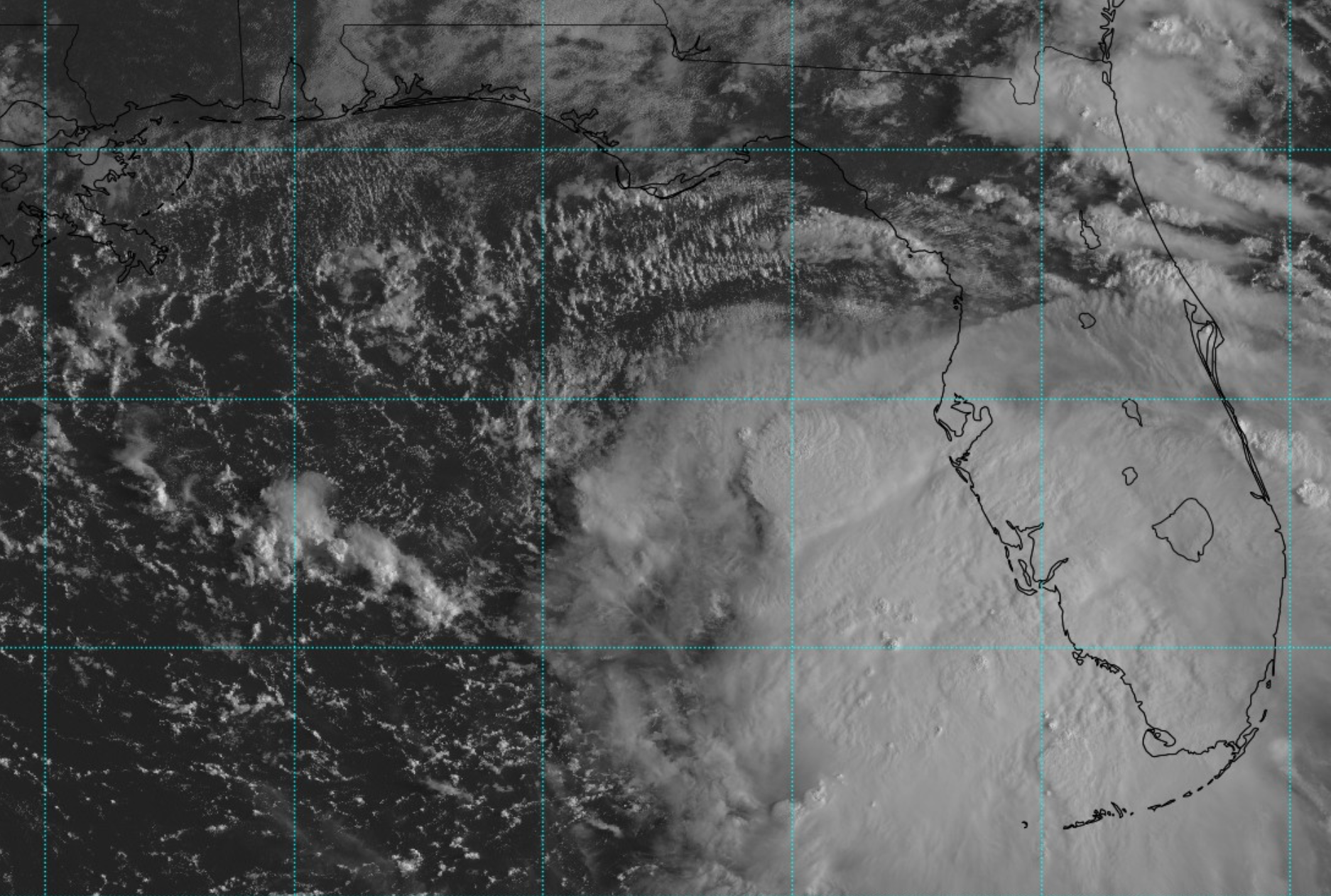
Tropical Storm Sally formed yesterday, and is expected to continue a trek into the northeast Gulf of Mexico today. The storm is currently encountering light to moderate northwesterly shear, which is tilting thunderstorms off to the east of the storms center. This is preventing the system from strengthening too much as of this morning.

The latest shear analysis near and surrounding the storm suggested 10-20 kts (averaging around 15 kts) of northwesterly wind shear. Visible satellite imagery shows that convection is biased to the southeast side of the storm, and this northwesterly shear is likely partially to blame for that.

Sally is also a very broad system, with tropical storm force winds extending quite a bit away from the center. This should also keep the system from strengthening significantly today, at least until the storm can organize a more substantial inner core and tighten up the spatial extend of its maximum wind.

This shear is expected to gradually weaken over the next 12 hours, so the storm may be able to organize itself a bit further. The National Hurricane Center forecasts the storm to strengthen to a hurricane before it makes landfall near the Louisiana coastline on Tuesday.

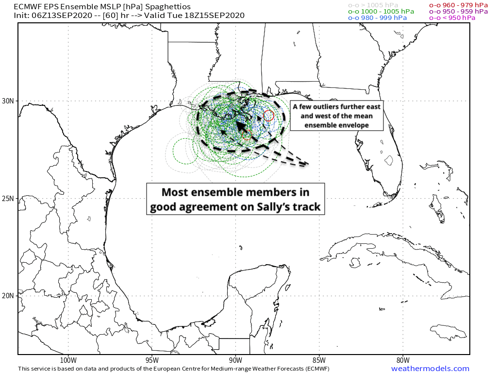
Most forecast model guidance is now in good agreement regarding the storms track and strength, with ensembles agreeing that the storm will move towards the Louisiana Coast as a Category 1 hurricane. Still, with relatively low shear and warm water temperatures, it is important to keep a close eye on the storms strength and possibly of intensification.

The 06z Euro Ensembles were in generally good agreement in regards to the storms track, bringing the system near the Louisiana coast early next week. Still, some members were stronger and slower with the storm – with deeper pressures indicative of a more substantial system.

Sally is likely to bring multiple weather hazards to the areas it impacts regardless of strength. The system is expected to slow down considerably, which will lead to a high likelihood of torrential, flooding rainfall. Sally remains trapped in a pocket of very moist air throughout the atmospheric column. This means that the system will not have much dry air to deal with, even in the mid levels of the atmosphere.

As Sally approaches the coast, steering flow will weaken and the storm will become “trapped” under a mid level ridge. This suggests that the system will slow down considerably near the Gulf Coast, while tropical moisture pools over the area. As a result, torrential and flooding rainfall is possible.

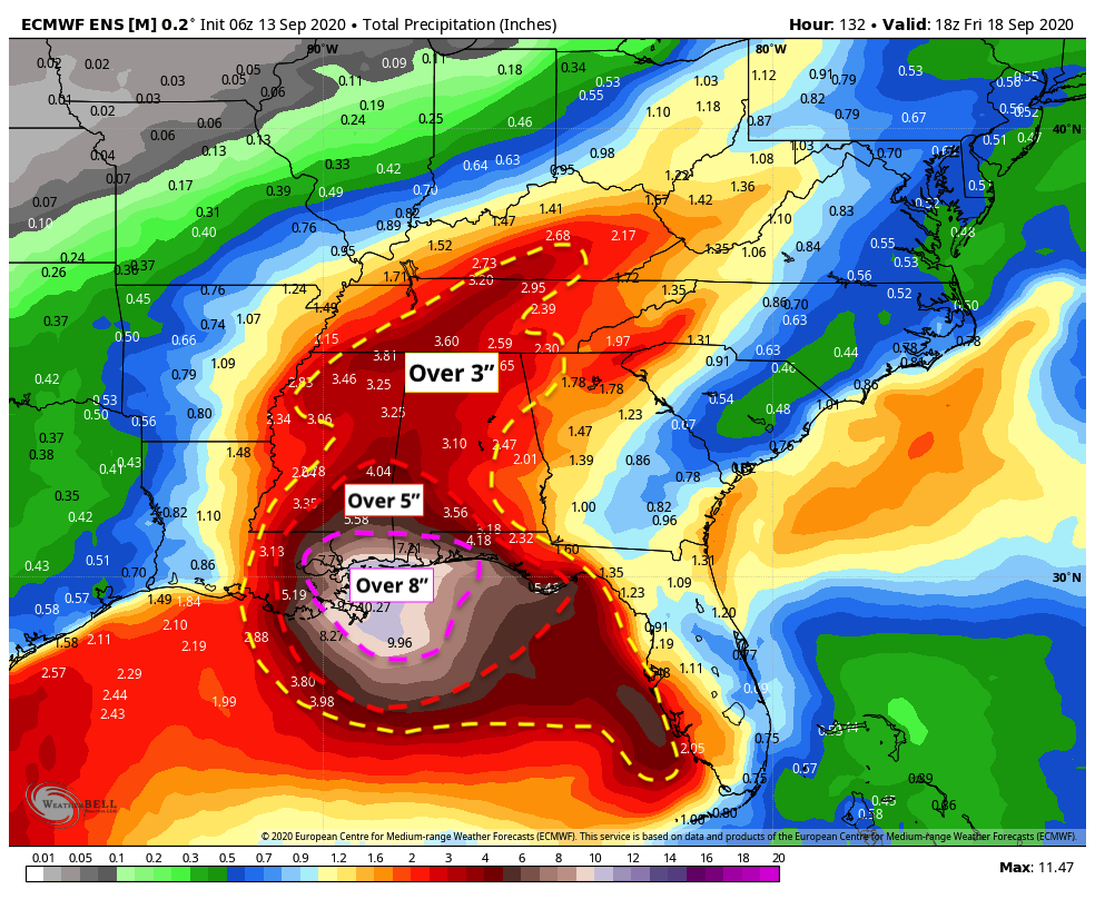
The Euro Ensemble is strongly suggesting the possibility of prolific rainfall amounts, with the ensemble mean suggesting over 10 inches of rain along parts of the coast. Actual amounts could be much higher than that in areas that receive “training” of tropical moisture – which occurs when areas of heavy rain move over the same regions over and over.

Additionally, some storm surge is possible as the system moves towards the Gulf Coast. The National Hurricane Center is forecast over 3 feet of storm surge in some areas that are highly susceptible to storm surge damage.

We recommend checking out the National Hurricane Center’s latest hazards page and key points in order to help develop a plan for you and your family if you live in those regions.

NYC Forecast: Showers Sunday, pleasant otherwise

Seasonable conditions are expected for the remainder of Friday and Saturday. Temperatures will average near or slightly below normal, with lower humidity. Showers are expected as a front approaches the area on Sunday. Pleasant weather will return next week.

QuickCast

This afternoon: Calm conditions are expected to continue with temperatures in the low to mid 70’s.

Tonight: Mostly clear with temperatures falling into the 50’s. Low dew points will keep the air feeling crisp and refreshing.

Saturday: Plenty of sunshine, with pleasant weather expected. High temperatures will reach the lower to middle 70’s once again. Clouds will increase later Saturday and Saturday evening.

Discussion: Showers Sunday, pleasant conditions return thereafter

Forecast models are in good agreement that a frontal boundary will approach the area on Sunday. This will lead to increasing clouds and showery conditions throughout much of the day. It remains to be seen exactly how quickly these showers actually approach the region, as recent model guidance has slowed the frontal boundary down. A slower frontal approach could mean showery/drizzly conditions, but no true steady rainfall on Sunday. Either way, showers are expected later Sunday night.

Showers will approach the area from the west later on Sunday evening.

Recent runs of the ECMWF, for example (pictured above) have continued a trend towards a later frontal passage. That trend has also been accompanied by a drier tendency, which is obviously good news if we hope to salvage Sunday. Forecast soundings show relatively limited moisture in the atmosphere until the front approaches, but that moisture is in the low levels. This suggests that cloudy and drizzly conditions are most likely on Sunday. When the front does approach, some periods of steadier rain are possible – but the rainfall amounts won’t be the real story.

After showers wrap up later Sunday into Monday morning, high pressure will return to the area. Calm and cool conditions are likely on Monday, with high temperatures only reaching near 70. Plenty of sunshine and gradually more noticeable warmth is expected throughout the week. Temperatures will return towards 80 F by the middle to latter half of the week, particularly from Wednesday into Friday.

Tropical activity expected to ramp up again next week

The National Hurricane Center is monitoring several different areas for tropical development, in addition to tropical systems Paulette and Rene, which are already ongoing. Both of those systems are expected to recurve harmlessly away from the United States.

In the Gulf of Mexico, NHC is monitoring Invest 96L, which may form into a tropical system after it passes Florida this weekend. The system will remeerge into the Gulf of Mexico and may strengthen again before it reaches the coasts of the Northeast Gulf of Mexico.

NHC is monitoring several areas for tropical development in the next five days.

Meanwhile, Invest 95L is organizing itself off the coast of Africa and will continue its trek westward over the next few days. NHC says this system has a high chance of developing into a tropical system. Most forecast model guidance suggests this is a system to watch closely as it evolves towards the Caribbean in the next several days.

There is a great deal of uncertainty regarding 95L’s organization over the next few days. Much of that uncertainty stems back to the systems convective developments in the next 24-48 hours, and where the low level center organizes and becomes dominant. There are multiple convective complexes currently battling for control, and forecast models are struggling to pin down which will become the “leader” so to speak.

Trends over the last few runs of deterministic and ensemble guidance have suggested a more westerly surge of convection, with a dominant low level center organizing by Sunday. This tends to support a more westerly track with the system instead of an early recurve into the Atlantic Ocean.

At this range, there is not much for us to do other than monitor the convective organization of the system and monitor resulting ensemble trends. There is a good chance that the system will end up somewhere near 50 W by early next week, at which point we should have a much better idea where it will be heading – notice the inflection point among ensembles near that point, where some are heading northward and others almost due westward.

If you’re like me, you’ll be watching satellite all weekend. If you’re not, check back in for updates in the next few days! Have a great weekend y’all.

NYC Forecast: Pleasant Labor Day, unsettled by midweek

Pleasant conditions will remain in place for the next few days, including Labor Day, with high pressure in control. The weather will trend gradually warmer and more humid through midweek. Unsettled conditions will then return during the latter half of the week, and perhaps continuing through the weekend.

QuickCast

This afternoon: Calm and pleasant with lots of sunshine. Low dew points will keep conditions feeling fresh. High temperatures are expected to reach the upper 70’s and lower 80’s – right near normal for this time of year.

Tonight: Mostly clear and calm conditions will continue. Low temperatures will fall into the middle 60’s.

Labor Day: Warm and pleasant once again, with humidity only gradually increasing. High temperatures will reach the lower 80’s with a light southerly wind.

Discussion: Unsettled weather to return midweek

The week will begin with pleasant and low humidity weather, with high temperatures right near seasonable averages. By the middle of the week, however, temperatures will warm and humidity will rise with a notably more uncomfortable feel to the airmass. A large ridge will expand towards the area from the Western Atlantic Ocean, allowing more humid marine air to infiltrate the region.

A more humid airmass will push towards the area by the middle of the upcoming week.

By Wednesday, forecast model guidance strongly suggests that showers and unsettled conditions will return to the forecast. Lower pressures associated with a weak disturbance offshore will move towards the coast, and a frontal system will gradually approach the area from the west. The combination of increased moisture and lift from these two systems could lead to showery, unsettled conditions for at least a few days.

Depending on how quickly this front clears the area, the unsettled weather could persist into the upcoming weekend. Temperatures will average near normal during this time, but the real story will be the increased humidity and opportunity for rainfall. High pressure doesn’t look to return in earnest until about a week from now – late next weekend.

Enhanced Risk for severe thunderstorms in the Northeast today

Briefing: Showers and thunderstorms will develop this afternoon throughout New England. The combination of ample atmospheric instability and strong shear will lead to severe thunderstorms. These storms will be capable of producing strong winds, large hail, and a few tornadoes.

Timing: Initial thunderstorm development will occur between 1pm and 2pm across the Central New York capital region. These storms will quickly progress south and east along a warm front, towards the Lower Hudson Valley. Storms will reach Western Connecticut by mid-afternoon. Additional development will occur in the Lower Hudson Valley, movieg toward Long Island during the late afternoon and early evening.

Hazards: Damaging winds and large hail are the main threats, but a few tornadoes cannot be ruled out. Dangerous lightning and torrential rain is also expected.

Technical: Complex setup this afternoon

Mesoscale analysis this morning shows a warm front pushing northward through New England, with a moist and unstable airmass trailing it across the Mid-Atlantic states. Moisture advection in the mid/low levels of the atmosphere is increasing behind this front and will continue to push towards Central New England as the morning goes on. Forecast model guidance has been bouncing back and forth with the positioning of the effective warm front later today. Most recent guidance has settled in on a position near the New York Capital region.

There are some showers and thunderstorms ongoing along the warm front this morning as well. These are expected to persist in parts of Northern and Eastern New England, keeping many of those areas stable throughout the late morning and early afternoon. Gradually, the Capital region of New York, Lower Hudson Valley, and parts of Western Connecticut and Massachusetts should see clearing skies and increasing instability today.

Later this morning, atmospheric disturbance will shift into New England from Southeast Canada. This disturbance is easily recognizable on most recent short term models and observations. Height falls and lift associated with this disturbance are expected to aid in the development of thunderstorms later today.

The atmosphere near and south of the warm front will be characterized by moderately unstable air and impressively strong deep layer wind shear. Forecast soundings suggest mixed layer CAPE values over 2000 j/kg in some locations, juxtaposed nicely with 40-60kts of effective bulk shear. Some curving of low level wind fields is also present.

What does all of this suggest? In a nutshell, we can expect the development of strong to severe thunderstorms by early afternoon – and they should have no problem becoming organized and severe quite quickly. Supercells are possible initially, especially in the Capital region of New York. These storms will be capable of all severe weather hazards including a few tornadoes, large hail, and strong winds.

That leads us to around 4pm. From that point forward, uncertainty increases quickly. It remains unclear exactly how organized storms will be, and whether or not bowing clusters or segments can organize. Veering wind profiles and shallow low level moisture on some forecast soundings in the warm sector suggest that while wind damage is possible, storms may tend to remain a bit unorganized once they pull southward off the warm front. This means that we could see outflow boundaries or gust fronts surging southward from storms themselves, ending the severe weather threat for areas to the south.

If storms do organize – and perhaps a cold pool can organize in one or more complexes of storms – then a more substantial/widespread damaging wind event would be possible. Otherwise, individual storms near the warm front will be capable of all severe hazards before outflow boundaries and gust fronts begin to stabilize the atmosphere near/south of the front later in the afternoon.

Forecast of focused severe weather potential today. Refer to the Storm Prediction center for official forecasts.

Overview and what to expect

The main focus area for severe weather potential remains relatively unchanged, and in fact has become a bit more clear since yesterday. This focused area of potential arcs from the Capital region of New York southeastward into the Lower Hudson Valley. It then continues into parts of Western Connecticut. Damaging winds, hail, and a few tornadoes are expected in this region.

Further south, the severe weather potential remains more unclear. The possibility exists that gust fronts and outflow boundaries (winds being pushed out from other storms) could stabilize the atmosphere in this region and negate a more substantial threat. Still, isolated to scattered damaging wind and hail is possible this afternoon.

The Storm Prediction Center maintains an Enhanced Risk of severe weather for much of the aforementioned region.

Stay weather aware throughout the entire highlighted threat region and have a way to get weather warnings. If a warning is issued for your area, know where to go in your home to be safe until the storm has passed.