Why the MJO and stratosphere are so critical for wintry weather in February

As we move into February we are likely to see another change in the hemispheric weather pattern. Once again, changes with MJO/tropical forcing and in the stratosphere will play a major role in this shift. In our long-range outlook update on Saturday, we discussed these features and how they may potentially influence the atmospheric pattern. Here we will discuss what influence these climate phenomenon will have on pattern during the February and into first half March.

Read more

The importance of the Pacific Ocean in the U.S weather pattern

Thousands of miles away, in the Northern Pacific Ocean, a large ridge is develops in the atmosphere. This, if only by human nature, seems like a relatively inauspicious development at first. But its presence will be disruptive. Disturbances over the Western Arctic will be dislodged southward into Canada, cold air will push into the Northern 1/3 of the USA. The amplitude of the wave pattern will change. And suddenly, a snowstorm will develop along the East Coast of the United States.

Yes, we’re speaking in the past tense here. This already occurred, just a few weeks ago, during the most impactful winter weather event so far this winter in the Eastern United States. The root cause of the storm system, in relation to the atmospheric pattern, can be traced back to the Pacific Ocean, where a large developing ridge near Alaska completely changed what was an otherwise stale weather pattern.

Read more

Long Range: Pacific Ocean, stratosphere hold the keys to the pattern

The winter season, thus far has been characterized mainly by transition. No real consistency has developed in the weather pattern, both throughout the Pacific Ocean and the United States. Much of this can be attributed to tropical forcing and the state of the Pacific Ocean itself, which has remained largely in flux over the past several months. Every time it appears a pattern will settle in, some sort of retrograde or reversal occurs — before another train of disturbance arrives from the Western Pacific and changes things yet again.

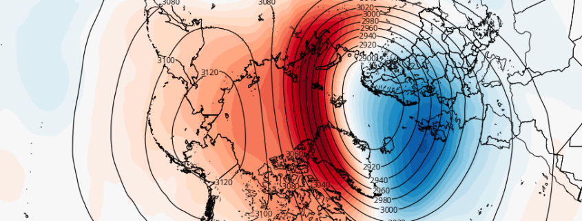
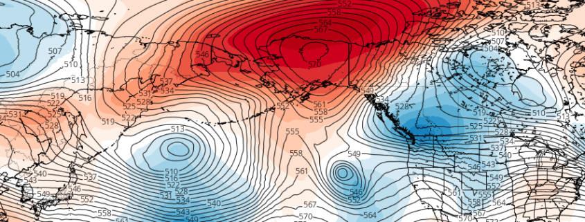
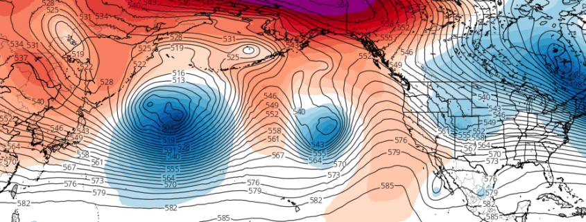
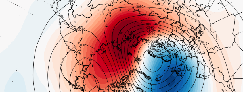
Yet, here we are, more than halfway through the winter, at what seems to be a breaking point of sorts. The atmosphere, from the troposphere to the stratosphere, is about to undergo some significant changes, most of which will have a large impact on the weather we experience here across the lower 48. Much of this begins in the Pacific Ocean (Again) where the pattern is going to change once again — and ends in the stratosphere, where the large polar vortex is going to be significantly disrupted.

The sensible weather results throughout the lower 48 currently remain uncertain. But there are some clues to be found in the medium and long range forecast models. There are also clues to be found away from model guidance — not everything comes directly from them, after all. We can look to past events as well as basic synoptic meteorology to begin to understand how the pattern will evolve through February and beyond.

We break down what’s going on in our latest video:

The role of the MJO and stratosphere in the long range pattern

The pattern is changing — again. We discussed in an article on Monday how the Pacific Ocean will play a large role in the long-range pattern going forward. Currently, a jet extension in the Pacific Ocean is facilitating a progressive, mild pattern across the United States with storms tracking over the Central part of the country towards the Great Lakes. But tropical forcing and an MJO pulse will cause a deepening trough over Eastern Asia, with a developing standing wave (ridge) over the Eastern Pacific Ocean.

A huge change from the current state of the pattern, these developing waves in the Pacific Ocean are being caused by the MJO and tropical forcing developments, with additional impacts from the stratosphere. Lets dive in to the details of what is really causing the changing pattern — and why it’s so important.

Read more