Long Range: Models hinting at “cutoff low” next week

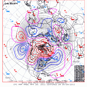
On the heels of a developing unsettled weather pattern for late this week, which we detailed in a post on Wednesday Night, forecast models are hinting that the medium and long range pattern could remain unsettled. The main feature in the medium and long range guidance now appears to be a large upper level “cutoff” low, which will cut off from the northern stream (northern jet stream) in Canada and drop into the Great Lakes and Northeast States next week. Such an occurrence isn’t exceptionally rare, especially in the Autumn and Spring. The resulting weather won’t be too extreme, either, but the cutoff lows usually provide a continuing chance of unsettled weather including showers during the day and cooler/cloudier weather in general. So, in essence, the development of the cutoff low as medium and long range guidance suggests would provide a continuing pattern of unsettled weather through early next week. Not all is lost under a cutoff low, however, as the weather can still be pleasant and sunny at times — but the threat for showers will always linger. The other wild card with cutoff lows is the duration of their stay — they can sometimes meander in the area for several days. Luckily, the current pattern isn’t overly slow, so the cutoff low should be pushed out eventually by another trough.

GFS Ensembles showing mid-atmospheric height anomalies. Note the cutoff low over the Great Lakes indicated by below normal anomalies.

Beyond the cutoff low, long range forecast models are indicative of a near-average pattern..but there are some hints of below normal anomalies in the mid-levels of the atmosphere working into the Central and Eastern United States by Day 10, with a large ridge on the West Coast of the United States. This is especially prevalent on the GFS Ensembles this morning. The Euro hints at a similar pattern — which adds some credibility to the potential for a developing below normal height pattern. Such a pattern would provide continued chances for precipitation and below normal temperatures as we head into the first few weeks of October. We’ll keep a close eye on it, especially now that we’re heading into October, where the pattern begins to take its first steps towards a hint at what to expect for winter. Yes,  the magic word. More updates in a few weeks (we love a good cliffhanger).

Stay tuned over the next several days for more updates on the potential cutoff upper level low and its impacts on the weather in the NYC Area next week. And, of course, keep a close eye on our Facebook and Twitter accounts for constant updates on the near and short term weather late this week and weekend.

Below normal temperatures could return

It’s been quite a run. A 12 to 13 month run, actually. Dating back to April 2011, above normal temperature anomalies have generally dominated the weather pattern in our area. That’s right, since

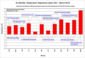
New Jersey 12 month temperature departure chart and highlights. Credit: Rutgers Climate Center

since April 2011, there has not been one month which featured below normal temperature anomalies. To clear up some confusion (we’ve read your emails and tweets), temperature anomalies being above or below normal doesn’t necessarily mean it’s scorching hot or freezing cold each day. The temperature anomalies, instead, signify the amount of degrees that the temperature differed from the long-term average for the month. So for instance, if the calculated average temperature for March in NYC was 60 degrees since 1900, and March 2012 averaged 62 degrees, our departure would be +2 degrees.

With that cleared up, we can get an idea of how much of a streak we really have been on. Sure, there have been periods of below normal temperatures. We’ve seen them for a few days behind cold fronts, on the north side of warm fronts, and behind major storm systems. But the above normal anomalies have, obviously, been longer lasting and more intense. The image to the right shows the 12 month highlights of these above normal temperature departures in New Jersey (don’t worry, they aren’t that much different in New York City itself). It’s pretty easy to see that not only was the warmth present, but it was setting records along the way as well. Several months in a row were placed among the top-ten warmest since records began being recorded in New Jersey. On a larger scale, all of the four seasons in the year were in the top 5 warmest ever, and the most recent month of March 2012 was the warmest March on record.

GFS Model (4/29/12) Forecast 500mb Height Anomaly average in the 8-14 day period

But now, it seems the pattern may want to change a bit. Forecast models are beginning to lock on to the potential for below-normal height anomalies in the 8-14 day range. This doesn’t guarantee below normal temperatures, but it does mean it will be somewhat difficult to maintain above normal temperatures, if a persistent trough is present (signified by the below normal heights). The GFS has been most aggressive with this feature, but more recently the ECMWF has jumped on board as well. Don’t fret, though, if you enjoy the warm weather. It also looks like a brief period of warm weather, with above normal temperatures, will preface this potential below-normal event, during the middle of the coming week.

It remains to be seen if the forecast models are on to something — or if the above normal temperatures will be able to persist, despite the potential for below normal anomalies in the mid levels of the atmosphere. That being said, this is certainly the first time we’ve seen the forecast models advertising the potential for this with some consistency. We’ll be watching it carefully, and we’ll see if the streak of above-normal anomalies will go down without a fight. Something tells us it won’t.