Blocking episode may create forecast headache

Blocking, both over Eastern Canada and in the high latitudes, more often than not means a forecast headache for our forecast area. We’ve seen it on many occasions with winter storms — as the strong blocking highs create anomalous weather patterns. We saw it with Hurricane Sandy, and the Nor’Easter that followed. And it seems that we may see it again, as we head towards the first week of May.

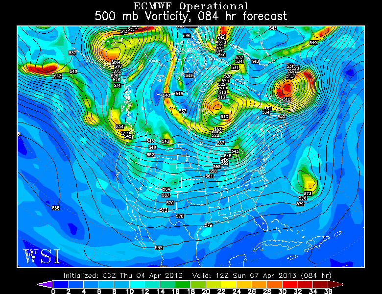
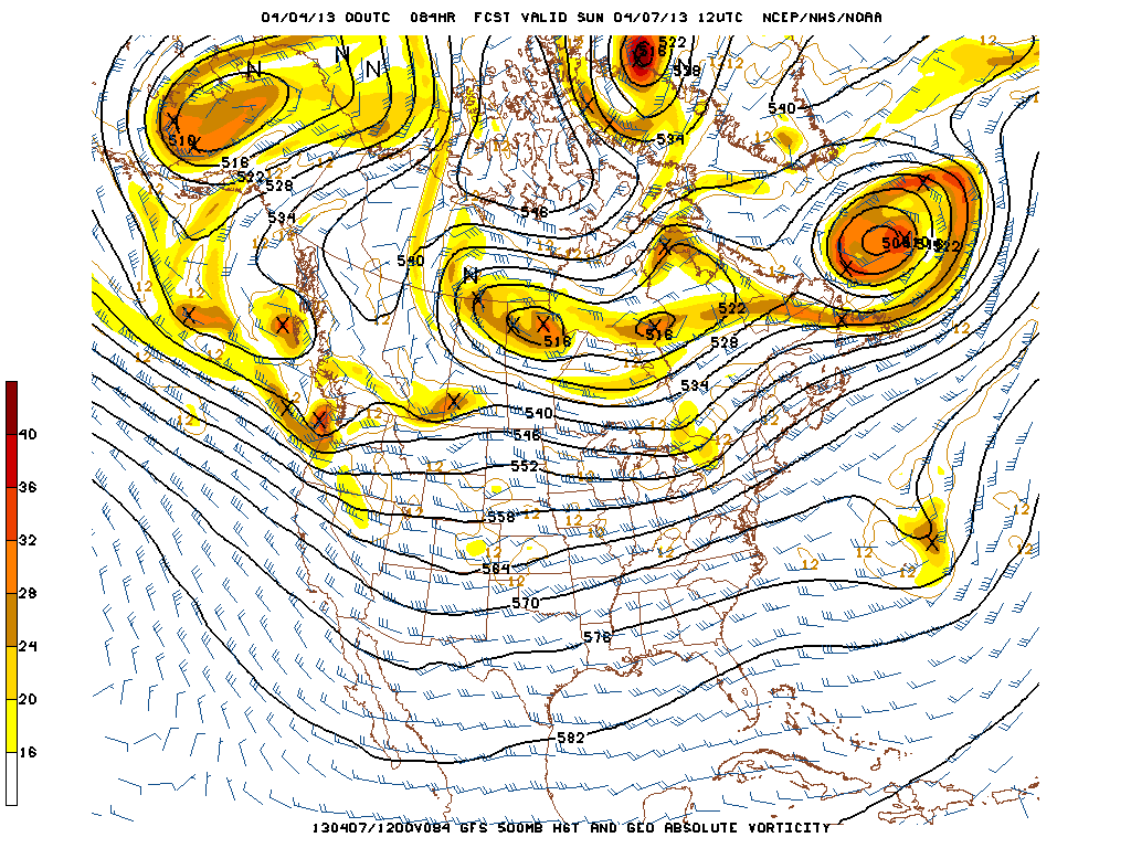
Forecast models are coming into agreement on the potential for an anomalous blocking pattern to develop over Eastern Canada and the Northwest Atlantic towards Newfoundland. With a shortwave trough predicted to be over Central Canada at that time, the trough may be forced underneath the block into the Ohio Valley and the Mid-Atlantic/East Coast. This would create the opportunity for a “cutoff low” and possibly even a coastal storm — with widespread below normal temperature anomalies wherever the cutoff low and upper level trough tracks.

At this range, the question becomes: How strong will the blocking be, and where will it develop? The positioning of the block, as well as its strength, will have a great deal of impact in determining where the cutoff low will eventually track. This will, in turn, have major impacts on the sensible weather forecast for our area. Needless to say, the potential is there for a prolonged period of showers and unsettled weather — as well as a coastal storm — if the cutoff tracks near our area. If it remains farther south, we may be spared the worst effects.

Forecast models are still struggling with the positioning of the block and positioning of the cutoff low. The Euro (or ECMWF), for example, has the cutoff low staying well to our south while the GFS and Canadian models bring it closer to our area with a prolonged period of rain in the Mid-Atlantic states.

In situations like this one, forecasters can utilize ensembles to see the variance amongst forecast models. In this case, we can check out the GFS Ensembles — which show the average height anomalies at 500mb (mid levels of the atmoshpere) on the left, and the “spaghetti” plot of each ensemble on the right. It is easy to see that most ensembles agree on the strong block developing over Newfoundland and Eastern Canada, but the exact positioning of the upper level trough over the Central US is less certain.

Forecasters will certainly be monitoring the models over the next several days, so be sure to stay tuned for updates on the potential unsettled pattern as we head towards next week. For now, enjoy the pleasant weather through the weekend!


To Spring or not to Spring? That is the Question.

Upon waking up to another chilly morning, most of us are probably wondering when Spring is coming. For those west of NYC, it probably arrives on Monday and Tuesday, but for those east of New York City, we might have to wait until April 15th or so. Forecast models are struggling immensely with the positioning of a warm front for next week, which throws lots of wrenches into the forecast.

A storm system will head up the coast on Friday and shoot into the Canadian Maritimes this weekend, and strengthen as it does so. That will help to keep things relatively chilly for the weekend, with the cooler northerly flow behind it. Once that storm system gets far enough to our north, heights will begin to rise, and this is when the potential warm-up begins. This is also when the European model and the GFS model really begin to diverge. The biggest difference is the way they handle a huge upper level low in Canada. The GFS splits the ULL into two and elongates it, while the Euro keeps it one large entity that dominates the pattern. The differences begin as soon as 84 hours (Sunday morning), as the GFS is already showing signs of splitting the feature and elongating it, while the Euro is much more powerful. Implications of this will be explained shortly.

The 00z Euro has the ULL as a much more powerful feature.

The 00z Euro at 84 hours has the ULL as a much more powerful feature.

The 00z GFS at 84 hours is splitting the ULL and elongating it.

The 00z GFS at 84 hours is splitting the ULL and elongating it.


One thing we do know is that it is clear that there are still remnants of the past blocking pattern in place. There are cutoff portions of very high heights in northern Canada; thus favoring closed off ULLs to form downstream. These patterns do not tend to run very warm, but the good news is that the core of the blocking for the most part is oriented a bit to the west of the NAO regions. Both models agree on a vigorous shortwave entering the Pacific NW, but it will not be allowed to race eastward, due to the ULL and the blocking. Thus, it is instead forced southward, underneath the block.
Read more

Sunday AM Update: Wintry pattern looms

The RGEM model shows moderate snow in the NYC area at 5 p.m. Monday

The RGEM model shows moderate snow in the NYC area at 5 p.m. Monday

The NAO blocking has arrived, and much of the area saw periods of snow during the day on Saturday, enough to remind us that winter is still holding its grip on us, despite the calendar turning towards Mid March. We are also following the potential for two storm systems; one for Monday evening through Tuesday morning, and another one as we approach the March 24 period. Monday evening through Tuesday morning looks more rainy and messy than snowy, though further northwest of the city might be able to hold onto enough cold for minor snowfall accumulations along with some ice. However, March 24 is a period that needs to be watched for more serious snowfall potential, albeit it is quite far away, so caution should still be urged.

A stronger storm system will be developing to our west, as energy enters the United States from the Pacific Ocean. Considering we have a decently cold airmass in place right now, the precipitation that moves into our area could start off as snow, as warm, moist air overruns the cold air in place. If enough solid precipitation can break out to the east of the storm system, then we might see precipitation before the warm air advection would settle in. The RGEM model illustrates this well, as it shows a several hour period of snow for the NYC area, and then turning over to sleet.

Read more

VIDEO: Eventual flip to wintry pattern seems likely

Our latest long term discussion is now available (As it will be every mid-week from now on) via a video discussion which is posted to our YouTube channel. This week, our main topic of discussion is the eventual pattern change to one which could favor colder temperatures and chances for snow — especially in January and February. Check out the video for details!