Colder, active pattern looks likely to open meteorological winter

Although many of us have already seen a significant snowfall on November 7th, we are getting closer to December — the start of meteorological winter — so many of you must be wondering when to expect more snow. I can’t tell you that specifically, but a detailed model analysis may point to a relatively favorable scenario for snow lovers come the first half of December.

Last November and December, there was no high latitude blocking or ridging, which bottled up all of the cold in Alaska and the Poles, and there was no cold air source in Central and Southern Canada. However, there are signs of a strong developing cold air source in Canada, which is one of many steps that need to be taken in order to generate a snowy pattern. How does this cold air source result and will there be any mechanisms to bring that cold air down to the eastern half of the United States?

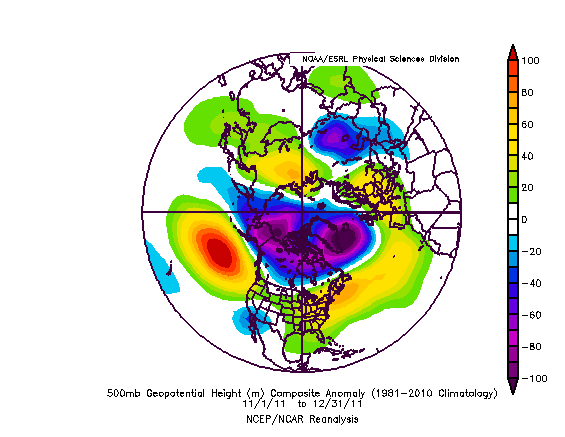
An anomaly composite from last November and December shows a lack of any high latitude blocking and ridging, which kept the cold air bottled up in the Arctic. This resulted in a very warm pattern for the Continental US.

A below normal temperature pattern has been settled into much of the Northeast United States since the start of November, but aside from the early-month Nor’easter things have remained relatively calm and dry. This time of year is always interesting, meteorologically, as the pattern undergoes tremendous changes as winter starts to take hold. Lower heights, stronger systems, and colder air start getting involved — and forecasters start looking ahead to the winter. Last year at this time, forecasters were staring at data which pointed at an unusually warm start to winter that would continue through at least New Years. Some of which included low snow and ice cover and a lack of any high latitude blocking. The composite image shown to the right illustrates this quite well; there was nothing favorable last year for cold and snow.

This year, we are seeing the emergence of the polar (no pun intended) opposite pattern. Forecast models and long range data are pointing to the development of several key features which will set off a sequence of events that, historically, lead to colder and more active patterns in our area. We’ll take a look at what the data is showing below:

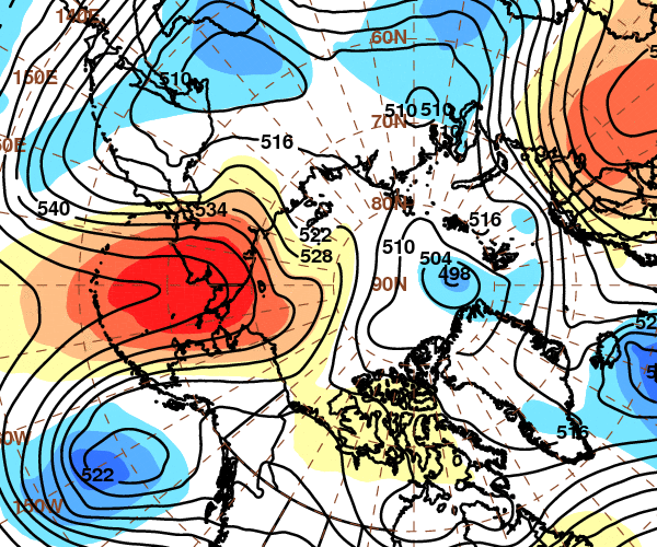
GFS height anomalies at 500mb (mid levels of the atmosphere) showing the anomalous ridge over the Aleutians and Northwest Alaska.

A Strong Aleutian Ridge: This feature may be the most underrated signal for pattern changes in the Northern 1/3 of the US. A strong ridge over the Aleutians and into Alaska can successfully dislodge cold air from Northern Canada and the poles into Central Canada and even the Northern 1/3 of the United States. With snow cover already above normal in that area this time of year, this development becomes very important. More cold air and below normal height anomalies for a few weeks over that area will set the stage for the presence of cold air to our north to start the meteorological winter. Additionally, forecast guidance has this feature developing into an anomaly — and a dominant one at that. +2.0 to +3.0 standard anomaly of heights throughout much of the Aleutians into Western Alaska is a common theme on mid range model guidance and ensembles. Even more interesting, down the road, is the potential impact this anomalous feature could have on the pattern. We don’t have to look far to find the last time one of these Aleutian Ridges popped up — and we can also find a familiar theme on the developments it sets off on the model guidance today.


Read more

Concern builds as Tropical Storm Sandy provides forecasting headache

European forecast model showing TS Sandy, phased with a trough over the Central US, as a very strong storm at 933mb just off the New Jersey coast. Such a strong storm is almost unprecedented for our area.

Forecast models continue to waiver with track, intensity, and impacts on a potential major storm system developing off the East Coast at the end of this coming weekend and continuing into early next week. Earlier this week we outlined the potential in the long range for a system, but dismissed the hype which was already growing, with some outlets already talking about wind numbers and rain potential. Now that we are a few days closer to the event, and around 5 days away from potential impacts, we have some slightly increased confidence that the storm will at least have a chance of bringing impacts to our area. In essence, the storm isn’t just a “fantasy land” storm on forecast models anymore — it seems to be a legitimate possibility (not a certainty). So, we’ll lay out all details below with a full explanation of the event in which we try to answer any questions you may have in regards to the storm and it’s impact on the weather in the NYC area.

What’s the deal with this threat, why is it developing in the first place? Tropical Storm Sandy formed a few days ago in the Caribbean. The storm is strengthening a bit and is expected to drift northward over the next day or two, into the Northern Carribean and southwest Atlantic. The pattern over the United States and Northern Atlantic ocean is completely blocked up (i.e, the pattern is very amplified, with unusually deep troughs and ridges thanks to a very low NAO and AO index). This means the steering flow (what guides the tropical storm) will bring it out of the Caribbean and then on a north, possibly northeast heading for a while. More often than not, storms in this position head out to sea. But as you can see in this diagram, there is not much room for Sandy to do that. The ridge axis building over the top of her and to her east over the Atlantic remains strong. And to the west of her, over the Central US, you can see a trough beginning to dive south and east.

Keep reading for details, diagrams, and thoughts on the potential threat…

Read more

Hype meter rising on potential weekend storm: What’s the deal?

ECMWF Forecast Model showing a very strong storm system off the East Coast early next week. It is one of a few models showing the potential system in the long range (beyond 6 days).

The meteorological community is buzzing in regards to the potential for a major storm system this weekend, which could affect much of the Eastern United States. Local media has caught on to the potential and is beginning to hype up the potential storm system — as are several weather forecast outlets in the area. However, it is important to remember that the system is still floating around in what meteorologists like to call “Fantasy land” on forecast models. The range where, especially in a high amplitude pattern, models are prone to wild and wacky solutions. In this case, we’re seeing some of the wildest solutions in recent memory — and it’s causing the meteorological community to hype up the potential for a major storm. That being said, taking a look at some of the pieces of the pattern can offer us clues as to where the potential actually lies — aside from the wild model guidance images floating around the internet. We’ll try to answer some of the questions we’ve had emailed/tweeted/facebooked at us throughout the day today.

Why is there a storm threat, where is it developing? One of the major causes behind the threat for a significant storm is the development of a tropical system (Tropical Depression 18) and a large trough over the Central United States, which is then forecast to surge south and east and phase with the tropical system. A phase occurs when two or more pieces of the jet stream interact with one another. In this case, the Central US (northern stream) trough could surge south and east to phase with the tropical entity by next weekend.

Keep reading for a full discussion on the potential and hype…

Read more

Long Range: High latitude blocking could set off major changes

GFS Model Ensembles 500mb Standard Height Anomalies, showing high latitude blocking from the North Atlantic, through the Davis Straight, and north of the Aleutians.

It has been a while since the meteorological community has been given the chance to analyze some high latitude blocking, at least blocking that looks to have a fighting chance at actually coming to fruition. The last major high latitude blocking event in the fall or winter season came in January-February 2011, and was one of the major causes of an unusually cold and snowy winter in the Eastern US. Since then, many blocking episodes have been modeled too strongly in the medium range, only to appear weak and meager in reality. This time, however, teleconnections support the development of strong blocking not just in the Atlantic, but from north of the Aleutians as well. Medium range ensemble guidance supports positive height anomalies (+3 to +4 Std. Anomaly of height at 500mb) by 72 hours, or the middle of this upcoming week as you can see in our lead image right above this text.

The three major areas of positive height anomalies at 500mb are fairly classic — one from the North Atlantic (which will eventually surge westward towards Greenland), one over Central Canada west of the Davis Straight, and the aforementioned major block with very impressive positive anomalies north of the Aleutians. The three would effectively keep the high latitude well “blocked” through the medium range — something we have only seen in spurts during the past several months.

GFS Ensemble Mean temperature departures on Day 6 (Saturday 10/27/12) showing an outbreak of cold air over the Central US heading east.

With the high latitude blocking development, most if not all of medium range model guidance has -NAO values through the long term with no major rise in the near future. The GEFS mean NAO forecast plume shows values of near -2.0 through the end of the period. You may be asking yourself, after a broad brush of the pattern — despite this, most of the forecast models are showing a ridge in the east and above normal temperatures. So what gives? The answer is a strongly -PNA with the Aleutian/Alaskan ridge correlating well with a big trough over the West Coast by Day 5. The southeast ridge flexes its muscles in the east allowing for positive temperature anomalies to develop. However, in such a pattern…it is only a matter of time before a major shot of cold air is forced southward underneath the blocking into Central Canada and eventually the Central/Eastern US. This will likely come in the form of a large upper air trough by Day 7, easily visible on the GFS temperature departure means to the left.

Keep Reading for a full discussion on the long range, including a cold air surge and potential tropical systems…

Read more