The stratosphere, blocking, and a hemispheric pattern change

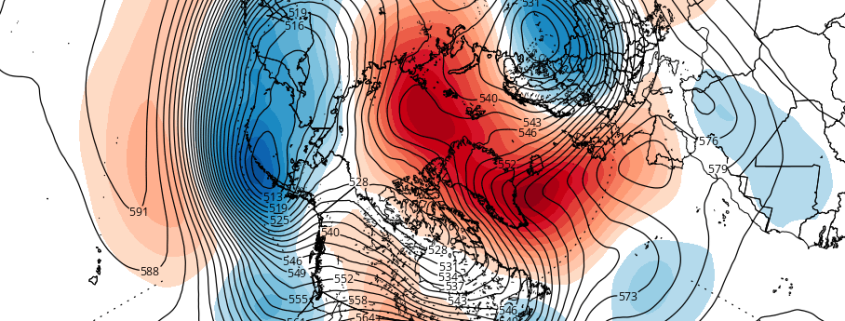
What exactly could a ridge in the Kara Sea, the remnants of Hurricane Nicole, and a circulation in the stratosphere all have in common? They’ll all have significant impacts on a changing weather pattern in the Northern Hemisphere over the next two weeks. Meteorology is a fickle, uncertain, and highly detailed process in almost every regard. But every once and a while, the fluid process that runs through our planets entire atmosphere can give us a show — where multiple processes come together, and they can be easily visualized and understood.

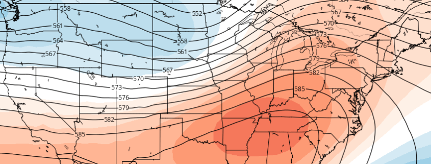
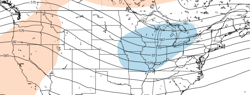
What’s occurring over the next 7 days is, by and large, a hemispheric pattern change. The progressive pattern across the United States, which has been dominated by a Pacific Jet and relatively uneventful disturbances, will undoubtedly shift. Changing wavelengths are likely to make the pattern changes effects even more dramatic. But the most interesting aspect is where, when and why these changes are occurring.

Read more

Significant warmth across the US next week, but will it last?

The hemispheric pattern evolution over the next 7-10 days will be quite intricate, to say the least, and could potentially include both a significant — possibly record breaking — warmup, and a large scale cooldown directly behind it. The pattern changes and evolution are being largely driven by changes that are ongoing in the Pacific Ocean, as a large low pressure system and mid level trough form in the Gulf of Alaska. This forces dramatic changes to the pattern across the Continental United States.

Late this week, a large trough centered near the Aleutian Islands of Alaska will begin a dramatic shift. This trough — overall — has been centered near the Aleutians for quite some time now. But a changing pattern, wavelengths, and an extra boost from a recurving typhoon will help to bring forth the change. The Aleutians trough shifts southeast by hundreds of miles this weekend, resulting in a significant storm system pushing into the Pacific Northwest.

Read more

Long Range: Cooler, active pattern ahead for Central US

Far away from the United States, in the equatorial Pacific, a propagating MJO has some ideas as to how the weather pattern will evolve through early October. Okay, maybe that’s not exactly how it works. But the development of an MJO wave will, in fact, aid in the patterns progression over the United States through the end of September. The instra-seasonal traveling pattern of convection more affectionately known as the MJO (Madden Julian Oscillation) has significant impacts on our weather, and this occurrence will be no different. You can read more about the MJO right here.

While the MJO has been stuck in a period of inactivity over the past several weeks, the overall hemispheric pattern has fallen into a bit of a lull. Wash, rinse, repeat has been the overall terminology used. Occasional cold fronts and troughs have brought periods of below normal air to the Central United States while, by and large, the East Coast has remained at the mercy of a large Southeast US and Western Atlantic ridge.

Read more

ENSO state in limbo as La Nina struggles

Much fuss has been made over the past several months in regards to the development of La Nina this year, coming on the heels of one of the strongest El Nino’s on record. There is a propensity for these things to occur, after all, and a significant cooling of Nino-region pacific temperatures led many to believe that a La Nina was not only on its way — but could be moderate or strong by the time cold season arrived in the Northern Hemisphere. Those ideas will not come to fruition.

The lack of La Nina development has, instead, been notable — with a significant lack of depth to any cooler sea surface temperature anomalies. Trade winds aren’t cooperating (we’ll get into that more later) and tropical forcing seems to favor this pattern continuing through the next few months. It appears likely, now, that La Nina will never truly get off the ground. Forecast models have responded, with monthly and seasonal data now pointing to a Neutral (La Nada) pattern through at least the first half of North America’s calendar Winter.

Read more