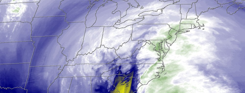
Was the NAM’s blizzard forecast really that good?

Oh, the NAM. The source of so many colorful snowfall projections that spread like wildfire across social media. The weather model that gives meteorologists fits multiple times per season. The weather model that can pick out thunderstorms two days in advance, and completely mishandle a snowstorm at a 24 hour lead time. And now, the weather model that absolutely nailed the forecast for the Blizzard of 2016 in New York City.

The Blizzard of 2016 will likely go down as one of the most effectively modeled snowstorms in meteorological history. The signal for the storm system was evident as far as 8 days in advance (arguably longer via long range pattern recognition). Long range ensemble guidance and even individual operational model runs showed the storm systems evolution consistently 6 to 8 days in advance, with increasing agreement on a major low pressure system off the East Coast. And, up until Day 5 or so, the agreement was relatively unanimous among major global models such as the GFS, Euro and Canadian.

Read more

Buried: Blizzard of 2016 becomes one of the greats

Let’s get this out of the way: On Wednesday evening, we made a post explaining why we were confident New York City would avoid blockbuster snowfall totals from this weekends storm.

We were wrong.

A last minute, buzzer-beater type north trend resulted in tremendous heavy snow bands moving over New York City on Saturday. All-time snowfall records were broken at Kennedy Airport (30.5″), LaGuardia Airport (27.9″). Central Park reported its second largest snowfall of all time at 26.8″, just .1″ shy of the record set back in February 2006. The impacts on the area were immense – with New York City shut down to all travel from 2:30pm Saturday until 7:00am Sunday.

The atmospheric dynamics at play during the storm system were even more incredible than the snow that fell. Tremendous lift, energy, and moisture surged northward on Saturday as a low pressure system tucked in near the Mid-Atlantic Coast. Bands of heavy snow surged north through New Jersey, with whiteout conditions and snowfall rates of 2″ per hour. These bands of snow quickly made their way toward New York City and Northeast New Jersey on Saturday morning — setting up from southwest to northeast through NJ, NYC, Long Island, and SW CT.

Read more

The meteorology, and stats, behind the 2015 Hurricane Season

Meteorological Winter began today, and the 2015 Hurricane Season officially ended yesterday, marking a transition in seasons — and the attention of meteorologists worldwide. While the season will be remembered for a few more significant storms, the overall season in the Atlantic was quiet. There were 11 named storms and one more tropical depression. Four of those named storms became hurricanes and two of those became major hurricanes (Category 3 or higher). The number of named  storms is actually about average for Atlantic hurricane seasons between 1966-2009. But the number of hurricanes is below the average of 6 for the season. Only two storms made landfall in the in the United States: An early season tropical storm named Ana over North Carolina in May, and then Tropical Storm Bill over Texas in June. There hasn’t been a major hurricane landfall in the United States since Hurricane Wilma in 2005 — which is now 10 years ago.

Read more

On this winter, records, and cold

I enjoy data. New York City’s weather station has been keeping data records for 152 years. Yes, that’s right, observers have been collecting weather data in New York City since 1863. That, my friends, is a long time ago. Since then, there have been an innumerable amount of impressive weather events. Hurricanes, winter storms, severe weather, flooding, heat, cold. New York City’s geographic location features an incredible amount of variability and extreme differences based on location. These simple facts, as straightforward as they are, make this winter — especially from February through early March — all the more impressive.

When looking at this winter as a retrospective, although it isn’t yet over, one can easily become caught up in statistics and information. This February through March in New York City will go down in the record books as one of the more impressive and extreme winter weather periods. For both cold and snow, the past 60 days have been historic.

Read more