Period of heavy rain likely tonight into Saturday AM
A dynamic storm system moving through the Northeast US will bring a slew of significant weather effects to the Mid-Atlantic states today. In fact, the

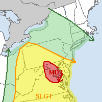
Day 1 Severe Weather Outlook showing a rare moderate risk over the DC Region, and less risk in our area. (Storm Prediction Center)
Storm Prediction Center has issued a rare Moderate Risk (the second in just one week on the East Coast), this time farther to our south over the Mid-Atlantic including the Capital region as well as parts of Maryland and Virginia. Strong to severe thunderstorms are expected there, with a heightened potential for tornadoes, some potentially strong. For more information on the severe weather threat there, visit our friends at Capital Weather, the Storm Prediction Center, or the Washington D.C National Weather Service. In our area, the severe weather threat will much less (in fact, it will be quite low).
The culprit in the difference in weather? A warm front, which lies between the Mid-Atlantic and our area. This warm front is allowing for warm and unstable air to surge into the Mid-Atlantic, while keeping our area cooler and more stable. Overnight tonight, this front will move north and a cold front will sweep through, bringing a period of rain (possibly heavy at times) through the area. A rumble of thunder or a gust of strong wind isn’t out of the question, but the severe weather threat is overall expected to be very low.
The good news is that clearing is expected by late-morning on Saturday, giving way to fair weather and temperatures in the 70’s by Saturday afternoon and evening. Some showers and storms could be scattered around on Sunday afternoon, but the weekend certainly doesn’t look like a washout.

